Humminbird Helix Marking and Navigating to a Waypoint

Вставка
- Опубліковано 22 лис 2021
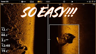
- Here’s how I mark waypoints on my Humminbird Helix including how I use the select icon feature opposed to using the default icon. This video was requested from a couple who watched one of my earlier UA-cam videos. They wanted to know how to mark a waypoint and navigate to a waypoint. I created this video to help answer their questions. In this video, I mark a waypoint, select an icon, and navigate to an existing waypoint. Prior to making this video, I referred Vicki and Marv to an earlier video, Humminbird Helix Zoom In & Zoom Out Keys, on my UA-cam channel, Steve Chiasson Fishing. They found this video quite helpful. The section on navigating to a waypoint takes place from the time frame 8:45-12:40. This example shows an enlarged version of the go to navigation grid because it’s a shorter distance plus a more complete navigation to the waypoint. By watching this video and the Zoom Keys video, you will be able to mark a waypoint, select your desired icon, and navigate to a waypoint.


Excellent video. Thank you!!
Thanks for taking the time to share your kind words.
Hey Steve,
Can’t thank You enough for posting this video, we appreciate you taking the time to show us this information. I knew how to mark a waypoint, but didn’t know how to highlight it and return to it. You explained it simply, great job, as always really enjoy your video’s.
Vicki and Marv
Thank you for your questions and kind comments. I am glad that the videos have helped you with your Humminbird Helix.
M😊😊
great job you make it easy to understand thanks a lot
Thanks for the kind words Julie. It always makes my day when someone finds my videos helpful!
I like Your Videos they help us newbies understand a little more clearly. I would like to see more on the One Boat Network on how you command the trolling motor to navigate to your waypoints and setting the jog feature. I would like to understand the follow the contoure as well. Just some Ideas for you on some future vids. thanksmfor your content.
Thank you for the suggestions, I was thinking about doing a follow the contour video. Waiting for ice out on a lot of our lakes around here.
Good info! Have a Helix 10 SI G2 and watching your Helix 12 SI. Wanting to benefit from G4 or newest Humminbird this Winter or next Spring. Should I buy the Helix 12 for better resolution locating fish? I will also buy a Mega 360 with side mount as my Minnkota Terrova is 12 years old. Question: can I get by with a Down Image model if the Mega 360 offers side image also?
Helix 12 has better resolution than the 10. You won’t regret the bigger unit. Both my units on the bow are Helix 12 G3N MDI+.
Hi Steve, thanks for the instructive video.
You kind of addressed this, but if i am navigating through a maze of islands, will it chart a water course arounf the islands for me, or just chart a straight line "through" islands, reefs, and rockpiles. In otherwords, does it take into acvount the Lakemaster overlay?
Thank you.
You’re quite welcome Jon. You need to plan a route to avoid obstacles such as islands.
@@stevechiassonfishing5876 Thanks, Steve. That seems like it wouldn't be tough coding to improve that. I would think Humminbird is working that. I can't be the only one!
Possibly but it’s not that hard to set up a custom route that would be the individual’s preferred choice.
Thanks again!
Thanks for tips! Separate question. I see your map contour lines when you zoomed in had the depth numbers on each contour line. Mine does not. I have to manually count them. Is there a setting?
Hi Alan, I am not currently sitting at my unit. Yes there is a setting to make your contour lines visible. Under the toolbar (menu, menu), go to chart, then scroll down to spot soundings and make sure it’s on the visible setting, not hidden. On older units, it might be something different but similar. Try spot sounding first. If that, does not work, go to the tabs at the top of the tool bar and scroll through options till you find something that sounds close then change it from hidden to visible. Let me know how you make out.
@@stevechiassonfishing5876 idont have a problem with showing the contour Ines. I have that checked and they appear. It's the visible numbers that indicate the depth. They seem to appear every 5 contour lines. When I fet a chance I will take a picture of mine and of what I see on yours and post if I can. Thanks for the reply. -- I guess I cannot attach photos. 😞
Sorry for the misunderstanding, using the + key to zoom in could be another thing to try. Map source is another possibility, make sure it recognizes the chip you are using, whether it be Navionics or Lakemaster.
@@stevechiassonfishing5876I have the Lakemaster chip, and it is recognized. So on taking a picture I selected a nearby map/lake. I use the cursor to scroll to a spot as I zoom into to lake. I noticed in one section the numbers are few, however another section they appear on every line. Hmmmm. Let me ask another question since I will have to to check it out on the water without the cursor showing. At the most zoomed why are the lines and few numbers all zagged?
When things are over zoomed, they can look different.
I woiuld have been interested in seeing what happens to those lines when a boat goes off course. Do they swing over with the boat? Or what?
The boat icon veers outside of the lines alerting you to steer the boat back the lines to help you navigate.
Steve I want to use my Humminbird Helix linked to my Minnkotta to steer my Lund while powering the boat with my 15H trolling engine. How do I set multiple way points to follow? Have you already done a video on this?
You want to create a route. Use the cursor control key to select a waypoint you want then hit GO TO key twice then repeat steps 1 and 2 to add waypoints. To save the current route, be in chart view, press the menu key once, then save the current route.
I have a helix 9 msi g4n. How do I get that "I believe it's called RTS screen to come up"? It's the left side screen on the split screen in your video. I can't seem to find it.
Hit menu, menu, find the “Setup” tab at the top, scroll to “User Mode” and make sure you are in Custom mode as it gives you more options. Then go back to the top and go from “Setup” to “Sonar” tab, scroll down to “RTS” window and select your preference.
When you see structure on your down imaging, is it right under the boat or 30 ft on either side?
Hi Bud, when I am using mega down imaging in shallower water the image is basically right under the boat. If you are using 800 kHz, you will get a wider image like a 45 degree angle. Think of it more as a triangular, narrow beam as opposed to a cone angle. If you go down to 455 kHz frequency, the image would be wider (75 degrees) so you would have more coverage to the sides of your boat. The deeper you are fishing the triangular beam will cover more images to the sides of your boat.
@@stevechiassonfishing5876 thank you
My helix 5 looses all my waypoints when I turn it off.the numbers remain but the points are gone. What setting controls the point memory?
Hi Don, assuming you have saved the waypoints correctly where you have the notification that waypoint saved as… then your waypoints should be stored in the unit. The waypoints are only saved on the unit you save them on. If you have multiple units, this could be an issue. If you only have the Helix 5, it’s possible the “motherboard” of the unit is done. I had an old 597 that I could no longer store waypoints on anymore. It was explained to me that the motherboard was done and needed to be replaced. I opted to replace it with a Helix 5 to go with newer technology.
Can you mark spots without having a lake pulled up? Our lake is too small and not listed on the lakemaster card.
Your best bet is to use Autochart Live to make a map of your lake. Start on your favourite fishing areas and just leave it on while you fish therefore it continues to make a map. A Zerolines card will be needed if you’re going to do more than 8 hours of mapping. If the lake you’re on shows up on your Humminbird Basemap you will be able to move your cursor and mark waypoints on your lake. If there’s no contours, it would be hard to mark spots.
Do you use/keep tracks on or just use a go to way points
I just use my waypoints, I haven’t bothered with tracks other than my current track which I use a reference all the time.
@@stevechiassonfishing5876 that’s what I just realized, keeps the screen clean. I have been keeping it turned on. Thanks
You’re quite welcome thanks for watching and commenting, much appreciated. 😊
can I rename a way point i.e. P for point? Art for artificial structure? and etc. Can I use the same name for multiple places (way points labeled P or Art). Very good videos, I now know know so much about my unit
Thanks Anthony and yes you definitely can rename, change icon, etc, watch video below
ua-cam.com/video/r8eYzPuBhcY/v-deo.html
@@stevechiassonfishing5876 just looking at now, You used the word hump, can I that name be used for other locations or only used once?
This is great, can’t thank you enough
No problem, yes you can use it again, if it’s a special hump you may want to designate it differently.
@@stevechiassonfishing5876 hummingbird should pay you or put you on there payroll
Kinda behind the time…..can the navigation be used if at the front with a trolling motor?
Thanks
With an IPilot Link, the trolling motor can do things like follow the contour.
Is the nav really linked to your big motor??
The nav is not linked to my big motor.
I just used the big motor to get me to the waypoint.
Good info, to bad you can't name the waypoint.
I have a video on my UA-cam channel, Steve Chiasson Fishing, look for the thumbnail picture, “Waypoints, Find, Edit, Name”.
Can you show how manually to install waypoints when not on the water
Will do when I get back from my trip.
Hi Steve, I filmed it tonight and will release it later tomorrow afternoon.
Okay thanks
Video is up on my UA-cam channel, Steve Chiasson Fishing. Hope you enjoy the video!
Why does every hummingbird fish finder video have hummingbird hats sweaters or both?
Many anglers are proud to be associated with the product that we use and believe in. Many golfers wear Titleist hats because of that’s what they use and have confidence in. Some anglers are on pro staff programs and are helping promote product.
By the time you changed your icon……………. You are on the other side of the lake……..this is a issue humminbird 😢
The Solix and Apex touch screens are much quicker than the Helix. There are pros and cons in electronics, personally I can live with it considering all the advantages of the Helix.
Please remember the direct route is not the best way. This could make it a horrible trip.
In that particular case it was a pretty direct route.
Sure wish you could delete the icon choices. I mean one icon is a rooster! A ROOSTER! Who makes this crap?!
Yes it can be frustrating to scroll down though the icon choices. Changing the default icon to what you are looking for that day is a time saver. If I am looking for rockpiles, I set the icon to rocks and it saves it automatically when I mark a waypoint.