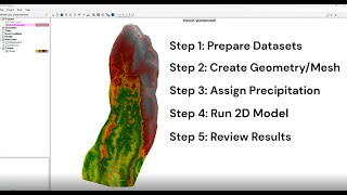
Thank you very much doctor. It would be very interesting to carry out an analysis for bridges with SA/2D connection with a flow that passes under the bridge deck, many times it generates a very large backwater upstream of the bridge, forcing me to enter the pillars and abutments of the bridge as modifications. of terrain in RasMapper. I'm sure I'm making a mistake in entering the data, it would be interesting to see it from your perspective. Thank you very much for your attention doctor.
That really has little to do with the bridge/SA connection. You need to investigate your computational time step, surrounding cell sizes, boundary condition data and bridge modeling approach for low and high flow
Garbage in garbage out will always hold true in numerical modeling. You have to know what you are really doing with tons of tests and studying documentation and builds by others.@@patrickbrandonportellalivi4196
@Stanford Gibson, Hello! Great content as always. Dear Gibson, where I can report a minor error I have been getting on the new version of the Hec-ras. The new 6.4.1 version is giving an error when starting the water quality simulation, saying that the preprocessed geometry could not be found, it only happens on the non-permanent flux. Best regards and keep up the top tier work.
I love the ability to add culvert barrel GIS data to connect cells away from the structure centerline. It would be great if structure breaches had this same ability. Large dam embankments and smallish cell sizes don't play nice
Good question. No...it did not. This is an important point. The culvert length stays the same that you specified...the coordinates just determine the headwater and tailwater elevations/cells.


Thank you for your comprehensive explanation.
Thank you for this. That last bit about the checking the cell elevation that the structure is connected to helped me solve the error on my model.
Great. Yeah, that is a common issue.
Thank you very much doctor. It would be very interesting to carry out an analysis for bridges with SA/2D connection with a flow that passes under the bridge deck, many times it generates a very large backwater upstream of the bridge, forcing me to enter the pillars and abutments of the bridge as modifications. of terrain in RasMapper. I'm sure I'm making a mistake in entering the data, it would be interesting to see it from your perspective. Thank you very much for your attention doctor.
That really has little to do with the bridge/SA connection. You need to investigate your computational time step, surrounding cell sizes, boundary condition data and bridge modeling approach for low and high flow
@@civilengggggok but i doubt it
Garbage in garbage out will always hold true in numerical modeling. You have to know what you are really doing with tons of tests and studying documentation and builds by others.@@patrickbrandonportellalivi4196
@Stanford Gibson, Hello! Great content as always. Dear Gibson, where I can report a minor error I have been getting on the new version of the Hec-ras. The new 6.4.1 version is giving an error when starting the water quality simulation, saying that the preprocessed geometry could not be found, it only happens on the non-permanent flux. Best regards and keep up the top tier work.
I love the ability to add culvert barrel GIS data to connect cells away from the structure centerline. It would be great if structure breaches had this same ability. Large dam embankments and smallish cell sizes don't play nice
Thanks for looking for more such videos
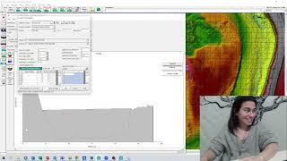
Thank you for the video. When you copied the coordinates into the barrel GIS data, did that change the length of the culvert?
Good question. No...it did not. This is an important point. The culvert length stays the same that you specified...the coordinates just determine the headwater and tailwater elevations/cells.
Thank you so much