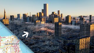
How to Create 3D Terrain with Google Maps and Blender!

Вставка
- Опубліковано 13 тра 2024
- Learn How to Create 3D Terrain Maps Free using Google Maps in this Blender Tutorial!
The first 500 people who click the link in the description will get 2 free months of Skillshare Premium: skl.sh/cggeek15
BlenderGIS: github.com/domlysz/BlenderGIS
HDRI: hdrihaven.com/
Dirt Texture: www.textures.com/download/3ds...
This video was sponsored by Skillshare
Music: chernebeats.com/
Subscribe: ua-cam.com/users/subscription_...
Instagram: / cg_geeks
Twitter: / cggeeks
Facebook: / cggeeks
ArtStation: www.artstation.com/artist/cg_...


Whoa! Didn't realize there was a free addon that did this. Awesome tutorial!
can u plz help me it didnt work
You are not the blender Guru, you are just a simulation of the real Guru
The Chosen one has blessed us with his presence 0.0
All hail the master
I am your fan blender guru..........
Pls help me,,,,,"Get STRM" is not working here
For those interested, SRTM stands for Shuttle Radar Topography Mission. This was done 20 years ago. It's basically binocular radar. One transmitter in the cargo bay, 1 receiver in the cargo bay. Then a boom extended 200 ft off the side of the shuttle with another receiver. Then they just turned it on and radar mapped the Earth as they flew over and got two signals from slightly different points of view (just like your eyes) and used that to computer really accurate terrain maps. It's a pretty cool mission.
Its good if you live and/or require to work on data that between 60'N and 60'S, as I live at 66'N you cannot use SRTM.
@@olavsantiago Not sure if it is any helpfull, but I was looking for a place far north of the 60`N and using the option: "Marine-geo.org GMRT" and it worked. I havent tried for any other places or checked what this Marine-geo is, but it worked for me
@@haraldmartinoff5587 will trying it later, as I want to be able to construct a 3D graphic at 66'N
@@olavsantiago I made from 63N and it went good
It's rather inaccurate in Sydney which is unfortunate
Dude, I wish one day I also can steer my mouse by telepathy
elon got u bro
@@jp-is1is he doesn't even have his car
I wish i don’t even need telepathy for it,
Hey FL tips, I've watched your videos for years. Thanks for the help.
Great tutorial. To the point. Not too slow. No uneeded stuff. Nice work.
1:08
CG Geek: "so while that's downloading then"
408 KB zip: "am I a joke to you?"
Maybe you're running dial-up? lol
got to get that ad plug in there some how.. lol
I have satillite internet.... that can take a minute atleast sometimes.... lol
@@kroutonjr How are you downloading games??? Haha
What?! Pheasants aren't allowed to have high speed internet, they must use DSL! XD
Wow, I wasted my entire weekend looking for a simple tutorial for this purpose. When I gave up on research, I found this one by chance. It's amazing.
OMG, this is the best way to do this. There are a bunch of tutorials on youtube on various ways to get the 3d data out of google maps / earth. This is the best one and simplest. I'm going to be making 3d prints of some locations for some last minute xmas gifts. Thanks!
This is amazing, going to have to watch the video at least 20 times until I take it all in! Brilliant, thanks.
I have been using GIS data for Architectural visualizations for 15 years now, and you just knocked HOURS of my work time, especially in areas where I needed the surrounding buildings!
I am impressed how you were able to explain the steps so clearly. Thank you for sharing your skills with us!
I'm a noob with blender and thought this was going to be a step by step. Whoa the way you blow through the program is amazing! Hoping to learn to interact with it as fluidly as you do! You should make tutorials for total noobs too 😁😁 Like this tutorial but super watered down.
dude goes way too fast and just fucks off on ya
You just blew my mind. This is INCREDIBLE!
That is a really cool add-on!! thanks for the breakdown! your videos have been a huge help for me while i learn this program!
This is great! GIS is so cool.
daniel???why is this not blowin up after 3 years????????
Great ! Really time saving if you need a background for your render
Wow, so well done! Thanks for posting, man! Very helpful.
"Open Street Map Data from Google" do you know how many people you just made scream?
He doesn't understand what OpenStreetMap means, does he?
Haha yup that was a slip up - Map Satellite Data from Google, not the Open Street Map Data.
Geeked out, but the point was made, everyone is gaga over this. The coder for the BlenderGIS is now a god among men, lol.
Im one of them hahaha
@@iamkrazashell3679 That plugin is so old though. Used it to make that pic in my avatar like 3 years ago and it wasn't even new back then. It's Mars btw, you can make the whole planet using GIS data, just don't use the highest resolution data or there will be way too many vertices and it'll crash, I used the second highest level and it was still around 25 million vertices if I remember correctly.
Dont forget you can press L (then scroll with middle mouse wheel) before you press E and increase the texture resolution by getting it to download the textures from a higher detail level but at the size yourve selected before you press E. (Hope I made sense :D )
Well that download took forever :P
@@TheUselessgeneration can get some super high res textures doing it this way though, best ive managed on my 16gb system was 3 ( I think) additional levels in which created 5700 tiles to stitch and resulted in a texture 35k x 17k. I tried to go higher but it didnt do the mosiac stage properly, maybe if i had 32gb+ of ram it would have worked :)
For those of us that are laughably unfamiliar (but not stupid), *when*/*where* are you talking about doing this?
@@tchmilfan After you have zoomed into the area you want to export you normally press E to export the base map texture. IF you press L before E you'll see the zoom level at the top will say (locked) you can now zoom into a higher detail level texture with a higher resolution by scrolling the mouse wheel. When its finished downloading you then press E to export and it will have the higher level detail texture. Does that explain things?
@@zandorius Got it. :-) Thanks
TNice tutorials is literally the best tutorial on UA-cam. It's right to the point, and very informative at the sa ti. Thank you so much
Hi, thank you this is terrific. I have started this tutorial with some students with good results and they are very enthusiastic!
I would love to see a detailed city render video! This video was very helpful.
Jesse Fanta yeah, and I'm really interested in how elevation geodata consider more usual triangular roof shapes (instead of flat ones). In my experience it flattens them out, but I hope I'm wrong.
@@peaolo The elevation geodata does not automap buildings. The elevation data is gathered trough infrared scans of the surface and it's not higres enough to get individual buildings, so the building data is added in manually. It's actually sort of a pain to work with because in cities where the buildings "trick" the scans into thinking the ground is higher than it actually is sort of messes up the terrain inside cities. In most cases unusual roofs or other building features are not in included in the data and you'll have to go around and make all the buildings yourself using the data as a guide. And even if it was included the program that converts that data into models likely aren't going to account for it. The program I've found works best for generating cities is osm2world because it uses a lot of the data, including buildings, roads, bridges, tunnels, parks, water, pavement, railroads, benches, bus stops, and so on, and it has some rudimentary models for things like bridges, trees and benches or whatever, not that they're all that usable but at least you get to see where things go. It also assigned different textures that will help you know what things are, and it names everything according to addresses so you can look up what things actually looks like on a picture or something. But on the downside it imports this on a flat plane so good luck making every single building match up with ground elevation data, not to mention the roads, especially for a city center where the elevation data is messed up. And it also sometimes fails to account for levels, which means a triple stepped tower can end up as 3 boxes that are each aligned to the ground level when they should be stacked on top of each other. I've gone trough cities before fixing up the models and used the snap to vertex to to align all the buildings to the surface and the shrinkwarp modifier to align the roads with the surface, so be prepared, the mess you'll be trying to clean up is massive and you're not going to be able to just import a city and throw some textures on it unless you plan on it being used only as a background, and at that point you can just fake one anyway.
@@daniel4647 I didn't know osm2world and I really appreciated you extensive answer! I already downloaded it and tried some functionalities but I agree with you, it seems you need a loooot of manual work to achieve acceptable results in blender and probably it's easier to fake a town from scratch... Thanks a lot for your time!
@@daniel4647 Thanks for the osm2world suggestion. This was a good overview from Tobias Knerr: ua-cam.com/video/c1laX2W9RO8/v-deo.html
Another genius and interesting tutorial, cheers!
OK bro, this is badass. Thanks so much for taking the time to make this super helpful video!
Excellent video. Clearly explained all the basics to get started on soft soft. Thanks
Yes please make a new city tutorial, that’s exactly what I’m interested in making right now
When I try to hit the checkmark on the plugin I get an error: Traceback.
Does anyone have an idea what could be the problem for me?
I have the same problem... What version are you using?
@@nextgen9931 I tried with 2.80 and 2.82a. What about you, and do you use mac or pc?
Same here, just a bunch of error codes like this: Traceback (most recent call last):
File "C:\Users\###\AppData\Roaming\Blender Foundation\Blender\2.82\scripts\addons\BlenderGIS-master\operators\io_get_srtm.py", line 44, in invoke
return self.execute(context)#context.window_manager.invoke_props_dialog(self)
Blender osm also not working for me as well, installing process is comlicated and after all fidelling around I get a arrow message: too large extend, no matter what I select. Seems to be fiddle ware for people with more time than me.
@@ramcu8543 I can second what said.
Kudos man. You kept it very simple and helped make the first steps in soft soft. Very Helpfull! Thanks!
I have never followed one of these tutorials and am awful at blender. I find it so interesting what you can create and it gives me so many ideas though. great video!
THIS is why I am loving the Internet, UA-cam and also your work! And please …. if u told us at 11:42 … make a Video "how to…" make a nice City Blender Tut :)
I'd love to see a video on city renders using this add-on! Awesome video
Wow! Looks great and with real world data! Incredible.
Great tutorial. Amazing plugin. This opens lots of possibilities.
Great video !
A tutorial to create a city would be really cool
he has done that already
@@keshinro...6979 thing about ian is, yes it's easy and cool, but your renders are never going to be high quality with all those project from view texture methods
CG Geek already posted the video at ua-cam.com/video/NW_djQS_N8U/v-deo.html
OMG... thanks for sharing this add on. My dream has come true.
I'm about three programs deep just trying to get accurate GIS data into nolimits2 coaster simulator at this point. Very glad to hear the insanity ends at blender. Many thanks for this tutorial :)
This is exactly what I need to do you are genius I love you man keep up the good work
I really love your tutorials, but as a beginner in Blender it's hard to keep up with you lol.
I'm from the Netherlands and although my English is pretty good, i'm having a hard time understanding how you do things sometimes.
Some of the movements or selections you point out to are done in a second and i need to slow down the video to see what you are doing.
You also have selections you need to do in order to get something done edited out. Sometimes it takes me forever to figure out what you just did.
Not necessarily a bad thing because i'm still learning ( but still......).
Beyond all that, i still say i like these tutorials. Job well done.
I'm a newbie too, just pause and replay how often you may need :)
then you can easily keep up with him
Go to UA-cam setting and slow the video speed down, so Ur able to follow along easier. 👌
First of all you shouldn’t copy tutorial step by step, only take general idea and do it yourself, and secondly you should learn basics first
@@gwynbleidd9000 then why is it a walk through tutorial? Your just saying learn how to do this somewhere else
@@gwynbleidd9000 You are absolutely right. I did learn the basics, but sometimes making a copy one on one can give you whole new ideas by altering the copy to what you want. That is also a way to learn from a copy. Basically that is what i am doing, and i'm learning from it.
Really nice add on and well presented! Thank you. I wish you had shown how to get good camera angles on the terrain. I'm having trouble with that. Perhaps due to object scale?
Duuude thanks for sharing this great adddon&tutorial!
This was a life savor for me! Thank you.😃
Awesome tool, saves me a trip with the drone to our local mountain range .....Question: Could you make a tutorial on how to implement the actual soil /geological data in this as well?
Very nice! I tried to use it for an island, do you have any hint for how to (manually) add/apply a more detailed island contour, in order to prevent that part of the see also is elevated?
Just wanted to express how helpful your videos are!! you are extrely good at explaining tNice tutorialngs in-depth but still at a basic level for
Amazing, thank you very much for opening my eyes on this sophisticated technology
As a GIS student this is a awesome addon. Just wish that you could import other datasets than Google earth or the NASA heightmap
Oh my god, this is amazing!! I wonder if it's somehow possible to get the city textures also through that addon? Either way I would LOVE to see a city scenery with this addon, on your channel!! So amazing. ^-^
Getting city textures is not possible with BlenderGIS, cause Open Street Map does not hold such data, but there is another add-on to do so ua-cam.com/video/X6Q7dbtXVZQ/v-deo.html ;)
Phantastic and very useful tutorial. Thank you
Thank you for the tutorial! Great work!
CG Geek very good lesson and superbly presented. I have two questions :
How would you go about covering over modern built up areas from the map and insert a facsimili
How would you go about importing an historical map and crudely sculpt the valleys
and hills, river channels etc.
sometimes I think I'm clever, then I find someone like you and I realize I'm thick and the world is right again.
This worked incredibly well! I can finally play it thanks
dude, this is amazing, thanks so much
I love what you've done here, thank you. I'm going to be laying WWII recon photos over heightmaps from Germany, Italy, and Japan. I wonder if anyone might know of a tutorial on that? I'm a Blender newbie, so please accept my apologies on what's likely an easy question. My skills are as a Historian and Writer, I'm just learning this wonderful program.
How to free download and install BotaniQ 6.4.3 in Blender - ua-cam.com/video/ejLzMAvJmAY/v-deo.html
Here is how I got my camera to work to render an image: First I set the camera focal length to 50mm, then set the clip start to 1m, and the clip end to 20,000m. Then I positioned the terrain in the window as I wanted it to look, then went to the view settings and aligned the active camera to the view. Then when I pressed numpad 0 to go to camera view it was set up nice and I was able to render an image.
This was awesome and super helpful. Thanks!
Follower and first time commenter, just wanted to say thank you for creating all these vids.
This is great, and could be very useful in my job. My question is, if I have my elevations for an area in 3D, and I want to add a shapefille showing polygons of landslide susceptibilities, How would I get those to show? I imported a shapefile to my 3D view, but they aren't showing.
Awesome tutorial, how do you get the nodes to automatically connect to the proper node. It looks like you add some in sometimes and they instantly are connected. Thanks
Thanks for Blender tam and thanks for CG Geek for this unvaluable tutorial
Appreciate openness and truth
Love deep honest parts like this
City Render!!!!!! great video :D
I've already tried Gis, that's awesome. It's all in one, and for free in blender. There are expensive programs that you would otherwise have to buy.
Thank you for explaining it in detail and taking it to a new level.
I didn't know that you could get the stairs smooth with interpolation. And I didn't know that we already have Ctrl Shift T for the texture all in one import in blender, thx for that :-).
I'm curious to see what you can do with the GIS building option.
@@jamesjoslin1737 Nice, it's also open-source (GPL), just like BlenderGIS.
Is there an add-on for it, or do you just export an .obj file in QGIS and import that in Blender?
@@jamesjoslin1737 Ah, interesting! Thanks, I'll try out which works best.
But you cannot use the images in a commercial product. You need to purchase the distribution rights for them from Google.
@@jamesjoslin1737 Can you export the 3D map from QGis to other platforms such as Powerpoint?
@@jamesjoslin1737 and what could be a better alternative to "world's worst software"?
Dang... This is so cool. Thank you for sharing.
would absolutely LOVE to see you doing this for the city
For those who wanted to make a place from exact location, when you press G to type the name you can also enter the coordinates instead of words.
Also, for the latest version of this GIS add-on, API key is needed to get SRTM ellevation data.
Where can you get an API key?
Where to get that?
simply amazing man! thanks to you a lot for this :)
This has been available for blender for a few years or more now. I remember using this back in 2.79 in 2017. This is just an update for 2.8 with better visuals and a few more options but thanks again for sharing.
Steve gotta do that video. Especially, cause I'm wondering how you would texture all those buildings to make a scene look real. Seems like a pretty good amount. Memory just for the textures probably 20gbs,lol.
20GB? How detailed job would you expect him to do? Good enough for window closeups at 4K?
@@PeterKoperdan, it was a joke. You didn't see the "lol".
@@stealth2951 My bad ;-)
Thank you for the video..Really cool and helped me in terms of my work in creating 3d
Hey. Seriously. Thank you. I just downloaded soft and I can CLEARLY see why your vid was recomnded. You're an aweso intro into
dude u gotta do that city render tutorial im down
thanks for the great tutorial! was just wondering if anyone knew how to export the terrain out as a 2D height map for use in other softwares? Thank you!
Me too...I was searching for something similar
Fantastic tutorial, keep up the great videos!
Thanks a lot for this tutorial!
please make the tutorial for the city scenes with this add-on
I've been playing around with GIS for a few days now, and I can't get the buildings textured. I couldn't even if my life depended on it so I need a tutorial
and I also can't figure out how to get an object to follow the imported map data (railways for example), it would make creating traffic etc. so much easier but I just can't do it
Shadowreaper for the first question, I think you should merge the buildings object(s) with the ground surface (maybe with boolean modifier-->Apply it after giving some thickness to ground as shown). Then, you could reproject UV from the top view. This way if the satellite is exactly perpendicular to the ground you should have all the roofs correctly textured. For the facades you could choose some random facades textures (there's an old Gleb Alexandrov tutorial on this).
Alternately you could try to match the exact angle of satellite camera and reproject your UV from view. This way you could have a quite good result but I never tried.
In order to have large datasets of 3D buildings correctly textured I know that Google purchased some years ago, angular satellite massive photos and extracted all the vertical textures with some sort of sorcery algorithms. But I don't think they consent extracting these data out of their servers unless you see them through Google Earth/Earth view in your browser.
@@peaolo I get what you're saying. I was hoping there'd be a way to do it without massive amounts of manual work, google has them textured in their 3D view on google maps so they're obviously sending these textures to you somehow and I hoped this could automatically be used by the addon in some way.
do you happen to have an answer for my second question though? because if I figure out how to use the lines that can be imported to automate traffic etc. I'd have some additional motivation to go and texture all of it myself. you seem to have a decent amount of knowledge about blender and the GIS addon so if you've found a way to make that data usable feel free to let me know
Thanx for your comment!
Steve at minute 10:30 did a mistake pointed out also in the the comments somwhere else, talking about "OpenStreetMaps out of Google" and I hope this doesn't get you wrong: *I didn't tried directly this add-on*, but as far as I can tell GIS add-on has the option to fetch and browse maps from many sources, such as Google, but then elevation maps, buildings, roads and so on are retrieved from OpenStreetMaps or custom GIS maps. So you don't download any real 3D data from Google exept satellite/maps images (as you would do with any embedded website map). Furthermore I think 3D data could be license protected if I recall correctly from Google Earth license I quickly read many years ago. Unfortunately.
For the second point, I only used an old .OSM importer add-on for blender 2.79 and I had the same issue you had. Dealing with roads (didn't tried railways) was tough, because they where all disconnected segments, I can't remember whether they are already curves/paths objects or polygonal ones. Converting is not complicate, but joining them is so boooring. Maybe you could use the archipack add-on by Stephen Leger, bundled with blender: it has many feature to deal with curves/paths, very common in architectural fileformats, such as repair functions (to join detached points automatically under a threshold distance) and offset curves to create side by side railways/roads paths. I don't know if these are the features migrated in the paid version, but if you really need them and you don't want to pay, the latest development version for 2.79 from github has them for sure! You can check his youtube channel full of quick tuts ;-)
pretty sure sketchup had this very cool!
*edit* yeah nevermind this is alot better xD
Dude! Thank you very much! I wish the best thing for you! With my best best wishes. Thanks for your efforts. Really amazing.
Thanks for this great information. I can bring in a terrain map, and its topography, and it all looks really cool. But after I bring it in, I can't find the camera - I've tried moving it numerically, and I've tried adding a new camera, but I can't get them to look at the map. They're lost, and rendering is impossible. Any tips for this? Can't I make the camera to be the same as the working view? Thanks!
I have same problem with you. Did u already find the camera?
If the terrain were to be imported as a blend file to Unity, would you be able to view the terrain in 1st POV like you would in games? Or would it end up being distorted? And how would I get the image that's painted on top of the model to be put into unity as well?
Any solution for this buddy?
Thanks man, you're saving lifes here!
Super Supremo Suculento video!! A jugar, no sin antes darte las gracias por tanto!!! Abrazo Amigo!
I have one question, after subdividing, I find that interpolation is now on by default, and I don´t see an apply button. Is this because of updates to Blender and Blender GIS? or are we doing something wrong? thank you in advance
hi all, I followed the video but for some reason the google earth image does not load when following steps 2.48 onwards. do I need an API key to google earth?
This is brilliant, a single step basically to get the 3D model.- thank you. Any thoughts on how you'd add a path to that 3D data? Like a walking track.
This is a game-changer for me. Thanks for sharing.
i'm looking forward to new intro
Before selecting a desirable area with "E", is there a way to rotate the map?
I had the same question. Rather you can use the cut tool on edit mode to shape your model
U made it simple man ur subscribers are well deserved
Thx .Nice easy beginners guide. helped plenty!
This is awesome! I've definitely got some questions, though.
1. Could this potentially be scaled up to create environments for game characters to walk through?
2. How much detail is kept when adding the heightmap for both geography/terrain and cityscapes? (Would you need to add the textures/finer details to buildings)
definitely something i'm gonna have to play around with now, so definitely curious to see how this works/improves.
ua-cam.com/video/8Y3f-ntPQGU/v-deo.html
Hi GC geek would you recommend this method for making a map for games?
This could work for a large scale flight sim or backround, as a world for an fps game or a singleplayer story game it needs more work.
Thank you, great tutorial.
Nice man. Thank you!
5:15, there is no ˋApply' button on the modifyerˋs tap, and when I change to Edit mode, the map is still flat.. Does anyone can help with me? I use Blender 2.92
There should be a small drop down menu near the top right corner that you can click and a option to apply will appear
Unfortunately this tutorial is now outdated. You need to register for an API key.
congratulations fam!!!
Thanks a lot for this video, it was very helpful!
Great tutorial! However I am having trouble getting the elevation (SRTM); I get the an error message saying the Open Topography Service is unreachable. Does this just mean the site is down/busy or is this something more technical? Any advice is welcome.. #stuck
@Alec, You need to visit the Open Topography website and get your own API key which is free. Afterwards you'll need to update your elevation server's URL.
hi I managed to get the key but I don't know how to update my elevation server's URL. can anyone help?
@@simonballester1300 its on their site. you add
&API_Key=[insert your api key]
(no brackets) to the one thats there. look in the blender addons at the BlenderGIS options. might want to look around the OpenTopography site to find their instructions in case im misremembering
got stuck here too thanks for the help 👍👍
I get this error message "Cannot reach OpenTopography web service" Does someone know how to fix it?
Yes please!
One other thing to try: The BlenderGIS wiki at github.com/domlysz/BlenderGIS/wiki/SRTM does say that since this relies on a third-party web service for the SRTM part, the 3rd party could be having issues. Alternatively, the wiki also gives some details on how to download the required SRTM dataset from NASA and import via Georaster DEM.