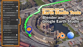
Blender Earth Modeler Add-on | 3D Google Earth (City/Terrain) inside Blender

Вставка
- Опубліковано 13 тра 2024
- #blender #googleearth
*** From Imagiscope ***
Thanks for all your interest in this add-on.
This preview shows the basic power of the platform...but... we're not done 😉. We'll keep posting updates and address the timing of the beta program many of you expressed interested in.
R
*****
New Earth Modeler for Blender! Integrate 3D models from anywhere in the world into Blender. Fast, one click modeling using Google Earth data. Get it from the source - Google Earth.
Set location and the model is imported directly into your scene.
*** NOTE ****
This is a pre-release preview of the Add-on. Stay tuned here (hint: subscribe) for details when they are available.
This project is currently in development and testing. Please feel free to contact us through the about page for information on contributing to this project.
Thanks,
Rob
Imagiscope Technology is the software developer of the Earth Modeler Add-on for Blender.
I/O announcement: • Announcing Photorealis... - Фільми й анімація


We truly don't deserve blender as a software. The gift that keeps on giving
I'm sure they would say that you deserve it because you appreciate it so much. It's a wonderful relationship and I bet the devs would love to read your comment.
I certainly don't feel like I deserve all the headaches its interface has caused me. It's like they went out of their way to make it needlessly difficult.
It's necessary against oligopolies that hold 3d hostage.
@@Corn_Pone_Flicks Compared to ZBrush or Maya, it's not even remotely as confusing. :)
You know how in every movie they explain the plans for the mission and they've got a perfect 3D model of everything they need? That's the future with Blender
As a 3D artist working in Blender for smart city production, this is purely mind blowing !
it changes everything
Can I work for you?
it opens a lot of possibilities for us!
You've been able to do this for years in blender, this add on just brings it all together.
@@Devour_ have you done it? Try working with the UVs that you get from scraping google maps with RenderDoc... it's HOURS of work. This skips that whole step. But yes, it's not totally new, agree.
big is an understatement, I've dreamt of this for almost 2 decades! Thinking back on all the projects throughout my career where a huge stressful chunk of that work could be done with a few clicks. OpenGIS itself was a godsend, but this is a "never-in-a-million-years" dream. So extremely excited, thank you for bringing this to the world!
This was already possible, altought not as fast, with renderdoc
with renderDoc you're doing photogrammetry of photogrammetry so I'd imagine there is some inherent degradation right?@@hugoantunesartwithblender
Me too, since the days of Duke Nukem and Quake 😃
Years ago i imagined an open world driving game that would utilize Google maps and census data to be able to drive and explore anywhere in the world using generative terrain, meaning that you would program the game to build the environment on the fly, along with adding in people, building interiors, etc, allowing you to just go and explore an approximation of the entire world. That sort of thing would actually be possible now.
The thing i wanna know is how do i make it a game
@@TheFERStation if I knew how to make it a game I'd have done it by now. ;)
I have dabbled in game development a tiny bit, that would be WAY over my head.
That is mostly what flight simulator does, just they used bing
This is what i've been waiting for since microsoft dropped the latest flight simulator...
It's only a matter of time.
that would be VERY intensive to run but that would be so good
Absolutely impressive!!!! I'm looking forward to test it!!!! Thanks again, Rob, you're simply the best!!!!! ❤
Can anyone give me a google api key...... i tried so many times to add my credit card and there's an error not allowing that.... I'll need it just for 10 mins.
Or if anyone can download the map and send it to me.. That would be a great help😢
Honestly might be my first time watching your channel. Great content btw.
And this is absolutely amazing. This is a game changer for blender artists. Very well done by Google. And this is just the beginning of it.
Really looking forward to this release, it's been something myself and colleagues have been interested in for years and there were some hacky or copyright infringing solutions that have come and gone over time but the fact that there is actually a partnership between Cesium & Google for this data set is critical. Thanks for all your work in this!
I see leveraging this or Cesium in Unreal with google earth tiles as overall background filler, and then having a high detailed pointcloud of the local site context, and then the 3D model of the actual architecture project being highly beneficial for AEC sector. (many other use cases as well of course)
If you go down to street level (not street view) in Google Earth, the buildings and other objects start to look kind of surreal or dream-like. For a long time, I had been thinking that, if only we could access that 3D data, it would be possible to green screen a whole movie in this surreal GoogleEarth world. With camera tracking in Blender, this can now be done. Very cool!
It was able to be done before, you were just too lazy to figure out how to do it and it wasnt even that difficult.
@@thomgizziz if it wasn't that difficult then why would Google be so proud of this new development?
@@thomgizziz wouldn't you be able to express that exact same sentiment without the unnecessary toxic hostility? Or are you just too lazy to figure out how to socially interact with other people like an adult human being with a fully formed cerebral cortex?
WOW! I can already think of a list of ways I can use this! Absolutely amazing, cannot wait to try it out!!
I LOVE IT! ❤ As part of my job (3D urban modeler), I'll need this add-on right away. I hope it will be available for download soon. Bravo for the great job.
Truly spectacular. Congratulations, this is very impressive.
I can't wait to be able to try it
I'm fascinated by the quality of the trees, cranes, billboards, etc. I use Google Earth Studio on a daily basis, and the level of detail you display is unparalleled to the original product. Take my money.
Amazing ! Cant wait for this addon to come out to the public !
This is incredible! I can imagine lots of possibilities when mixing this with the OpenStreetMap plugin. Can't wait to test it
I'm very excited for the OpenStreetMap one
AMAZING : Thank you Rob for this excellent new video. Very good demonstration !!!!! Can't wait to try it out !
Looking forward to trying this out. Amazing work to the developers.
After height maps, terrain party, Gis addon, and some other build addons since 2.78, this will be the next level.
It looks very awsome, I can't wait to try it out.
I hope it will be as great as it looks, great job guys, go Blender community!!!! 🧡🧡🧡
Can anyone give me a google api key...... i tried so many times to add my credit card and there's an error not allowing that.... I'll need it just for 10 mins.
Or if anyone can download the map and send it to me.. That would be a great help😢
I work as in an architecture firm and this is exactly what I have been looking for! We deal a lot with renderings and presenting our ideas to the clients and my sturggle is finding a good way to incorparate the design with the suraounding context. There have been many attempts to bring google images into blender but they are cumbersome and very technical. Or they simply don't work as there are many bugs (Because they are a bit complex). I would definitely be intersted in using this in every project! Great Work!
There are solutions for this particular application. The question however is if you also care for photogrammetry/topography.
Are you considering for conceptual or also in SD/DD? Maybe touring clients in the BIM model and checking what views you may get out of the windows?
Does ai do architecture yet?
@@TheBagOfHoldingConceptually maybe but I wouldn’t trust the AI to obey building and safety norms.
@@lew6598 maybe it can scan our plans and build a virtual model and test it against different catastrophic events thousands of times soon from a few prompts and scan of the blueprints at least.
@@TheBagOfHolding no... not unless somebody wants to spend a bunch of time programming it to do that. You are talking about something you understand nothing about but you feel like you do so you end up saying dumb things that you really have faith in.
this is absolutely mind blowing congratulations!! and cant wait for it to be released. Outstanding job man
This is really amazing! Greatest addon by far for cities. Can't what to see something like this for space objects!
This looks amazing! This is certainly an add-on I'd like to try. Is there a newsletter or any way to know about its development? Or maybe beta testing?
When will it be expected to become available? Utterly incredible work, well bloody done!
That's incredible!
Brilliantly demonstrated.
This is awesome. What a way to make the work flow quicker and more efficient.
That is absolutely amazing, I know some addons that can do this but here seems much much easier and with more features. Really excited for it. Any possibilities to have a beta version of the addon? I'll pay for it if it's necessary
Brilliant! I cannot wait to work with this in Blender. It will be such a time saver for quick, pre-vis environment creation .. Love it! When will the add-on be available and (of course) what is the cost?
EDIT: Quick question, when it renders out the buildings/environment, can you work on the structures as you would an asset? For example, street scene from London, could you add signage/details from an alley in Japan -or- could you add dirt and ivy/moss to the structures? Are the buildings able to be used for destruction sims or flood sims, could you assign collisions to the structures or things from the Google Earth import?
Re date: still determining. Asset usage, there are some guidelines regarding the Earth imagery that prohibits alterations, but from what I remember it's not specific. Street level detail is not great too - models are created from airplanes and shadows, trees play with the photogrammetry
Can anyone give me a google api key...... i tried so many times to add my credit card and there's an error not allowing that.... I'll need it just for 10 mins.
Or if anyone can download the map and send it to me.. That would be a great help😢
Looks really great! Can't wait to get my hands on it!
This just popped up out of nowhere. I 'm glad it did, now I have to subscribe to your channel. Great video my guy!
This looks absolutely incredible! I'm definitely interested in trying out this add-on. Is there a newsletter or any other way to stay updated on its development? Perhaps even an opportunity for beta testing?
I'll be posting here
Can anyone give me a google api key...... i tried so many times to add my credit card and there's an error not allowing that.... I'll need it just for 10 mins.
Or if anyone can download the map and send it to me.. That would be a great help😢
This is absolutely amazing, when is it supposed to be released ? Will it have a price ?
I don't have an answer yet. There are a few features that need to be developed and tested. Additionally, Google is a player here as they provide the data and I need clarification from them regarding costs, if any.
Was thinking about something like this years ago. Impressive to see it now happening.
This is amazing! I look forward to being able to get this for my own projects.
Tell us where we can download it when we can use it. That's all we care about right now. We see it's capability now We want to play
Is this add-on still under development?
This is revolutionary! Look forward to the release!
Incredible stuff, thank you Rob
why is it not linked in the description?
Its not out yet.
@lawnside82 then how is he doing or using it then
If he is able to use it then it's clearly out
Not out yet. I'm developing it. This is a preview version. Details on the beta coming soon.
@@Ponletslol the confusion
@ImagiscopeTech looking forward to its release
Still not out are you scam ?
This is crazy. I love it.
This is truly mindblowing! can't wait to test it
Looks fantastic! Looking forward to being able to try it
FANTASTIC. Great work buddy! Thank you!!
Hi, this is clearly the kind of addon I need currently. Can't wait the release !
this is mind blowing, still remember a year or so ago how to do something like is can only be done either abstract models from google, or extract the google earth studio data and try to match it in blender/ after effects. This add-on will change this workflow completely and would love to be a part of it!!
oh this is *fantastic* - can't wait to try it out!
Hello! I definitely want this add-on for Blender! I've subbed, please keep us in the loop! Thank you so much for this sir!
The all important mention of "The final render will include all of Google's legal copyright attributions" near the end.
This was the thing I wanted to hear. Excellent! Thank you!
What does "include all copyright attributions" mean?
Awesome. Definitely will be using this in my workflow. Thank you for spreading the word.
Can anyone give me a google api key...... i tried so many times to add my credit card and there's an error not allowing that.... I'll need it just for 10 mins.
Or if anyone can download the map and send it to me.. That would be a great help😢
This is out of this world! Awesome! Bravo blender!
Blender gets super charged with mind blowing addons like this!😍🔥🔥
Dang. That's incredible! Can't wait to try that out myself!
I cant wait to FINALY 3d print my home town! Its a project ive always wanted to do but never had a solid workflow for it!
looking forward to having a first release of the add-on! excellent job! I'm in through github!
Jaw-dropping! Amazing.
Spectacular, thank you very much for the development. I can think of several implementations that could add value to this functionality, especially one. Automatically creating a series of vertex groups based on the segmentation of information, such as ground, trees, buildings, etc., would be particularly useful. This would allow the use of a supplementary Digital Terrain Model (DTM) with higher quality and photogrammetric resolution, onto which the initial surface could be projected. Thank you for your attention. Best regards.
this is awesome :) great work
This is amazing! Thanks for this update Rob. Might have to sell my drone!!
This is awesome! I've been 3D printing cityscapes using Google Earth data, it requires so much fiddling and cleanup just to get the data usable using current methods, this add-on would save me so much time!
Can anyone give me a google api key...... i tried so many times to add my credit card and there's an error not allowing that.... I'll need it just for 10 mins.
Or if anyone can download the map and send it to me.. That would be a great help😢
As a London bus driver I can confirm that whenever traffic is that light it is standard practice to use the wrong side of the road. Thanks for adding that detail.
Looks amazing, would love to give a try. Good job.
This is freaking awesome
Nice job! Looking forward to see what it will become in the final release!
I tried other workflows but no one of them is very intuitive.
This looks promising!
We meet again... 😂
Can anyone give me a google api key...... i tried so many times to add my credit card and there's an error not allowing that.... I'll need it just for 10 mins.
Or if anyone can download the map and send it to me.. That would be a great help😢
Wow awesome video, I cant wait to play around with this after work!
Oh god, I would love to get this addon. Great job!
Thanks for speeding up the video! I was having trouble following along at normal speed. 🙃
I remember a few years ago following a tedious and finicky process to rip the 3D data from google maps. This is amazing.
Amazing, so many possibilities with this !
Magnificent! Congrats!
WOAAAH this is great for “generating” terrain if you want it to be as realistic as possible.
The River Thames looks so clean!
That's really cool! Now we'll have more real-life cities in games!
O...m...g... That is absolutely breathtaking! ❤
I could really use this for a project I'm working on for downtown Long Beach. Can't wait to try it.
Phenomenal! You gave us a delicious expectation, however it is unavailable! you just make us sleepless, man!
A fine artist friend once told me "To Americans, water is always blue" - He wasn't wrong. The Thames is a greeny-brown colour.
Great video, as someone who's done a dozen Earth fly-ins for clients over the last nearly 30 years, this is a complete game changer!
I was being optimistic 😉
It’s worse that his bus is driving on the right, not the left. 😂
Thank you Ton Roosendaal for freely giving the world Blender.
Wow this is really going to be helpful I really needed this feature last month took so much time to capture everything by myself with map gis for blender
Oh wow, this is pretty incredible!
Great project! Congratulatons!
Simply incredible! Can't wait for it to come out!
when this addon will be relased...?
@lubaka8269
@@redtrigger1475 No clue, the guy said he is developing it so we just have to be patient.
@@lubaka8269 ok ok
Looks great. Thanks for sharing this.
So siiiiiiiick - luv it!
Awesome work! Cant wait to try
Absolutely amazing!!
WOW!!! Grazie! 🤩
HOLY CROW YES! i have been using such a hacking workaround, this looks amazing! cant wait!!!
well, this looks simply amazing!
This is gonna be a huge deal for architectural visualization.
Crazy! How good does that look!
Cant wait for this, My Assetto Corsa tracks are gonna look amazing now
Some technological advancements can be kinda scary, but this being possible in a free 3D program is just awesome.
this is simply amazing ... wow!
Just wow kudos for this one
this is amazing and powerful.. very helpful in any birds eye view shot and any kind of wide shot
thats truly incredible!!
Let's Gooo! This is awesome.
That looks crazy good !
awesome, cant wait to try it!
Wow, this is fantastic!
amazing and I agree - mind blowing stuff!!