UPDATE: This is a pretty old video of mine and for some reason our YT overlords love it and so do you guys! The website that I used to get height/image maps doesn't really function any more so here is another to a website that functionally does the same thing: terraining.ateliernonta.com.
Hey! There is one section of this video that simply, clearly, and quickly explains something I have been looking for for weeks! It's the part where you animate the curved line! Thank you so much for so succinctly dealing with that. I'll save this video and refer to it often!
N.B.: The saved satellite view picture is not recognized by DaVinci Resolve, because it is actually a JPEG file with an PNG extension. Just fix the file extension to ".jpg" and DaVici is happy and you are good to go.
The number of subscribers dont do justice to hard work you have put. You should have more subscribers. I did my part, just subscribed. Hoping to see more DaVinci tutorials
Thank you!! I don't to much these days just because it's not something I regularly do with other projects I make but that's not to say it wont ever happen 😉
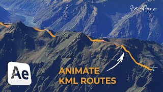
This is great! Maybe I missed it in your vid but any idea if it's possible to import a KML track into Fusion rather than manually drawing the line with the polygon mask?
Not that I'm aware of but I could be wrong. But if you wanted to, you could probably do it in Blender and from there export it into Fusion as a mesh object and that might get you what you need.
thanks for yuot tutorial, but i have a question. I dont make a polygon path, but i just have a path from a map, i overlay in photoshop and export only the line in png for put only that line in red in map, if i link at background and merge like your example didn't see the line, if i link the path media in media 1 (map satellite), all map disappear but remain only the track of path but with color and highmap of satellite image, how can I invert this and color only the PNG external like your polygon?
Thanks for making this! Really appreciate it. FYI. “Cmd D” and “type 15:00” to make the clip 15s without have to check other clip and do maths. Ctrl D on windows. Thanks again!
How does the camera angle rotate cause my one doesn't give me any angle it just doesn't move or give me any angle. Davinci Resolve 18.5 Studio version. Thank You!
Hi Aaron - An excellent video and tut, thanks so much. One question which is outside of your channel, but I am hoping you can answer and that is when I download the height maps and satellite images, I end up receiving a virus threat warning? Is this something that you may have any knowledge on? Anyway, thanks for the great video.
I've had a few other inquiries on the website not working or weird things happening. The files themselves are strange too. Being on a Mac I haven't had virus warnings, only opening them has been an issue. If it gives you too much concern for security I'd look at doing this effect in Blender with a plugin called BlenderGIS. It's far more flexible.
You could do this with blender pretty easily and almost the same way using the same image textures and displacement maps. But if your going to use Blender I would instead recommend that you look into an add-on called BlenderGIS. You'll get better 3D terrain results. I would make a video on it but for whatever reason it only plays nice with Intel chipsets. I have issues running the add-on on a M1 MacBook Pro.
I use Affinity Photo to do that. When I export I will keep the quality slider at 100%. There might be some quality loss but nothing noticeable as far as I can tell. You might be able to import TIFF images into resolve as well but I haven't tried it.
Can the map be used commercially for client project? I've read a little bit on the openstreetmap website and it seems to be fine as long as you credit the map? but I'm not sure about the "height map" part since it's from skydark website.
Weird. Never heard of that happening. Off the top of my head things to check would be the version of Resolve you're using and it also might be a difference between the studio and free version.
This is a great tutorial! Do you know if there's a way to get the polygon/line along the 3D mapping as well? This is the closest I've been getting to finding out if I could get a line moving in a 3D space (primarily the Z-axis). I've been trying to see if a line could be moved along an elevation map of sorts to get peaks and valleys, like on a Formula One 3D track graphic - something I'm trying to emulate. It seems to be such a niche thing though, or just in other programs.
I had looked into it early on when I was making this but I never came across a way to do it. It was just easier for me to print a 2D line on an already 3D displaced object in the end.
@@AaronandTaylor So I partially found out a way to do it in 3D space! Of course it would be much more work, but using Shape3D plane and the Bender3D, I think it could just about recreate the path in the 3D space! Since I'm just figuring this out, I first think about doing multiple points of Shape3D, then animating it so it flows smoothly. But maybe there's a more streamlined way to have one Shape3D node, and then (similar to a Ribbon3D tutorial I saw) have multiple points that can be curved; although I couldn't figure out how to get it to be more precise (and not loop back on itself) when messing around with it for Ribbons.
That's interesting. It seems Fusion just isn't very friendly when it comes to 3D paths. I know it can be easily done in Blender with a Bézier curve. BlenderGIS is a plugin that would allow you to get terrain data and satellite textures supper easy and I think it works a bit better than my method since it's downloading actual GIS data. I never made a video on it because the plugin doesn't work well with Apple silicon but if you're having to bend over backwards to get what you want in Fusion it might be a better option. If I were to do it in Blender I'd make a 3d path for the trail then another 3D path for the 3D camera to follow. Then have an empty located somewhere on the map that the camera always tracks to no matter where it moves. You could get some way cooler camera movement/animations out of that.
Hi, I'm very new to Davinci and Fusion. How do I change the view (not the animation) of the orbit, or Y-axis or whatever it's called. I can only rotate and zoom with my mouse. Is there a way to change the orbit view? I don't know if that made sense, I'm no native speaker. So here again in German: wie ändere ich mit der Mouse den Blickwinkel der Y-Achse in der Ansicht (nicht in der Animation)? Ich kann nur X und Z mit der Maus ändern. Danke, thanks.
@@AaronandTaylor thanks for the response. I tried that b efore - it just doesn't work. But I will find a way to deal with that. once again thank you very much, that's perfect for our travel chanel.
9:46 Instead of drawing the trail in 2D space, can you suggest how to draw it in 3D space? Meaning at the end of the 3D merge after applying height map? Reason: the height map stretches not only satellite image (desirable) but also the 2D trail (undesirable). This leads to a non-uniform trail width after applying the height map. Hope this makes sense I tried to apply trail in the 3d image using the background mask but I cannot connect background node to 3d merge. I think background is only 2d. Perhaps we can just do a pen draw direct?
That does make sense. if your 3D slope is too steep there would be noticeable distortion in the trail. Shadow Wolfe in the comments here is working on the same issue. He's further along in it than me. It would seem to me that Fusion just isn't very friendly towards 3D paths or curves so I'm not really aware of a work around. My recommendation would be to use Blender because I know you can create 3D curves/paths that would do what you want. You can also use the same resources for satellite and train data for the map or you could look into a plugin called BlenderGIS that pulls more accurate data.
Great thank you - brilliant...the moving line in 3D is a step up...however, you're still missing clamped down place labels (which stay put as you move along the path). I've never seen anyone do that yet (I've seen labels/lines on 2D maps with DaVinci, but not 3D maps..can do 3D with Google Earth Studio on AE no problem, but not in DaVinci...perhaps a limitation of DaVinci?)...I'm hoping you can give a word on that or even a tutorial. If you can do it, then I'll know there's a higher power! ; )
It’s easy enough to do in theory but I haven’t tried it. If I thought of that I’da included it in here. It’s a pretty good idea though. Do a YT search for “callouts” in fusion. Most videos show you how to do that in 2D with camera tracking on regular footage. Forget the tracking part and instead plug it into a 3D image plane node followed by a 3Dtransform node to move/scale/rotate it where you want in the 3D scene.
@@AaronandTaylor Thanks guys for the reply. The key problem I'm having, which has bedeviled many, is the tracking on 3D GES is a real toughie (at least for me and others: in AE it is automatic so it's easier). I've spoken with DaVinci experts and they confess 2D is much easier and 3D GES is uncharted terrain in DV. I'm continuing to experiment with different motion tracking options, trying to avoid getting too fiddly-faddly to keep it cost-effective. I'll try your advice above, it sounds great - thank you!
The best solution without third-party plugins is to create a dream map. But now I'm faced with the lack of an opportunity to download a map from the site using your link. How can I get around this and upload a depth map via your link?
@@AaronandTaylor Oh, this is a working link for downloading maps Thank you very much for your response. Of course, you can also use QGIS, but there is already a depth map along with the map, and there you need to cook yourself. Here, of course, it is preferable.
Great video, thank you. I have been trying to create something like this. McAfee antivirus is flagging the heightmap website as 'suspicious' and also when I tried to download the png file, it prevented me from doing so, warning that the file is dangerous and virus detected. Anyone knows why? Is it safe to download the heightmap data?
That’s very strange. It’s been a while since I’ve used it but a few others in the comments here are having issues with it too. I’d consider doing this effect in Blender with a plug-in called BlenderGIS.


UPDATE: This is a pretty old video of mine and for some reason our YT overlords love it and so do you guys! The website that I used to get height/image maps doesn't really function any more so here is another to a website that functionally does the same thing: terraining.ateliernonta.com.
Thank you for the video. Can I convert gpx (gps track) that I can import in fusion?
OMG! This is by far the easiest Fusion map tracking I've ever watched. Saving this for later. Thanks!
You're welcome!
Hey! There is one section of this video that simply, clearly, and quickly explains something I have been looking for for weeks! It's the part where you animate the curved line! Thank you so much for so succinctly dealing with that. I'll save this video and refer to it often!
Wow, that is excatly what I want to do for some of my videos. Thank you for this great tutorial.
Great work !
Thanks!!
Perfect timing to upload this one, the only good tutorial I've seen on Fusion 3D maps so far. Thanks!
No problem! Glad you liked it!!
This is by far the most accurate video for animating the map. I wish if the was a way to use gpx file instead of using polygon line
N.B.: The saved satellite view picture is not recognized by DaVinci Resolve, because it is actually a JPEG file with an PNG extension. Just fix the file extension to ".jpg" and DaVici is happy and you are good to go.
Interesting! I'm glad to finally have an explanation for that
The number of subscribers dont do justice to hard work you have put. You should have more subscribers.
I did my part, just subscribed.
Hoping to see more DaVinci tutorials
Thank you!! I don't to much these days just because it's not something I regularly do with other projects I make but that's not to say it wont ever happen 😉
@@AaronandTaylor yeah buddy you explain everything in perfect way :)
thank you so much :)
No problem!!
so true!!!
Subbed here!
One of the best ones out there. I need the skill.
This is great! Maybe I missed it in your vid but any idea if it's possible to import a KML track into Fusion rather than manually drawing the line with the polygon mask?
Not that I'm aware of but I could be wrong. But if you wanted to, you could probably do it in Blender and from there export it into Fusion as a mesh object and that might get you what you need.
website is sadly down. great tutorial tho nice work
Great work man, probably the video is in the list of very few videos where I comment. You deserver more subscribers. Hope you will get.
Much appreciated!
really helpful video mate! really nice something extra to put into travel videos
Glad you liked it!
This is a great tutorial hoooolllyyy
Glad it helped!!
Well done tutorial..thank you
No problem!!
Well thats some pretty awesome tutorial, thanks a lot!
No Problem!
wow men that was amazing did you have course for maps I can buy it?
Sadly no. This was a one off project I threw together.
Great video! thank you for sharing! Do you know if there is a way of making a larger map? heightmap has a limit of 70km map.
You'll likely want to use Blender for that with a plugin called BlenderGIS.
thanks for yuot tutorial, but i have a question. I dont make a polygon path, but i just have a path from a map, i overlay in photoshop and export only the line in png for put only that line in red in map, if i link at background and merge like your example didn't see the line, if i link the path media in media 1 (map satellite), all map disappear but remain only the track of path but with color and highmap of satellite image, how can I invert this and color only the PNG external like your polygon?
Thank you, great video.
Glad you liked it!
Thanks for making this! Really appreciate it.
FYI. “Cmd D” and “type 15:00” to make the clip 15s without have to check other clip and do maths.
Ctrl D on windows.
Thanks again!
No problem glad you liked it! Thanks for the tip too! There’s always something new to learn.
Great tutorial!! Subscribed ❤
Thanks!!
Thank you so much for this. Amazing!
You're very welcome!
How does the camera angle rotate cause my one doesn't give me any angle it just doesn't move or give me any angle. Davinci Resolve 18.5 Studio version. Thank You!
Very good. Thanks!!
Glad you liked it!
Was really helpful, thanks
Awesome!! Glad it helped.
bro... u got my like!
Glad you liked this!!
Hi Aaron - An excellent video and tut, thanks so much. One question which is outside of your channel, but I am hoping you can answer and that is when I download the height maps and satellite images, I end up receiving a virus threat warning? Is this something that you may have any knowledge on? Anyway, thanks for the great video.
I've had a few other inquiries on the website not working or weird things happening. The files themselves are strange too. Being on a Mac I haven't had virus warnings, only opening them has been an issue. If it gives you too much concern for security I'd look at doing this effect in Blender with a plugin called BlenderGIS. It's far more flexible.
great video, helpt me alot!
Glad to hear it!
Can you show us how to acheive shaded relief style map in Blender using this technique?
You could do this with blender pretty easily and almost the same way using the same image textures and displacement maps. But if your going to use Blender I would instead recommend that you look into an add-on called BlenderGIS. You'll get better 3D terrain results. I would make a video on it but for whatever reason it only plays nice with Intel chipsets. I have issues running the add-on on a M1 MacBook Pro.
I commented a bit of a workflow in another comment!
Great video ❤. Just one question🙋 need to know, how you convert png to jpeg without losing quality. Thanks
I use Affinity Photo to do that. When I export I will keep the quality slider at 100%. There might be some quality loss but nothing noticeable as far as I can tell. You might be able to import TIFF images into resolve as well but I haven't tried it.
Can the map be used commercially for client project?
I've read a little bit on the openstreetmap website and it seems to be fine as long as you credit the map? but I'm not sure about the "height map" part since it's from skydark website.
You might try this one. As far as I can tell there's no license restrictions from what I read on their GitHub page.
terraining.ateliernonta.com
have same here, my map.png is also offline when imported
I dont have fusion composition under Adjustment Clip in the effect section
Weird. Never heard of that happening. Off the top of my head things to check would be the version of Resolve you're using and it also might be a difference between the studio and free version.
@@AaronandTaylor I need the studio for this thing? I did the whole thing and at the end realize that.
This is a great tutorial! Do you know if there's a way to get the polygon/line along the 3D mapping as well? This is the closest I've been getting to finding out if I could get a line moving in a 3D space (primarily the Z-axis). I've been trying to see if a line could be moved along an elevation map of sorts to get peaks and valleys, like on a Formula One 3D track graphic - something I'm trying to emulate. It seems to be such a niche thing though, or just in other programs.
I had looked into it early on when I was making this but I never came across a way to do it. It was just easier for me to print a 2D line on an already 3D displaced object in the end.
@@AaronandTaylor So I partially found out a way to do it in 3D space!
Of course it would be much more work, but using Shape3D plane and the Bender3D, I think it could just about recreate the path in the 3D space! Since I'm just figuring this out, I first think about doing multiple points of Shape3D, then animating it so it flows smoothly. But maybe there's a more streamlined way to have one Shape3D node, and then (similar to a Ribbon3D tutorial I saw) have multiple points that can be curved; although I couldn't figure out how to get it to be more precise (and not loop back on itself) when messing around with it for Ribbons.
That's interesting. It seems Fusion just isn't very friendly when it comes to 3D paths. I know it can be easily done in Blender with a Bézier curve. BlenderGIS is a plugin that would allow you to get terrain data and satellite textures supper easy and I think it works a bit better than my method since it's downloading actual GIS data. I never made a video on it because the plugin doesn't work well with Apple silicon but if you're having to bend over backwards to get what you want in Fusion it might be a better option.
If I were to do it in Blender I'd make a 3d path for the trail then another 3D path for the 3D camera to follow. Then have an empty located somewhere on the map that the camera always tracks to no matter where it moves. You could get some way cooler camera movement/animations out of that.
Great video, thanks!
You're welcome!
can you recommend any other height map sites? skydark is being blocked by my firewall now :(
I’m not aware of any other sites but you could use a Blender to create them with a plug-in called BlenderGIS.
Hi, I'm very new to Davinci and Fusion. How do I change the view (not the animation) of the orbit, or Y-axis or whatever it's called. I can only rotate and zoom with my mouse. Is there a way to change the orbit view? I don't know if that made sense, I'm no native speaker. So here again in German:
wie ändere ich mit der Mouse den Blickwinkel der Y-Achse in der Ansicht (nicht in der Animation)? Ich kann nur X und Z mit der Maus ändern.
Danke, thanks.
Depending on if your on a Mac or PC I think you’ll want to use a key combination with the mouse with either the Option or Control key.
@@AaronandTaylor thanks for the response. I tried that b efore - it just doesn't work. But I will find a way to deal with that. once again thank you very much, that's perfect for our travel chanel.
9:46
Instead of drawing the trail in 2D space, can you suggest how to draw it in 3D space? Meaning at the end of the 3D merge after applying height map?
Reason: the height map stretches not only satellite image (desirable) but also the 2D trail (undesirable). This leads to a non-uniform trail width after applying the height map. Hope this makes sense
I tried to apply trail in the 3d image using the background mask but I cannot connect background node to 3d merge. I think background is only 2d. Perhaps we can just do a pen draw direct?
That does make sense. if your 3D slope is too steep there would be noticeable distortion in the trail. Shadow Wolfe in the comments here is working on the same issue. He's further along in it than me. It would seem to me that Fusion just isn't very friendly towards 3D paths or curves so I'm not really aware of a work around. My recommendation would be to use Blender because I know you can create 3D curves/paths that would do what you want. You can also use the same resources for satellite and train data for the map or you could look into a plugin called BlenderGIS that pulls more accurate data.
@@AaronandTaylor wow blendergis looks amazing. Especially with the 3D buildings.
respect 😎
Quality content ❤
Great thank you - brilliant...the moving line in 3D is a step up...however, you're still missing clamped down place labels (which stay put as you move along the path). I've never seen anyone do that yet (I've seen labels/lines on 2D maps with DaVinci, but not 3D maps..can do 3D with Google Earth Studio on AE no problem, but not in DaVinci...perhaps a limitation of DaVinci?)...I'm hoping you can give a word on that or even a tutorial. If you can do it, then I'll know there's a higher power! ; )
It’s easy enough to do in theory but I haven’t tried it. If I thought of that I’da included it in here. It’s a pretty good idea though. Do a YT search for “callouts” in fusion. Most videos show you how to do that in 2D with camera tracking on regular footage. Forget the tracking part and instead plug it into a 3D image plane node followed by a 3Dtransform node to move/scale/rotate it where you want in the 3D scene.
@@AaronandTaylor Thanks guys for the reply. The key problem I'm having, which has bedeviled many, is the tracking on 3D GES is a real toughie (at least for me and others: in AE it is automatic so it's easier). I've spoken with DaVinci experts and they confess 2D is much easier and 3D GES is uncharted terrain in DV. I'm continuing to experiment with different motion tracking options, trying to avoid getting too fiddly-faddly to keep it cost-effective. I'll try your advice above, it sounds great - thank you!
The best solution without third-party plugins is to create a dream map. But now I'm faced with the lack of an opportunity to download a map from the site using your link. How can I get around this and upload a depth map via your link?
Try this one.
terraining.ateliernonta.com/
You can also check out Blender with a plugin called BlenderGIS if you’re up for something more advanced.
@@AaronandTaylor Oh, this is a working link for downloading maps Thank you very much for your response. Of course, you can also use QGIS, but there is already a depth map along with the map, and there you need to cook yourself. Here, of course, it is preferable.
Great video, thank you. I have been trying to create something like this.
McAfee antivirus is flagging the heightmap website as 'suspicious' and also when I tried to download the png file, it prevented me from doing so, warning that the file is dangerous and virus detected. Anyone knows why? Is it safe to download the heightmap data?
That’s very strange. It’s been a while since I’ve used it but a few others in the comments here are having issues with it too. I’d consider doing this effect in Blender with a plug-in called BlenderGIS.
I fucking love it