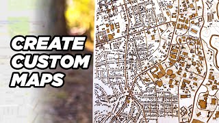
Lake Art, with LASERS!

Вставка
- Опубліковано 7 лют 2025
- Have you ever seen these laser etched and cut lake maps? Or seen laser cut maps of shorelines, or even small countries? In this video I dive in fairly deep on how to make one, or at least one way how to make one. This is the first in a few videos about these types of laser projects - so hit that subscribe button if you want to see more! Thanks, and as always - if you have any questions, suggestions, or tips - please comment down below! I do my best to answer them all!
Affiliate Links:
MDF I recommend for this laser: amzn.to/35B802Z
Birch Ply recommendation: amzn.to/35Dy0uJ
Laser I use in this video (slightly upgraded): amzn.to/35zsBEW
The same laser with Lightburn included (Definitely recommend): amzn.to/2KeEZD0
My laser rotary attachment: amzn.to/3oEDE7u
My air assist pump upgrade recommendation: amzn.to/2LkUZE9
Royalty Free Music by BenSound
One of the companies I mention in this video is Lake Art LLC. Although I have no affiliation with them, I do really like their products. Here is their website: lake-art.com
Edit: I was contacted in the comments by one of the two people I highlighted that frequently post really nice work in the forums, and I realized I should have linked them here as well. The first is Timea Ujhelyi, and his Etsy store (seems like he is on a break from it) is here: www.etsy.com/s.... The second is Peter Melis, who makes some incredible raised street maps (among other things), and I believe his work can be found here: www.etsy.com/s...
I use a site called snazzy maps, which can be found here: snazzymaps.com


This might be the best tutorial I've ever seen on UA-cam. Not just the best laser tutorial, the best tutorial period. Super professional, absolutely zero "Uh" pauses when speaking, super detailed. Yes I will need to watch it again and take notes before I attempt a lake map, but all I can say is "Wow" and thank you for taking the time to do this.
Wow, thank you very much!
Ditto
And not talking 100 mph with his rising inflection at the end so everything sounds like a question.
So easy to listen to. Subbed.
Agreed!!
agree 100 percent this video felt like i was in class
Thank you first to going through all the processes for this project. Second, the presentation is excellent. Concise and to the point.
Likin' and subscribin'! you're right about forum makers not being especially forthcoming about their process. So, THANK YOU!!
I LOVE Snazzy Maps. Just got a laser cutter for Christmas and this project is the kind of project that I wanted to tackle first. Why? Because I make real maps for a living using ArcPro and ArcMap. I have a BA and Masters in GIS. I live and breathe maps!! Especially maps with data! Great explanation on making these Laser Cut Maps! Thanks!
Smith Mtn Lake is one of our faves. Beautiful work. Greetings from 34 degrees Coastal NC.
I have spent weeks learning QGIS for potential future projects. Man that is a deep learning curve. Not to use it - that's fairly reasonable - but to set it up to effectively auto generate maps of a specific type... Just a lot of workflow stuff. Keep in touch!
This is great for this particular style, but something I've really wanted to do is build 3d layered maps based on topological data, so you have one layer per height range. I've yet to find a good source of this map data in a way that is easy to use like in this video. Any tips?
This is seriously one of the coolest laser art tutorials out there! Huge thanks for sharing!
This might be three years ago you made this but I'm just hearing it for the first time and it's GREAT. Thank-you for such a clear explanation and to top it off I am using Affinity Design as well. I have repeatedly watched and listened to your voice in each set of the process. I have made two 12 x18 maps and I am starting my third map tonight. Gave one away and sold the other! I'm in Minnesota and we have so many lakes..
Wow that is awesome!
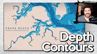
lots of man made lakes don't have good depth information, but the old elevation maps from before the dam was built are still available. Not 100% accurate, but good enough for decorative maps.
Hands down the best tutorial I’ve seen about laser map art. Thank you so much!
Glad it was helpful!
When I saw the thumbnail for this video in my suggested list, I thought this was going to be Lichtenberg art. This was a pleasant surprise! Thanks for all the information!
If you are not already narrating audio books, you should. Your diction is precise and your voice has a soothing tone, perfect for that.
Oh, and that was a great project, very well explained.
Thanks man!!!
Could you use a cnc machine for this?
Thank you for sharing!
Once I figure out how to use my laser, I'll be happy to try this out!
Excellent. 2 thumps up. 1 for the content on how you make these maps, and 2, SML is the first one I want to do. We stay there in Penhook each year. Thank you.
Such a perfect lake. :)
Well explained, and I enjoyed watching it
Wow, this lake art with lasers is absolutely epic! Been wanting to try making one for ages and this tutorial is seriously the bomb. Huge thanks for all the tips! 🌊🎨💥
I can't thank you enough for making this video and sharing the "secret" to making these types of maps! Excellent video!
You're very welcome!
Thank you for doing this, i am in a bit over my head to try this but think eventually I should get it. I started following your channel so I hope I can get a better grasp...I love the tips you've included as well... Again, thank you so much for sharing
That's awesome. Getting ready to get a laser desktop cutter and this is defiantly one of my first projects. Next to Hungry Mother, Smith Mountain State park is my favorite VA state park.
Thank you very helpful.
Big thumbs up on the video. I have got the artwork ready so I will be trying this tomorrow. I will either be very happy or sorely disappointed. But watching the video helped with getting it downloaded from the map program. I did have a few problems with the map program, a couple times I had to reset the map because no matter what I did the major road would be red and I couldn't change it no matter what I did. I then used Vectornator for composing the names and road symbols. I don't have a commercial laser cutter, only a cheap one, Ortor, but I have burned several things I've like with it. Thanks for the share, I am hoping this will be something I can add to possible selling items for the future.
I saved the video so I can go back and watch it if something doesn't turn out well. Thanks again.
Yeah, that site is very finicky…
Great video and very well explained!
Thank you!
Absolutely crazy! 💗 I love it -- Thank you for sharing.
Glad you enjoyed it!
Great video. You explained everything without rushing..
I did a show yesterday for my laser business and made $35 sucks... BUT my lake maps got crap loads of attention.
Im gonna study your vids until it is second nature to lay in the roads ..tried snazzy maps but could barely follow you, you are really quick.
But looks like Im kinda getting it. THX man
Which laser cutter did you use. Where did you get it and approximately how much? I love it!
Wow, this is a fantastic video with so much hands on instructions and a wonderful outcome! The version with the nautical depth lines is my favorite.
What I see on other channels is the usage of tape in the upper side, which helps keeping the burn stains away. Why don't you use that? Are there drawbacks?
Awesome! Your narration is really great as well, Tim.
Thanks man!
Very clear and concise.. Thank you!
I want to make the Beaufort SC area, I understand the process but need your recommendation on how to do this process when the whole area is essentially a bunch of islands.
Thanks for sharing the knowledge, this is one of the reasons I want to get into a laser cutter.
Have you ever seen Tides Out Maps version of these?? THEYRE AMAZING!!
Great tutorial. Where do you get your bathymetric information from?
Excellent walkthrough!
Thanks!!
Excellent tutorial! Is there a way to isolate trails in snazzy maps?
EXCELLENT!!! I was planning to try one but didnt know where to start. there's a lot to take in but this video is an absolute gem. Thanks again!
Thanks!
My daughter and son-in-law have a farm on SML. Can’t wait to give it a try! Thanks!
Really well done.
This is SO awesome!! I’ve been wanting to make one of these for a while and this is by far the most helpful tutorial I’ve found yet! Can’t wait to make one now. Thank you!! 🙌🏼🙌🏼🙌🏼
AWESOME AWESOME AWESOME video. I made a map within hours of watching this. Wish I could post a picture of it.
Thanks and awesome!
Has Snazzy Maps made changes? I dont see any of the options at their site. clicking roads on and off etc etc.
Thanks so much Tim! I live in a lake town and I asked all the time to make these maps. I’ve been on snazzy maps but I truly appreciate you going into depth on how to select exactly what is needed.
Dude!!! This was an awesome video. Subscribed!
Thanks for the sub!
Excellent!! I really enjoyed this. Off to try one!
FWIW:
If you align the lifferent layers before converting them to vectors, you won't have to manually align them later, they'll already be perfect. That is, if you haven't moved snazzy maps in between the exports.
Rather than exporting the layers separately for Lightburn, try giving them a different color. Should be able to export&import everything at once. If you import them, they'll be assigned to different layers automatically.
Lastly, if you can, export the files as vectors. Doesn't really make sense to export the vectors as raster, only to have to trace them to vectors again in LB.
Hope that helps. Video is great :)!
All good advice. Affinity doesn't have a trace option in it - so I need to convert prior to bringing it in. That convert - at least the software I am using, doesn't keep the original size. But if you were using Inkscape or others - you are correct. Not sure about adobe? Good tip on the color to lightburn. Never tried it. Must be the control freak in me :)
@@ThisIsHowIMadeIt i ran q test and it was pretty good. I couple if mistakes on my part with adding text and the alignmentbwas slightly off but ill get it on the next one. Probably going to run z new one this coming weekend. Question, do you seal your wood or treat it in anybway?
It looks great
One question, since we get the data from Google, can we sell it? Do we have to give credit to them?
This is great! How did you get the street numbers off the map?
This is amazing Tim!
Thanks
loved it, gonna try soon with my 5w laser haha!
Tag me when you do!
@@ThisIsHowIMadeIt yes i will do that :D, gonna finish the 3d print to lasercutter project first, but i am almost there
This is such a great video. Did you put the clear coat on before you used the alcohol to clean it? That wasn’t clear.
I don’t think I did…. Spraying one side tends to warp that thin wood…. Spraying both sides can help…
Thank you so much for this video! Could you please tell me how to Vectorize the highway numbers and symbols? Been stuck on how to do this for days!
I don’t. When I want to use highway numbers, I create them manually in my editing software. Check out the video on raised street maps of New York on my channel.
I ended up here on accident but think I am going to order a laser now :-D. Thanks for your details and smoothly rolling through the material!
Great video, very informative. Have subscribed!
Great video! But can I ask what you do with these? How do you sell them?
I have been researching this for a while how to do this for a while now. I'm so happy I came across this. This is the most detailed video I've ever came across and I appreciate your hard work
I don't see the "Image Vectorizer" on the App Store. What are you using now to convert to vector? Thanks for the video.
Still image vectorizer…. Maybe it’s just an old app not currently listed?
Awesome job! Very nice work!!
A colleague showed me a printed map which lead me down a rabbit hole ending up here. Thanks for sharing how you did it - I couldn't work it out !
Glad it was helpful!
Beautiful work, I’ve thought of doing this for some time now. Thanks for reinforcing the urge to do this in my area.
Totally impressed, just finished doing one for my lake in Maine. Have you done the same with golf courses?
Your videos are fantastic! Have my laser on the way and have quite enjoyed watching what you are upto!
Awesome, thank you!
So cool!
You're my hero!! Incredible tutorial. I appreciate it more than you can imagine 🦋🙏🦋
I am brand new to lasers so my question may be remedial, why did you use the image software to create the layers instead of building the layers and doing the sizing and manipulation of the images in lightburn?
Mostly because I wanted to edit and visualize in my graphics software, which I think is more capable than lightburn…. What I should have done is export everything in a color coded pdf into lightburn, keeping it vector to vector. I think I did that in my New York project…
I am unable to get the light to make the black and white image. I have moved the 3 lines every which way. What am I doing wrong? It seems you get the custom color to match the water color. How do I do that?
I’m not sure I understand…. Are you talking about that website?
i can not find that custom style button! where is it?
Super. Thanks!
Thank you for sharing your knowledge. This is well done.
Wow! AWESOME tutorial! I hope to make one of these with my new laser. Thank you!
Thank you! Check out the raised street map New York video for some updates too!
Thanks for your generosity in sharing 👍🏻
Thank you for sharing - too fast for me. I am having some challenges with Affinity Designer, so I was getting lost - but I know where to come back to when I know more.
You are the man!! I’m glad I stumbled on your page. New subscriber for sure, can’t wait to see what else I can learn from you.
Fantastic video. Thank you!
Glad you enjoyed it!
How did you determine which frame would have enough depth for the plywood? Which frame did you use? Thanks!
Thank you! Great tutorial. But why not put the original map on the bottom layer to align the lake and roads? Sure would beat switching back and forth to google
Well, because I didn’t think about it. Sounds like an amazing plan!
do you have an amazon link for the frames?
Great video friend. Explained like a professional..... Thumbs up..... :)).....
Thank you! Cheers!
Fantastic work, thanks for sharing. Awesome
oh woh! I came from Roanoke O_O this hit home hard @_@
My new primary channel. You are rock, man! Great video!
Thanks!!
Great VO.
Thanks for this great video!
Thanks Tim, this video is really helpful.
Phenomenal instruction! Just what I was looking for. Thanks for sharing!
Thank you!!!!
So glad I found this
This is an absolutely awesome video. I've been wanting to make a lake map for a family member but couldn't figure out how to get started. I think I've watched this video nd your Florid Keys video at least 12 times each and I think I learn something new every time I watch it. One question: When labeling the roads and POIs, what size font have you found works best for readability, without overpowering the map?
Thanks Mark! I did some testing on the key west one for size, and I think I found I could get good readability at a 6 font size when doing a vector engrave. So I do 6 font for streets, and 8 for POI...
@@ThisIsHowIMadeIt Thank you for the quick response
Hey thanks, Tim, this is fantastic! I am going to a friend's cottage this summer and want to create a similar project for them!
Love your teaching style and the pace you go. Well done. Have you ever done this in 3D and if so, could you do a video on that as well? Great work.
Very well done
great video!! how did you do the contour line portion, though? On your tray? thanks
Meaning how did I cut the lake out? I put the wood on brass picture hangers for stand offs, and taped it flat…
Where have you been!! Great videos!
Great Video. Have you ever tried painting the "land" surface? The MDF I have is a little darker...
I made a map of Middle Earth and almost painted the land area but ended up staining it ..boy was I glad I did, came out great (I think)
Painting it is good. I use 3M tape so it's not so burnt when you do the final cut. Then you can just wash it was a wet cloth
this does not work for me. I select my location and when I hit the style it keeps going back to New York
Great informative video thank you for sharing the information1
Very nice video. Your skills, voice and techniques are superb. I will try to make my own version as soon as my laser arrives and I become familiar with it. I just subscribed and will be viewing your other videos as I can. Thanks!!
Nice job, Is that the China blue and white laser? I also use the brass picture hangers to lift my stock
It is. It’s an Orion motor tech from amazon...
I see you have made some of your digital files available in your etsy store. Would you consider making this on available. I would love to make this for my RV, starting with a known good project before I make my own.
I would be glad to, but I’m not sure I even have the original artwork anymore. I’m in the middle of a shop love and am not set back up yet. When I get going I’ll look!
Do you know if snazzy maps also has bathymetric data available?
Oops just caught it at the end of your Video lol
Yeah, google maps does not, and there is no easy resource for lakes. I think most people find a picture or a nautical chart, and trace the lines they want over it.
congratulations on the beautiful work, which program recommends using vector images just like you did
I use Affinity Designer as the main program. I convert images to vector on a Mac by using Image Vectorizer. There is an online version of that as well.
nice video , but this map dose not show water body depths , like you references and idea how can i get them ?
Check my key west video