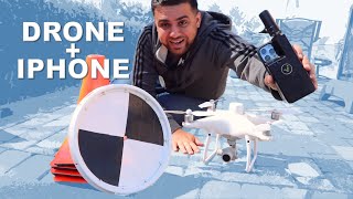
iPhone 13 Pro LiDAR vs. Survey Total Station Accuracy

Вставка
- Опубліковано 9 лип 2024
- Interested in attending GEOWEEK 2023? Use code RAMI100 for $100 off a conference pass OR a free exhibit hall pass.
Sign up here - invt.io/1ixbktqnxjp
Join The Survey School - thesurveyschool.com/
👕 Shirts - www.SurveyShirts.com
Today we measured the accuracy of the iPhone 13 Pro's LiDAR Sensor by comparing it to measurements of a surveying total station. THE RESULTS WILL SHOCK YOU!
Download 3D Scanner App - www.3dscannerapp.com/surveying
Chapters:
0:00 Intro
1:12 Analyzing Project Site
2:58 Surveying with the Total Station
7:09 Scanning with iPhone 13 Pro
9:59 Importing Data
13:15 Feature Extraction
16:10 Comparing Coordinates
19:43 Outro
Join me on Social Media:
🖥️ Website: www.tamimi.biz
👥 Private Facebook Group: / iamasurveyor
📸 Instagram: / ramitamimi
👔 LinkedIn: / ramitamimi
✉️ Email: rami@tamimi.biz
About Professor Rami Tamimi:
Rami Tamimi is an American doctorate student at The Ohio State University working towards his Doctor of Philosophy in Geodetic Engineering. With over 8 years of experience in the Land Development Industry, his experience revolves around traditional field surveying, civil design work using AutoCAD Civil 3D, and geospatial technology including LiDAR, SONOR, and Photogrammetric data accusation and processing with the use of Unmanned Aircraft Systems or Drones. He is also a University Professor and creates instructional video content on UA-cam.
#Surveying #iPhone13Pro #LiDAR - Наука та технологія


For a hands free mapping those are huge results, really good data.
Yes, the results are fascinating for something like this!
Pretty impressive accuracy for a tiny sensor in consumer hardware. I’m a Geotech engineer. I can think of a few cases where that could be handy.
There is always a great application for every tool. Glad to see more engineers are finding value in this one!
I believe lidar is being considered by nasa for mars exploration
@@RamiTamimi I drive lorries and I sometimes double check the height of a lorry before going under bridge or trough narrow gate and so far have not been dissapointed using measuring tool built in iphone 12 pro max
I’ve been making some crazy architectural diagrams with the LiDAR feature. Had it first on my iPad a year or 2 ago and blew some of my tutors minds back on my degree.
Me, too. Wish I had this thing 20 years ago when we were measuring a route for a new sewage pipe - 10km long, 2m wide, doing it with just a total station and no GPS. That LiDAR thing accuracy would have been way enough and time spent on measuring a fracture of what we took.
For ball park measurements calculating building materials required, this is accurate enough. For scanning between known fixed points, it is also good enough to generate a profile. Given that the maximum range is only 5 metres, you are pushing against the accuracy limits anyway. Pretty impressive performance from the iPhone given it is not mounted on a tripod with a fixed remote reference point.
💯
We tried it and we're off by 8.6 inches over a paltry 61 feet. Worst part was that if we hadn't checked our work with a laser scanner, we wouldn't have known that we were that far off.
If that's "in the ballpark", that's an awfully big ballpark.
@@chrislutes2882 as was said, it’s accuracy is 5m, not 61ft 😂
This is ideal for indoor mapping more than anything, scanning small rooms etc, not for large scale work, that’s not what it’s designed for.
This is exactly what I searched! A comparison between a professional and the new iPhone LiDAR sensor.
Awesome, hope you liked it and learned from it~!
I once had to set a bunch of stakes on a property line for my girlfriend…. It was a pretty complicated property line, with odd arcs and angles and set on a steep hillside. I took a plat map of the property and used my iPhone for bearings and a laser ruler to measure starting from a boundary marker. I used a construction app to correct for elevation based upon measured angles to each stake as it went up the hill and calculating the base off the hypotenuse. And double checked with the GPS receiver on the phone for elevation changes. For arcs I set a stake at the center of radius and just measured off the stake to mark out the curves. The neighbor decided to hire a surveyor to check the property line and the surveyor found every one of my stakes to be within an inch of the true property line. He asked me how I did it and was astonished that I could figure it out with nothing but an iPhone and a laser ruler. iPhones are essentially tricorders.
please make a video
@@peanutbutterpadre1519 That was 7 years ago. And I’m not with her anymore…. But even 7 years ago, you could use an iPhone to ascertain bearings and read GPS elevations. I used an app called Theodolite. If you have one known point in the form of a boundary marker, you just measure distances and bearings as listed on the map. The only hard part is correcting for elevation as the plat map is a flat projection. But the property map had topographic lines and numerous bench marks noted for verifying elevation. By averaging the GPS elevation measure with the nearest benchmarked elevation, I could derive a hypotenuse length based upon the plat map distance and measure up the hill that distance ( when you’re doing it on your own, you need a bright surface to target the laser ruler on and you need a laser ruler that can handle the 200 plus feet you’ll need to measure. So you plant a target at a known point and walk the bearing until you get the distance you’re looking for. ) You can double check your elevation estimate by measuring the angle to the prior known target with the iPhone’s inclinometer and deriving how much higher than the target you are with the same Pythagorean calculation. Then you go back down and fetch your target and relocate it to the new known point. My target was literally a length of galvanized electrical conduit with a piece of stiff white board on it with an X at exactly my eye height above a hole with a bolt thru it drilled perpendicular thru the pipe about 18” up the conduit and I would drive the thing into the ground with a short length of larger water pipe slid over the conduit until the bolt I was banging against was at grade- using the iPhone to make sure it was plumb. This way I am measuring from my eye height thru the iPhone to a target that is my eye height above grade. I literally used an improvised plumb bob to transfer the position of the iPhone to the ground. ( holding the upper end of the string in my left hand just below the lens of the iPhone ) As you compile points, If something is significantly off, you run a do over. Over plotting a whole bunch of points, you can tell if you’re on track by the cumulative error. It took a lot of traipsing up and down the hill, resetting stakes and target to correct for cumulative error… but overall errors over and under true measure tended to average out. For example, I would stake maybe 6 points along what the map showed as a straight line… and then sight back along them and correct to the mean line of sight that was on the correct bearing.
I knew I was on track when my plotting placed me within a few inches of a corner marker hidden under a bush that I didn’t even know was there.
All in all, it gave me profound respect for the guys who had surveyed the first ‘accurate’ height of Everest, by starting at sea level in India and working their way across hundreds of miles using nothing but a theodolite and slide rule. I would not use this technique to survey unknown ground, But with the backup of a plat and topographical map with known points you can cross reference, you can plot a property line reasonably well.
This guy is great. A true nerd, but I think we can all relate.
@@calebwallace9589 right?! I just appreciate videos to see their method in action to see if I can find good ideas to apply to my projects.
@@christopherpardell4418 thanks for taking the time to detail and share this, well done mate!
Just wondering, would having the phone attached to a gimbal like the Osmo help with accuracy? I can imagine a certain % of error could be due to shaky hands.
Great video idea!!!
i was thinking the same thing while watching this video.
Buen punto
It might help a little bit but the pull rate of the sensors (gyro, compass, accelerometer) in the phone seem to be high enough to easily calculate out pretty much any shaking in processing. It’s really impressive for such a small device and I wouldn’t have thought that it would actually be that accurate before watching the video
Short answer is no.
I’m genuinely impressed how many ways you tested this within a 30’ long area of sidewalk and gutter.
Congrats. That's a very good presentation you made here. Keep up the good work. Thank you
This is awesome review, thanks for sharing!
Amazing! thanks for you video!
Thank you for posting this content!
It's a very good video! Congrat's Rami! We listent a lot of think about the lidar of the iphone and your comparaison is exactly what and landsurveyor search! Thanks a lot and keep going, you do a very good job!
Thank you. Very detailed.
Great, thanks for sharing this comparison,
Nicely done. Really helpful to see the lidar accuracy. Thanks.
Thanx for this !
Incredibly valuable information! thanks
Great informative video, love the comparison and much appreciate the effort to do the work from a fellow Surveyor, thanks Rami!!
Glad you enjoyed it!
Best video, i adore your content. Keep feeding us with ( technology, new equipments of Surveying and process of work for whole your 10 years experience ) much thanks bro
thanks ....great work
Such a good video !!!
I greatly appreciate your videos, very informative and delivered in a way a layman can understand!
I’ve been in the heavy equipment grading side of construction for over twenty years. The company I work for recently invested into gps technology, I’m the sole operator, I hope to train more, of the gps grader, rover, and I make our maps via Trimble business center. My previous experience with grading was laser with a grade rod. You have helped me tremendously with filling gaps of knowledge I was missing. It’s hard sometimes to ask a question when you don’t even know how ask it, much less even know your missing key knowledge lol. I look at brochures and promotional videos of the equipment we have to grow questions to look up. There’s not much info on UA-cam for this line of work.
I really hope your channel gets traction and gains in popularity, I know it’s a big time suck to make these informative videos but please keep up the great work!
Thanks Kenny. I love making these videos, and having this be my full time job would be a pleasure!
Thanks for the video, I found it very interesting
very good video!!
Good job!!!
Congrats for this video
Rami, this is an excellent video, I'm glad I've found your channel.
Thats excellent merci
Thank you sir for your efforts..
Banger video bruv
I am impressed with the accuracy of the iPhone-generated point cloud, especially considering the phone was not positioned or moved in a controlled manner. To take it to the next level, the LIDAR app could recognize objects placed on several KNOWN precise control points (as done in the video), the known exact locations of those (2 or more) control points would then be loaded into the app, and the app would apply corrections to all the data based on knowing several exact actual positions within the data. Probably could be worded better. End result would be quite accurate surface data using the iPhone sensor in conjunction with the total station or an RTK system.
It might be possible to use GPS for that.
Great work! I would love to see the efficacy of this on a larger scale. As a landscape architect this could be extremely useful
Amazing video!!!
Really good video, congratulations.
Great work done. I appreciate your efforts thanks.
Much appreciated!
Muito obrigado pela comparação. Foi um vídeo muito esclarecedor.
Man! Incredibly good!! Thanks for doing this video with such a great quality on edition and all the effort you put on this is awesome. Congratulations and thanks for sharing, I'm civil engineer from Colombia and videos like this help people around the whole world to understand better how this new technology is going into the game! Keep up the great job!
تجربه حلوة يا رامي التميمي .. تحياتي
really awesome video.
That's thorough !!
Very informative.
Sir I like your Video. Please tell me exporting format from the 3d scanner app. Which type? Plz
Really nice comparison. This portability and accuracy for visual effects is amazing.
Excellent demonstration. You really did put a lot into this video and it shows and for someone like me that hasn't Really seen a lot of this, it was a very good video and it taught me a lot thank you
Thank you, that means a lot!!!!
Great effort, appreciate 👍
It's my pleasure
Great experiment! Thanks!
Thank you! Cheers!
I appreciate your hard work behind the video
Thank you for the video. I have all of the corner pins of my property marked. is a string accurate enough to use to set a fence on the 628'boundary line or would you use an instrument of some type?
This is a wonderful video. Very thorough. Tom marks dear sir.
This was a pretty awesome video
Rami excellent work! Just a few quick questions.
1. When Aligning the point cloud to the total station points if you use 2 points (1 plane, X) is that introducing error in the Y plane with 3 points (2 planes) could you balance both X and Y? The Z axis between points looks way closer that the Delta Averages by your chart just wondering if there might be drift between Gyro Level in Phone and total station level.
2. If you scanned say a 1"X1"X1" cube in the LiDAR data would it help with the scaling issues importing to CAD?
Thank you, very good content !
You are welcome!
good video. Remember that good survey practice is to have your backsight as the furthest point away from your detail survey.... if possible to avoid angle error. Also you had high vertical angle readings, so RL error would be higher. Would be good to see your next video on this.
helpful tutorial videos for surveyors.. keep it up.
Starting to use ArcGIS heavy for work and this is exactly the content I was looking for. Subbing for sure.
Very interesting
Thank you! 😀
No problem 😊
Hello and congratulations on the channel, I wanted to ask you if I should recommend a device between iPhone and iPad 11 pro which one would you recommend me to make a survey through a cloud of points with lidar technology? Obviously I am not interested in having a millimeter precision, I know that in this field we need a professional instrumentation. Thank you
Very good analysis. It was helpful, since I have been thinking to buy leica BLK 360, I see for generating rough existing plans with +/- 100mm accuracy this is great. Thanks man.
Well done video. does the iPhone export the pointcloud as a rcs file? or do you do that in another software?
I'm a newb to this topic, so very appreciative of the time and effort put into this video. 💥💥💥
Awesome videos, I use Carlson Point Cloud to analyze the point cloud data.
I do have a question, in the video I see that you bring in a .rcs file into C3D, yet I don't see that file extension in the app to export to, did you use Recap to do the conversion?
Dear Sir, i had a question how you save it in .rcs format as I m new to ladar survey in order to download it to civil 3d.
As a new real-estate agent in AZ, where so-called "mustang subdivisions" are scattered all over the place, having a strong understanding of surveying only helps our potential buyers to identify risks and possibilities BEFORE they sign a contract...
Also, would love to see same comparison, but using the Matterport Pro2 camera system.
Hi Rami thanks for the good content ! Why are there no point cloud or model for the scan done with the stations ?
Could you generate a mesh out of the survey station ? And overlap it with the iPhone mesh ?
Thanks
Thank you Rami, you are an educator.
Amazing and can site exclamation an example thank you!
Cool video! Thanks for sharing!
I can’t unsee the crooked globe on the light above the dining room table. :)
Rami, this is the first video I’ve seen of yours and i found it to be fantastic.
I’m not a surveyor, nor even in the construction industry. However, I do watch a lot of home building, construction, excavation, and concrete videos, so thats probably why your video came into my feed.
This was so well explained I was able to follow and understand the whole process despite never having used either the survey tools nor an iPhone 13.
Here are some thoughts I had.
1.) The Total Station obviously has a lot of advantages afforded to it, for example, it’s fixed position. The biggest advantage, however, I think would be the prism.
2.) While there will be movement induced inaccuracies from the LiDAR sensor and accelerometers in the iPhone, I think there may be resolution and backscatter inaccuracies in the point cloud.
3.) A set of inexpensive markers could be made with a bubble level and some object the LiDAR could accurately key off of (a small orange ping-pong ball, steel ball bearing, 6-sided die? obv. testing needed).
4.) With an effective marker in place, the survey points in the point cloud would jump out and we can subtract the marker’s height from the measured elevation.
In theory, i think this would reduce the prism’s advantages, and some other’s suggestions like using a gimbal or a weighted steady-cam could help reduce motion induced error.
Thanks for the great video! definitely sub’d. 👍🏻
Diddo.
Great video. I wonder if there's any performance difference between the different apps on the iPhone.
Interesting project and discussion. Watching from the Philippines.
Very nice
Good points
Nicely done bro..
how did you convert the point cloud to rcp format? what app did you use?
Nice video
I’m a real estate lawyer and actually had an appointed expert-surveyor in a case take a LiDAR scan with his iPad Pro, to scribble notes on and take rudimentary measurements from. And all the (many) parties asked about the app and how he did it. It was so funny.
Hello Rami, I’m using Civil 3D 2018 but in the ‘Attach Point Cloud’ option in the Insert menu I cannot import .las file that I export with my iPhone 😢
Thanks bud
Really enjoyed your video and found it very insightful.
Would be great to see how the accuracy would be if you use the exact points once you import it.
Thanks for the metric really helps
Question, how can I get a 1 foot topographic interval DWG file from my 3-D scanner app on my iPhone 12 max pro?
Awesome
Yes, yes very well done indeed. Very emotional!.
Surely you need three alignment points for a 3D dataset, or your elevations will be off for all but the two alignment points and anything directly between them.
Impresionante!
Cool video
I'm saving your channel .in my folder.
Beautiful minds ☝
How did you export the point cloud in "rcs" form? Or how did you change it to that format after exporting in a different form?
Incredible.
Rami , what if you use with Iphone DJI + Posisioning point sticker (which ussualy used for 3d scaner )?
regunto: es posible con esta aplicacion que el movil recalcule el punto de scaneo,para asi descartar el error por variacion de punto fijo de escaneo ?
Hello. Work with measurement of indoor environments for woodworking. In your opinion, would the iphone have the necessary precision to measure a kitchen or a room?
Good work 👍
Thanks ✌️
What do you recommend for a PC to start learning CAD and TBC?
Hi Rami, for laying out let's say 10 studs of 2x4 lumber for scanning in a set jig, and then design for CNC/CAM, would the Apple lidar scan to .5mm or lower accuracy?
oooo! I want that motorized position finder for my telescope.. thx 4 the idea. I was using a vice+hammer+protractor
Nice video man
Glad you enjoyed
Thanks for the informative vid. I'm using a SOKKIA ix Robot with Carlson Surveyor+ for survey work. When I loose the prism lock I have to push the "Search" button on RC-PR5A to resume it. How can I use the Data Logger to do it? Also I feel my Carlson Surveyor+ is much slover than your Allegro 2.
Thank you for the video before I study in a college or in a university next year.
Great content, as other surveyors already pointed out you should transform with minimum 3 points, preferably with a helmert transformation / smallest square method. Thanks for taking the time making this comparison and thanks for using mm.
Regards, a Swedish Surveyor
Hello, I am a surveyor from Russia. Can you tell us how a typical surveyor's day goes in Sweden?
Excellent, you are a bright young man. Keep it up.
Thank you so much 😀