The instructions came in handy for my project on GeoHECRAS too. And it's integrated with Civil 3D so the project completed faster. Thanks for sharing the video!
Hello, so in civil 3d when I am sitting at a lower chainage and looking towards a point of higher chainage, the features on the left side of me will appear on which side in the cross section generated by Civil 3D?
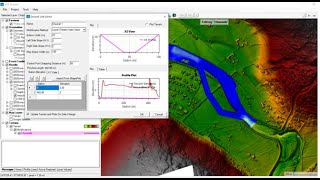
I was able to export the surface but now I see two different grounds on cross sections..one is proposed and the other one is existing. I want the model to run in proposed terrian but it runs with existing one I am doing all these to compare water surface elevation of proposed and existing condition as a part of flood study,


The instructions came in handy for my project on GeoHECRAS too. And it's integrated with Civil 3D so the project completed faster. Thanks for sharing the video!
You're welcome.
I'm from Indonesia, really helped your tutorial in my thesis research ...
Thank you for sharing..
Very Nice. You are extremely talented.
Thank you sanyam, now I learnt to determine flood range
Welcome, didn't you face any problems?
@@SanyamGhimire no I didn't face any problem
Could you make a video on river mixing with a tributary river too
yeah, I hope I would get enough time to make that too..
Hello, so in civil 3d when I am sitting at a lower chainage and looking towards a point of higher chainage, the features on the left side of me will appear on which side in the cross section generated by Civil 3D?
Upstream is at higher chainage and downstream is at lower chainage in hecras. But its opposite in Civil 3D.
@@SanyamGhimire In civil 3D, I think it is our choice to assume the direction of chainage. Am i Right?
@@theteddychannel2770 You have to flip the chainage manually in HecRas after importing it from civil 3D
Ras Mapper option Manage Result Map is not activated in my case. Why? Can you help me!
update your hecras to the latest version. I think Hecras 6.0 available now.
Thanks, It works well.
bro surface matra export garna mailcha hecras ma? not crosss section line just terrian from cad to hecras
Yes of course.. just follow the later steps..
I was able to export the surface but now I see two different grounds on cross sections..one is proposed and the other one is existing. I want the model to run in proposed terrian but it runs with existing one
I am doing all these to compare water surface elevation of proposed and existing condition as a part of flood study,
May i have this tutorial file? Hec ras and civil 3d?
esto es una joya
Thanks, It works well.