It should be helpful if you may clarify that precipitation boundary condition considers a time series of rainfall excesses (effective precipitation). Thank you for your video.
What a nice work! I do learn a lot on you. But, would you mind show us how to use the "Meteorological Data" tool and import raster data? There is less example on it. I think lot of people like me wonder in it, thank you for your sharing!
Ana, dado que cuando hacemos estos modelos en zonas aterrazadas se generan numerosas manchas (charcos) en las pendientes que van en dirección contraria al drenaje ( las terrazas tienen una pendiente invertida a la pendiente natural de la ladera), cómo podemos corregir esto? porque realmente son zonas que van a acumular agua pero no tienen una velocidad de flujo (solo en el punto de entrada y salida de agua). ¿A partir de qué velocidades podemos considerar despreciable? Existe alguna forma de corregir este fenómeno o demostrar que dichas zonas no son críticas a la hora de construir (más allá de que pueda quedar el agua encharcada un tiempo, no son riadas).
Hi Ana, i use hec-ras to modelling a runoff and i have water in the corner of every cell. My question is, why the water do not transit in the downstream? And does this have an impact on the flow at the outlet? What can I do to improve this? I use SWE (faster). Thanks for your help bye
Depende si utilizas la capa de infiltración dentro del modelo o no. La lluvia neta es la bruta - perdidas, en he podemos introducir perdidas por varios métodos, por ejemplo el SCS
Hello , I have 2 questions... 1- Is it possible to do 1D Ras Mapper modeling using rain as input data in HEC-RAS...? 2- Is it possible to use the Curve Number (CN) in 1D/2D modeling in HEC-RAS...? If you have any documents or videos, please share them with me... THANKS🙏
Hey, Happy to see this quick video. I tried to follow the same except for that courant value , I have fixed base , rest all same. But I cannot visualise any results in Ras mapper even though results are updated in layers . Do you have any idea on it?
Hi actually my precipitation data had a starting value of 20 mm and I forgot assign a base value of flood plain, this made Hecras to run on null data simulations or false one.
Hi, I am not sure if there are specific tools for this.l My suggestion is to create a 2d connection, and use programming or tricks to evacuate this water
READ_UN_MET_PRECI 233 Read_UN_Met.for Error with program,when i run the official example about grid precipitation(use meteorologcial data).How could i solve it?
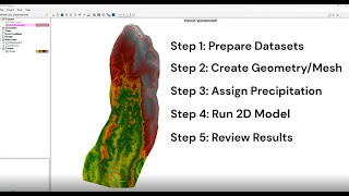
Hi, in this tutorial we are showing how to do a precipitation model with infiltration layer, we do not focus in other model considerations such as roughness coeficient, input terrain, mesh design, or equation set and calculations. But roughness is surely a parameter to be taken into account in modeling.


Many videos had title as inundation mapping but was showcasing floodplain mapping , Thanks for concise tutorial on inundation mapping !
This is a great video and actually shows how to import single point (rainfall gage) data and not just gridded data! Great job!
It should be helpful if you may clarify that precipitation boundary condition considers a time series of rainfall excesses (effective precipitation). Thank you for your video.
Thanks for this quick tutorial, I love it❤
Thank you very much! Much appreciated! It worked just fine ❤
What a nice work! I do learn a lot on you. But, would you mind show us how to use the "Meteorological Data" tool and import raster data? There is less example on it. I think lot of people like me wonder in it, thank you for your sharing!
Very good work
Ana, dado que cuando hacemos estos modelos en zonas aterrazadas se generan numerosas manchas (charcos) en las pendientes que van en dirección contraria al drenaje ( las terrazas tienen una pendiente invertida a la pendiente natural de la ladera), cómo podemos corregir esto? porque realmente son zonas que van a acumular agua pero no tienen una velocidad de flujo (solo en el punto de entrada y salida de agua). ¿A partir de qué velocidades podemos considerar despreciable? Existe alguna forma de corregir este fenómeno o demostrar que dichas zonas no son críticas a la hora de construir (más allá de que pueda quedar el agua encharcada un tiempo, no son riadas).
Thank for this tutorial❤
great work
Hi, thank you for your video. Is this simulation based on the Hortononian model to simulate runoff over land?
Gracias
Hi Ana, i use hec-ras to modelling a runoff and i have water in the corner of every cell. My question is, why the water do not transit in the downstream? And does this have an impact on the flow at the outlet?
What can I do to improve this?
I use SWE (faster).
Thanks for your help
bye
una consulta en la herramienta de precipitation del programa. Cual es la que se debe poner la precipitación neta(precipitacion en exceso)
Depende si utilizas la capa de infiltración dentro del modelo o no. La lluvia neta es la bruta - perdidas, en he podemos introducir perdidas por varios métodos, por ejemplo el SCS
THANK YOU
Thanks a lot
Hello , I have 2 questions...
1- Is it possible to do 1D Ras Mapper modeling using rain as input data in HEC-RAS...?
2- Is it possible to use the Curve Number (CN) in 1D/2D modeling in HEC-RAS...?
If you have any documents or videos, please share them with me...
THANKS🙏
I have not done 2d model with this parameters, but maybe it is possible
Hey, Happy to see this quick video. I tried to follow the same except for that courant value , I have fixed base , rest all same. But I cannot visualise any results in Ras mapper even though results are updated in layers .
Do you have any idea on it?
Move the time botton or prex max value. Are you sure time are correct and it has computed hydraulic results?
Hi actually my precipitation data had a starting value of 20 mm and I forgot assign a base value of flood plain, this made Hecras to run on null data simulations or false one.
Hi how can I add a an artificial drainage and calculate total volume of water that accumulates in its outfall in this model?
Hi, I am not sure if there are specific tools for this.l My suggestion is to create a 2d connection, and use programming or tricks to evacuate this water
Hi. How can we add an outlet for the rainfall runoff?
But this analysis depends in the slope and depth area . Raining 🌧 analysis need Sattlite imgery depending on day raining
READ_UN_MET_PRECI 233 Read_UN_Met.for Error with program,when i run the official example about grid precipitation(use meteorologcial data).How could i solve it?
Why you not considered about the manning co efficient??
Hi, in this tutorial we are showing how to do a precipitation model with infiltration layer, we do not focus in other model considerations such as roughness coeficient, input terrain, mesh design, or equation set and calculations. But roughness is surely a parameter to be taken into account in modeling.
por favor aclareme esta duda
Hola Omar, que duda?
Thank you very much for your video, it really helped me a lot. Can you share the data used in the video?
hello mam. where can I get the reference layer? the .shp file. thanks
Hei Tinio, I dont have this files anymore sorry, but you can create them in ArcMap, Qgis, GlobalMapper... or even in RasMapper now
@@anajuarezgomez690 how about the precipitation data? can you teach me how to do that? please