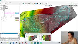
1D Flood Simulation Model in HEC RAS: Steady Flow Analysis

Вставка
- Опубліковано 8 лют 2025
- Tutorial on 1D Flood Simulation Model in HEC RAS. In this case Steady Flow Analysis will be performed.
👉 Udemy course at ₹499 from (22 -29 Oct 2022) 👈 Link: cutt.ly/qBMXjFu
******************************************************************
You can CHECK this OUT !!
BUY Domain at Cheap Price!! : cutt.ly/5CEuzSD
🌎 GIS Work|| Best laptop at Low cost!!
Acer Predator Helios: amzn.to/3MzpjWM
ASUS TUF Gaming: amzn.to/3CwUpti
Lenovo Legion: amzn.to/3g87HEW
MSI Stealth: amzn.to/3CX9qWH
MSI GV15: amzn.to/3EHtSfM
Acer Nitro: amzn.to/3CBJLSh
******************************************************************
*Course with Certificate at $9 only!*
MS Excel Online Training - cutt.ly/uBx2Pc1
******************************************************************
Find More Tutorials:
Land Cover Data 10 m Resolution: • Download ESRI 2020 Lat...
Least Cost Path: • Multi Criteria Based L...
Download Open street Map: • Download Open street M...
Stream Power Index SPI Calculation: • Stream Power Index SPI...
Topographic Wetness Index TWI Calculation: • Topographic Wetness In...
Suitability Analysis Using Arcgis: • Suitability Analysis U...
Add xy data from excel, clip, select, split, table select tools in ArcGIS: • ArcGIS Basic Part 2: A...
Drainage or Stream Frequency & Infiltration number: • Drainage or Stream Fre...
Calculate Stream or Drainage Density: • How to Calculate Strea...
Extracting Stream or Drainage Network from DEM: • Extracting Stream or D...
Detail Watershed Delineation using DEM: • Detail Watershed Delin...
ArcGIS Tutorial: • Calculating Chlorophyl...
Qgis Tutorial: • Calculating SAVI MSAV...
Change Detection: • Hotspot / Kernel Densi...
Download Free Shapefile: • Download GIS Shapefile...
Download Soil Organic Carbon, Evapotranspiration, Land cover, Precipitation Data: • How to Download Soil O...
Human Influence Calculation: • Human Influence Calcu...
Lineaments Extraction : • Lineaments Extraction ...
World Soil Map Shapefile: • Download World Soil Ma...
Hotspot / Kernel Density Analysis: • Hotspot / Kernel Densi...
GIS Shapefile Data ( Road, Structure, etc.) for Any Country: • Download GIS Shapefile...
Land Cover Change Detection: • Land Cover Change Dete...
Soil Moisture Index and Land Surface Temperature Calculation: • Video
Calculate normalized burn ratio (NBR): • How to calculate norma...
Create Specific & Random Points: • Create Specific & Rand...
Keyword: flood simulation free,flood simulation model,flash flood simulation,flood map,interactive flood map,hec-ras 5.0.1,2d flood modelling,2d flood, hecras, hec ras software
Contact if need
Facebook: / rsgistutorial
Twitter: / rsexplore
Linkdin: / siam-khan-89236a1b9


Amazing video, was working on GeoHECRAS ; and this really helped me out. Thanks for sharing!
Superbly done
Buy 👉Highest rated👈 with learningProfessional Certificatelearning|| GIS Course from Udemy : cutt.ly/148TX5U
Get Certified! IT Certification courses starting from👉👉 ₹499
End Date: 06-30-2023 07:00 GMT 👉👉Link: cutt.ly/5wq2VJJ1
Hi, I find your video very helpful. Is it possible if I want to get the word document you show in this video?
Sir can it be done on landsat image because my water body is in three different districts and DEM.. So i am working by mosaic the three DEM.... And there are many errors and i can't complete the process its giving so many errors....
Please upload 2d steady and unsteady flow videos also.very informative.thank you
Will upload soon. Thanks for watching madam
Please provide word document which you have presented
@@204-wre-chukkaangelina7 Please submit your email address madam.
chukkaangelinagrace9@gmail.com
@@204-wre-chukkaangelina7 Check the email
hi sir, while entering Manning's n or k value, for me n#1 is editable but n#2 and n#3 is not editable. what is the cause of this? if there will be any problem because of this to the model?
SIR, The terrain centre line elevation in the graph for the river in my study area is showing very high values.But in actual case ,the river is lying in low lying area.Is there any mistake?
Either Topography data having poor resolution or recheck the Survey levels 😅
I have a doubt sir, how you calculate the water flow from cross section for 5 year and 10 year?
From Frequency analysis
If you need the data for exercise; Please submit your email in the comment
i need info about the software HEC RAS, mquinta.1986@gmail.com
where I download it? Thanks!
@ Its free software. find it from this website: www.hec.usace.army.mil/software/hec-ras/download.aspx
Please check your email for the data. thanks a lot for watching sir.
please share me the data for exercise, my email : hendra.achiar2020@gmail.com , thank you.
@@hendraachiari2183 please check your email sir.
I need info about the software HEC RAS and this data. imranak32@uok.edu.pk
May I have a copy of the word document that you used in the video please.
Sure.. Please comment your email address here.
I have doubts sir....could u plz reply....I did exactly as shown in video bt I'm getting error...as right bank values not entered
Do you set the projection system correctly?
@@ExploreRSGISTutorials I need to learn plz give me some way to contact u....I tried adding my mail ID bt it's getting deleted
@@Rohan_s9 Send email at planner.islam123@gmail.com
hello, is it possible to get the doc. document
Sure, Please submit your email here.
Hi, can you send me the word document?
Please provide word document which you have presented
Sure, Please submit your email here.
I wanna learn...I'll pay u can u teach....I have doubts
Where you face the problem?
What is the meaning if we get negative or zero values when we draw cross-section for our study area?
You can check this madam: cutt.ly/fWlLV8q
mam exactly same error are shown in my project will you please provide me solution.
@@niteshgehlot1119 Try to perform daily then this error doesn't happen.I did the same almost after a week I could get it.Follow the procedure of this video only.Might be some problem with server of the software.
@@204-wre-chukkaangelina7 Ok thanx
Hi, can you send me the word document?
Sorry , I lost it.