Lost Cove Wilderness Study Area - Wilson Creek - Pisgah NF NC | 3-day Backpacking Report

Вставка
- Опубліковано 4 жов 2024
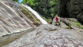
- This is the full length trip report with natural sounds and on-trail commentary from a 3-day backpacking adventure that I took to the Lost Cove Wilderness Study Area in June 2020. I covered ~11 miles and caught a few trout on this hybrid backpacking/fishing trip in the Wilson Creek area of North Carolina's Pisgah National Forest.
I explored Gragg Prong and Lost Cove Creek with a jaunt up to Bee Mountain in between the two river systems. The 2 nights on this trip were the 2 most beautiful campsites I stayed in during the first half of 2020.
Highlight Video set to music:
• Lost Cove Wilderness S...


New intro! Hope y'all like it as much as I do
We watched your video, packed the packs and went straight to Hunt Fish Falls! What an incredible area, absolutely beautiful. Just wanted to let you know that your efforts to share these places really do make a few of us motor! Thank you. Happy hiking.
Thank you very much for sharing Lori, that means a lot to me. Glad y’all got to enjoy this special area! Keep it up 🥾
Great video and also very helpful in backpacking the area. I just did my 2nd overnight backpack there (Tuesday and Wednesday); the other backpack was in 2002 and it hasn't changed much. We started at the Roseborough Trailhead and understand your comments about the trails being "a little confusing" as there are numerous trails and misleading signs. Indeed the signs and the trail numbers need updating, especially on the maps. Your map showed a trail (# 262) going directly south to the Timber Ridge Trail, whereas it's not even shown on most maps. And the trail numbers are inconsistent on various maps. But relying on your video we took the good trail from the Roseborough Trailhead to Timber Ridge, then Timber Ridge Trail east to Lost Cove Creek, then up Gragg Prong a very short way and we camped at exactly the same spot you stayed at (totally by chance, did not realize it until looking at your video again after our trip) and like you said it was a perfect campsite (there were 5 of us, 4 tents). Next day we went on up Gragg Prong to the starting trailhead, a wonderful section of trail with so many waterfalls. We all concluded that the hike from Hunt Fish Falls to Gragg Prong Falls and on to the Roseborough Trailhead is one of the top scenic trails in the southeast for sure, probably top 5 for me.
Awesome Will! Glad you had a good trip on your 2nd time out. My fingers are crossed that it won't be 19 more years until your 3rd.
I appreciate you sharing that the video helped you explore the area. I try to walk a fine line between providing enough information to be helpful but not hand holding or taking away the sense of adventure for someone who wants to do it on their own.
There really is incredible beauty through that stretch. Great that you got to experience it, thanks for taking the time to share this comment.
Nice trip report. I hope this area is able to obtain Wilderness status. Glad you were able to catch some trout! Would like to see more of that in your vids.
Thanks OO! This area was recommended for Wilderness status in the 2023 Pisgah Land Management Plan but needs a congressional act to lock it in. It’s always fun fishing, I love to do it.
I'm a couple of years behind, but, I'll binge watch to catch up to Jan 2024. Glad I found your channel!
Better late than never Craig! Glad to have you around. Lots of adventures to binge, enjoy!
We just found it too! So far we did this hike, after watching, looking forward to the next.
The new intro is pretty cool and unique! This looks like a pretty chill place with all the creeks.
Thanks Nate! You’re right, it was a super chill place.
Thanks for the map information.
Great choice for a hike.
🇺🇸
You’re right AD, this is a great hike
Great video! Thanks for showing this great hiking trail.
Thank you Nealie. Unfortunately 1000 acres in this area just burned at the end of December
Daughter and I are doing this very trail in a few weeks!!!! Thanks.
Awesome Peter, good luck & happy trails to y’all!
Excellent video, looks like a great time.
Thanks John, it was a great time out there
Oh my goodness! That little animated intro made me smile. Lol.
I love the map explanations you do. So helpful! I definitely want to check this area out now.
Thanks Seagrass! I appreciate you sharing that you find the maps helpful, those are typically the most skipped scenes in my videos. The Wilson Creek area is definitely worth checking out if you like water, that Linville Gorge site I shared with you also has good maps for the Wilson Creek backcountry
New Intro! GREAT! Love it man.
Thanks tn, good to hear from you!
Really cool new intro. Great trip vid!
Thanks for sharing your thoughts on the intro X! Glad to see it is being well received
Great video - I've been to Hunt Fish and spotted the loop on the map - wanted more info (have to research before hitting the trial with a bundh of scuts) and this was perfect!
Good luck to you and your scouts Keith!
Beautiful area and very cool video :)
Appreciate the support Wonderer!
Really enjoyed your trip report! Love to backpack & fish and always looking for routes to combine the two.
Thanks for watching Mike! The Wilson Creek area is rife with backpacking & fishing opportunities, I am hoping to explore more here in the future.
Again, another great video! Really enjoyed watching this and I guess maybe wishing it could have continued. That is a great area and other areas close by. Don't know if you had the time to visit Big Lost Cove Cliffs up the road on the right from where you parked or Little Lost Cove Cliffs on the left. The Little Lost Cove Cliffs has a loop, so to speak. At the lower end, if one walks out the trail below the LLCC's trail, there are remains of an old chimney. The lower end of the LLCC trail passes through and old apple orchard which bears had nearly destroyed one tree climbing to get the apples. The old RR rails you saw on the trail are, as you mentioned, are scattered through out the area from old logging operations (narrow gage RR's). A number of different loggers were in our mountain areas and Ritter Lumber was one of those. They had a logging camp at Mortimer and was responsible for the development of that little community. Lot's of information available on Ritter in old news papers. Thanks again for sharing this experience and "happy trails to you again".
Thanks for watching Jerry! You're right, this is a great area and I hope to explore more nearby in the future. I didn't see either of those Cliffs but did come across a cliff-like structure on the Lost Cove Loop Trail. Thanks for sharing these pieces of history around the remnants and Ritter Lumber! Happy Trails to you too
Another great video, Layne! Your production quality is getting better all the time!!
Thanks buddy! Practice makes perfect and I strive to improve with each video. Looks like you survived your BMT attempt, hope that went well for you!
@@LayneComfort Indeed it did. Check out the video on Sidneyhornblower's channel.
Fun video! 20 days, what an awesome adventure
Great video report of the area! Where along the loop was your first campsite?
Thanks Jacob! I break down each day on the map so it should give you a general idea of the campsite locations
I love the quote and your videos buddy. What kind of mic do you use?
Thanks RJ! I use the built-in mic that the camera has
I am looking for info on this trail like where to park and maybe even a map. I am looking forward to trying this out please and thank you
Hey John there are two maps I recommend. For a paper map Pisgah Map Co’s Grandfather Ranger District map. For your phone the free Wilson Creek / Lost Cove / Harper Creek map download for the free Avenza app. Good luck out there!
I live about 10 miles away from wilsons creek me and my family spend our summers on the creek every year
Awesome Katherine, beautiful place to live
Do you stay at a campground or dispersed site? I thought I saw a section with dispersed sites but am not sure.
Out on this loop in Lost Cove it is all dispersed camping. There are some campgrounds elsewhere in the Wilson Creek area
Where exactly is the two swimming holes you came across first on the video
Hey Felix, I couldn’t call it at this point. The daily map shots should help narrow it down to a few miles of trail. Good luck exploring!
I found the place it was very nice
Awesome, nice work Felix!
what's the regulations for fishing on this trail! i am struggling to find info!
There are different regulations for different creeks on this hike. Lost Cove Creek & Gragg Prong are the major fishable waterways. The NCPAWS site has regulations broken down: www.ncpaws.org/ncwrcmaps/fishingareas
@@LayneComfort so basically from the looks of it you can only catch and release in lost creek trail? And then gragg prong you can catch and cook?
Bead Mtn OR Ned Mtn?
‘Bee’ Mountain!
@@LayneComfort ahh, yes. You are correct.....😀
Do you have a map and trip itinerary?
You can get by with the free Wilson Creek map download on the free Avenza app but I also show a paper map and each day's itinerary in the video!
Sorry about that. I need to watch the whole video before I ask questions.😂
No worries, thanks for the comments! The daily map breakdown of the route should help but don’t hesitate to reach back out if any questions persist