Black Mountain Crest Trail - "The Death March" SB6K Ep. 8

Вставка
- Опубліковано 10 вер 2019
- I started Day 2 at the Bowlen Creek parking lot and set out to hike the Black Mountain Crest Trail also known as "The Death March".
The start of this trail up to Horse Rock Meadow is around 4.5 miles with an elevation gain of just over 3000 feet. There aren't any views along this section of the trail. Once I reached the meadow I was greeted by a friendly brown snake.
From there I found the manway that leads to the summit of Celo Knob. It was pretty straight forward in finding the wooden sign and the geo marker. I snapped a few photos and headed back to the Crest Trail.
There wasn't any views due to it being a socked-in day. So I continued on to my next summit which is Gibbs Mountain. This summit was also an off-trail section. I had to scramble around some low limbs and up a huge rock and back a little further to get to the top. There is no view here just trees.
Back on the Crest Trail, I headed for Winter Star Mountain this is where the trail changed from being a ridgeline hike in the grass to more of a trail of ups and downs. There were sections of the trail throughout the day that required a rope to either get down or get up the trail. Once at Winter Star Mountain I snapped a few photos and ate my first lunch. This summit is right on the trail. For me it was on my right side headed toward Mitchell.
Next up was Cat Tail peak. NOTE that there is a faint trail that leads up to the summit where there is a geo marker. Once back on the Crest Trail I passed a wooden sign that read Summit of Cattail Peak. THIS IS NOT THE REAL SUMMIT!
From there you'll go down into Deep Gap and Big Tom Gap, Both are very hard climbing out. Balsam Cone was my next SB6K peak. Luckily this summit is right on the trail.
Once I got to Big Tom I thought I was going to die. what a climb there were two sections of ropes that helped me climb up the trail. This is the first time all day that I've seen any other human or talked to anyone. I needed the breather break.
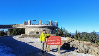
Next up the second tallest mountain east of the Mississippi Mt Craig. Once I got there I knew that I had about a mile left. I snapped a few photos and ate a few snacks and drank some water. still no views. From there it was on to Mt Mitchell.
I can't believe I was doing this...joy just filled my soul. omg omg omg...ha
and there it was the parking lot of Mt Mitchell. So why not add one more summit to the day so on up to the top of Mt Mitchell for my seventh summit of the day.
I bought a dr pepper and changed shirts, socks and put on my toboggan and waiting for my shuttle to take me back to my truck.
Just a wow of a day! I will definitely hike this again. Hopefully next time I'll have some views.
I hope you're enjoying these South Beyond series videos. If you do please consider subscribing to my channel. Also, press that "Bell Notification" so that you don't miss any future videos.
My very best,
Johnny
SUBSCRIBE and learn about the Great Smoky Mountains or hiking and backpacking in general,
with an occasional cycling video or two.
/ @johnnyonthetrail
Lets Connect!
- / johnnyonthetrail
- / johnnyonthetrail
- sites.google.com/view/johnnyo...
- / kf4pch
- johnnyonthetrail@gmail.com
Johnny on the Trail
1471 West Millers Cove Road
Walland, TN 37886
MY HIKING & BACKPACKING VLOGGING CHANNEL
- / johnnyonthetrail
I want to thank everyone who has supported this channel. I'm
grateful that you choose to support me with your viewership and
time. I hope that I'm giving my audience exactly what they want to see.
with a promise of no clickbait or misleading thumbnails.
I am open to suggestions for content so drop me a comment and let me know what you are interested in seeing. I will be traveling more this year so
expect to see some new hiking/backpacking locations other than the Smokies.
*******************************
Camera: GoPro Hero and iCamera X
Gimble: DJI Osmo II
Video editing: Filmora


Please consider SUBSCRIBING if you like all things adventure.
This trail is right up with the following; the Presidental Traverse, the Great Range Traverse of The Adirondacks, and the Devil's Path in the Catskills. And maybe the Enchantments?
Good to know, those are on my list as well.
"Think I've made up my own cuss words." 😂 Love this video, Johnny and especially seeing that big smile on your face at the end! So informative and definitely looks like a suffer fest!! I'm doing it in a couple of weeks with a good friend who is visiting from Colorado (and is an amazing athlete) so I'm a little nervous about keeping up with him after watching this! Glad you got through and nabbed all those peaks too--you rock! :-)
Hope and Feather Travels it’s an amazing hike I just wish that i had clear skies. But...I will hike it again. Yes I was so happy to have hiked it.
Thanks getting ready to do in early April when its a little bit warmer and no snow on the ground. Very helpful informative video. Thanks for posting.
Awesome Enjoy it. I want to do it again when there are clear views. It was such a fun and challenging hike. Thanks for reaching out.
i'm envious. i hiked from mitchell to craig, thats about all i could handle. lol good job
Teresa hikes Thank you. That whole trail is a beast. You still did well. Lots of elevation.
Awesome video! Heading that way in a week to hike opposite way Mitchell to Bowlens. Thanks for great video!
Awesome, you’ll love it. Lots of ups and down. Hopefully you’ll have some great views. Enjoy every step.
Great video....love the intro....(stay humble and kind🎶🎵🎶🎵 )💗
Thats exactly right... Stay humble and kind, I've got mountains to climb.
Johnny on the Trail 💖
I just finished this trail and loved it. Started at bolens creek late in the evening and hiked up to woody ridge before sunset roughly 4.2 miles. The next day I hiked to mt mitchell then back to bolens creek. Roughly a 20 mile day in 9.5 hours. This trail was tough but easier than I was expecting. Even had to yell at a bear in the middle of the night sniffing around my tarp. Great times!
Oh my gosh, gotta love those curious bears. glad that it didn't take anything from camp. Yes that hike up Bolens to Celo was tough. But once at the top it wasn't too bad. sounds like you have a great hike. I'm hoping to get a redo soon.
Tough trail and great video!
Thank you, It was a tough trail but very rewarding. great solo hike.
Great job on this video! I’ve done it a couple times and plan to hit it again next month... enjoyed hiking along with you on this video.
Thanks for joining me. I believe I'll be hiking this route again in the upcoming months for a podcast or maybe film thing. I'm unsure of the complete details. This is a beautiful hike.
Get it brother!You tackled that beast.....great video.
Thank you! It was a fun day.
Did you end the hike at the Mt Mitchell parking lot right near the summit. Looking to do this exact hike and want to make sure if I get picked up at the Mitchell lot that it would count towards the SB6K. Thanks!
Yes that’s where I ended that hike. Those first few miles from Bowlen creek were rough.
Nice video! That's place is beautiful! Hopefully I can get out that way one day and get some footage of the on to put up own the channel.
Love this video what kind video equip you useing
Thank you John! I generally use a GoPro Hero 7, sometimes my Iphone Xs, and DJI Gimbal. various tripods and a creative mind.
Hey there! Does it look like there are spots you can hammock at deep gap?
Hey, would you be able to provide me your GPS track. Did the death march last week and couldn't find cattail peak. Didn't want to get lost when I was tired and gave up on Cattail peak. Guess I've got to do it again just for 1 peak. Will do it starting from mount Mitchell next time though.
of course i can send me your email or PM me on IG or FB.
Come to renegade mtn😊
Where is that? Tell me more...
@@JohnnyontheTrail heynow. It is in Crab Orchard TN. A couple vids here. Some towns people don’t come here cause they believe its haunted.
Oh this sounds like it's right up my ally. I think i've been there long ago. I went over and rode some single track dirtbike trails years ago. We parked on the right side heading west and rode across i40 and somewhere over on the left side we hit the woods. it was a lot of fun.