Exceptional lecture, very well organized and keeping to the point. It's actually a lot easier to follow the entire lecture (almost 1.5 hours) than most people might think. Thanks a lot!
tastic teaching with top notch drawing and hand writing skills!Really happy that I stumbled on to this and now finally understand the GPS plus. Thanks Dr. Medeiros and University of Central Florida for sharing such well presented teaching that goes on there at your University
Absolutely one of the most educational and well presented videos I have watched!! I like another viewer wished that the stuff in the field had been filmed :) I now have a MUCH better understanding on GPS and RTK in general. Thank you very much!!
I've been in surveying my whole career of about 20 years now and I've never felt like I've understood this stuff until right now, what an amazing display of intelligence and great explanation.
Wooow..am just 5mins into the video playback but i have understood something i have never learned/heard from anywhere/anybody in the past prior to this video. Is a well delivered class. Great job Dr. Medeiros. We need more of such videos
Fantastic teaching with top notch drawing and hand writing skills!Really happy that I stumbled on to this and now finally understand the GPS plus. Thanks Dr. Medeiros and University of Central Florida for sharing such well presented teaching that goes on there at your University.
YOU BEEN I BIG BLESSING TO ME. YOU HAVE A TALENT TO EXPLAIN AND TEACH SOMETHING SO HARD I A WAY THAT I UNDERSTAND IT. GOD BLESS YOU AND YOUR FAMILY AND CAREER.
The material given from this video is practical enough for a civil engineer to do a simply topograhic survey by himself without the help from third party (saves plenty of time without the needs for setting out control points at remote area by total station) ±20mm horizontal and ±40mm vertical for RTK is sufficient for general purpose. Thank you for the lecture.
Thank you very much for publishing this information. I am using Pix4D in conjunction with aerial photos taken with my drone to produce orthomosaics. I understand the process, but in the three courses I have taken, very little explanation is provided on how to obtain the GPS data.
Yes, this is a good general overview of GPS fundamentals but the explanation of how RTK works is wrong. At around 48:00, he mentions that the base station transmits a "delta" so the rover can correct its coordinates. Actually, the base station transmits its raw carrier phase observations to the rover so it can process the relative vector from the base by double differencing.
this topic on land surveying is phenomenal by the lecturer who indeed understand land surveying and what it takes be one. i wish to have him as friend so things will be in other in surveying. but want him to tell me is it possible to plotts coordinate on Google earth pro. please keep me posted on lands surveying.
The base position is not a known position at all. It's.just a constant position that can be used to process a relative position from the base to the rover.. 47:07.
I think you can't know the distance of the device to the satellite just by listening one signal, because your device does not know the correct time. So to what would it be comparing that received pseudo random number at 10:00, it it doesn't know the correct time? I think it needs to receive more signals, to get the clock in he device corrected?
Yeah, he kind of blew the gps explanation. He actually means pseudoranges. It is a range that only means something when compared to other pseudoranges. You could tell your distance to sat 12 is 1000 meters farther than to sat 14, but you don't know the actual absolute range. You have to have pseudoranges to (at least) 4 satellites in order to solve for the 4 unknowns of x,y,z and time. That's your position and time.
At 33:57 he states that (10123, 459344) shows 10,123 meters north and not east. Is this not (East, North) just like an (x,y)? He states the Northing first, and the Easting second.
13:35 "shift by 2 numbers can tell you the time difference" well how do you know if the shift is by 2 numbers or by ENTIRE_SEQUENCE+2numbers? or generally by N_TIMES*ENTIRE_SEQUENCE+2numbers?
I believe it is first matched on the pseudo random number, then it goes down to the precision code ranging. I didnt search for this, it is just what makes sense for me.
Because the entire Precision PRN sequence is actually very, very long. It takes 266 days to send the whole sequence before it repeats, so there is no ambiguity. The C/A code is much shorter and repeats every millisecond.
What do you mean when you say(1:09:47) you were able to " cut out a little piece of the geoid" for your project site? how do we create this localized area?
if you downloaded the entire earth Geoid, your file may be too big to work with in your data collector. With software or online services through NGS you can create files that contain the Geoid information only for the area/region you are working in.
Someone probably already made this comment, but cell phones do not get additional position data from a “WiFi” signal, they get that information from a cellular signal. They try to refine your position by determining your distance from the cellular tower you are connected to.
so is this a class for free or can i sign up for this? btw the presenter looked a little nervous but i kinda understand now just need more confidence in his speech..
This video needs some corrections. At 1:30 he says "...maintained by the United States Air Force". The GPS constellation is both maintained and operated by the United States Air Force. Kinda Nit-picking? Well lets go on... At 1:45 he mentions "27 GPS satellites" (space vehicles); there are actually more than that in orbit, and the constellation performance requirements are based on a constellation of 24 available space vehicles, not 27. At 1:57 he says ..."wherever you're standing each satellite will pass over your head twice in a day", and at 2:30 he draws a depiction of GPS orbits and mentions "orbital planes". One of the planes he draws is a polar orbit. Be advised that the inclination for ALL of the GPS space vehicle orbits is the same, and it is 55 degrees. Importantly: between 55 deg north latitude and the north pole and 55 deg south latitude and the south pole NO GPS space vehicles ever pass overhead. Thus precision of GPS solutions for users in those latitudes degrades as they get closer to each respective pole. All you have to do is Google "GPS orbit inclination" to confirm that. Given 3+ strikes in less than 3 minutes, and you can Google to get more reliable information: I'm not wasting any more time watching this.
Amazing crash course on GPS Surveying. What's with people and thinking they can just pick up their phone call in the middle of lecture? 55:05. Learn how to respect, lady.
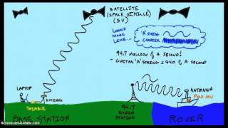
+Juan Carlos Montes Herrera It's kind of complicated but the short version is. You have two GPS receivers on the ground, and they receive signal from the same satellite vehicles, however many that is. So you have vectors going from the ground receivers to the Sv's. You then take the difference of the difference (double difference) of these vectors and the resultant is a 3 dimensional vector between the receivers. Since we know the location of the base we can place the tail of the vector on the known point and the tip of the vector is the location of the Rover. This entire process is calculated in real-time by the processor in the receiver. the information transmitted by the base is simply the GPS information it receives.
i like how the students asked him questions to clarify how a gps reciever would know when the signal started in order to find the difference between the time when it was sent and the time it was recieved and he just kept pointing at his dumbass explanation on the board that displayed literally zero math and expected everyone to just nod their heads as if it was a sufficient explanation....
speaking of measuring elevation, Why can I measure the elevation at sea level and I can measure the elevation of the mountain top and every foot in between but I can not measure the 8" per mile squared according to the pythagorean theorum of geometry and spheres for earth to be a spinning ball with a circumference of 24,901 miles let me tell you all why EARTH is FLAT


Exceptional lecture, very well organized and keeping to the point. It's actually a lot easier to follow the entire lecture (almost 1.5 hours) than most people might think. Thanks a lot!
tastic teaching with top notch drawing and hand writing skills!Really happy that I stumbled on to this and now finally understand the GPS plus. Thanks Dr. Medeiros and University of Central Florida for sharing such well presented teaching that goes on there at your University
Absolutely one of the most educational and well presented videos I have watched!! I like another viewer wished that the stuff in the field had been filmed :) I now have a MUCH better understanding on GPS and RTK in general. Thank you very much!!
I've been in surveying my whole career of about 20 years now and I've never felt like I've understood this stuff until right now, what an amazing display of intelligence and great explanation.
Wooow..am just 5mins into the video playback but i have understood something i have never learned/heard from anywhere/anybody in the past prior to this video. Is a well delivered class. Great job Dr. Medeiros. We need more of such videos
Fantastic teaching with top notch drawing and hand writing skills!Really happy that I stumbled on to this and now finally understand the GPS plus. Thanks Dr. Medeiros and University of Central Florida for sharing such well presented teaching that goes on there at your University.
The content was extremely well delivered. A highly informative video which answered many questions I had regarding the use of RTK systems.
YOU BEEN I BIG BLESSING TO ME. YOU HAVE A TALENT TO EXPLAIN AND TEACH SOMETHING SO HARD I A WAY THAT I UNDERSTAND IT. GOD BLESS YOU AND YOUR FAMILY AND CAREER.
Thank you Dr. Great information and well put together.
Very well delivered talk on surveying. Very concise and to the point.
Awesome video. The guy teaching was excellent. Thank you to whoever posted this. 👊🏻
I love the lecture, so much detailed and i am really pleasured to have the chance to watch it.
In a few minutes I learned so much. Thanks and greetings from Panama, Central America
The material given from this video is practical enough for a civil engineer to do a simply topograhic survey by himself without the help from third party (saves plenty of time without the needs for setting out control points at remote area by total station) ±20mm horizontal and ±40mm vertical for RTK is sufficient for general purpose. Thank you for the lecture.
Brian Ho what generally purpose could you be talking about? ground shots??
Engineers.... always thinking they can be surveyors too :P
the best talk I have heard about gnss, congratulations, from mexico
I was just listening and not looking at my screen and said to myself he sounds like S Medeiros. I used to work with you. Very informative video.
Excellent presentation
Great lecture
Excellent intro to GNSS, thank you so much for sharing
Extremely best lesson. boosts my knowledge as a surveyor in Kenya
Hey bro how can we connect? I'm a Surveyor from Uaganda
Fantastic presentation. Simple but quite informative
thank you very much, that was extremely helpful. hope to find another land surveying workshop videos very soon on this channel
Thanks for the presentation. Very well explained & demonstrated.
Very good lecture, and great overview of the GPS fundamentals.
This is fantastic
Thank you very much for publishing this information. I am using Pix4D in conjunction with aerial photos taken with my drone to produce orthomosaics. I understand the process, but in the three courses I have taken, very little explanation is provided on how to obtain the GPS data.
Yes, this is a good general overview of GPS fundamentals but the explanation of how RTK works is wrong. At around 48:00, he mentions that the base station transmits a "delta" so the rover can correct its coordinates. Actually, the base station transmits its raw carrier phase observations to the rover so it can process the relative vector from the base by double differencing.
Very good presentation!
Well delivered!
Clarify many things specially in rtk
I wish you filmed on field too
Any how keep it up!
which minutes
This topic of land surveys is important for one to learn from this lecture.
im only 5 minutes into this lecture and really loving it.
Jesus. I’m the opposite. I’m 5 mins and my eyes are about fall out of my head haha.
But I do need to know this boring crap.
This is very good and detailed presentation.
Wonderful! Thanks Dr. Medeiros
I have learned a lot from this lesson, thank you very much sir
Where else can I find videos like these?
Thank you for the presentation. I enjoyed and learned quite bit.
Well delivered information. However, is it common in USA, answer the phone middle of session?55:04 Even it’s not silent mod lol
Superb!
Thanks, Watching from Bangladesh. It's very helpfull for us
this topic on land surveying is phenomenal by the lecturer who indeed understand land surveying and what it takes be one. i wish to have him as friend so things will be in other in surveying. but want him to tell me is it possible to plotts coordinate on Google earth pro. please keep me posted on lands surveying.
The base position is not a known position at all. It's.just a constant position that can be used to process a relative position from the base to the rover.. 47:07.
I think you can't know the distance of the device to the satellite just by listening one signal, because your device does not know the correct time. So to what would it be comparing that received pseudo random number at 10:00, it it doesn't know the correct time?
I think it needs to receive more signals, to get the clock in he device corrected?
what about carrier range?
Yeah, he kind of blew the gps explanation. He actually means pseudoranges. It is a range that only means something when compared to other pseudoranges. You could tell your distance to sat 12 is 1000 meters farther than to sat 14, but you don't know the actual absolute range. You have to have pseudoranges to (at least) 4 satellites in order to solve for the 4 unknowns of x,y,z and time. That's your position and time.
At 33:57 he states that (10123, 459344) shows 10,123 meters north and not east. Is this not (East, North) just like an (x,y)? He states the Northing first, and the Easting second.
Very NICE video, very well done.
Nice and helpful lecture.
Hi. Can you do a video for static method?
great video, very helpful.
I hope sir that you could explain to us the static mode in GPS and how to observe points with static methods.
Much appreciated.
A nice piece ,how can i have this software.GPSRTK cost .
Very good info.
Very useful for technical students
Can't thank you enough!
13:35
"shift by 2 numbers can tell you the time difference"
well how do you know if the shift is by 2 numbers or by ENTIRE_SEQUENCE+2numbers?
or generally by N_TIMES*ENTIRE_SEQUENCE+2numbers?
I believe it is first matched on the pseudo random number, then it goes down to the precision code ranging. I didnt search for this, it is just what makes sense for me.
Because the entire Precision PRN sequence is actually very, very long. It takes 266 days to send the whole sequence before it repeats, so there is no ambiguity. The C/A code is much shorter and repeats every millisecond.
I am interested the workshop
THANK YOU
What do you mean when you say(1:09:47) you were able to " cut out a little piece of the geoid" for your project site? how do we create this localized area?
if you downloaded the entire earth Geoid, your file may be too big to work with in your data collector. With software or online services through NGS you can create files that contain the Geoid information only for the area/region you are working in.
nice well done
Thanks, Great Informations
Someone probably already made this comment, but cell phones do not get additional position data from a “WiFi” signal, they get that information from a cellular signal. They try to refine your position by determining your distance from the cellular tower you are connected to.
Hey bro.im a land surveying student from Uaganda.How can we work together please
This is what I need
so is this a class for free or can i sign up for this? btw the presenter looked a little nervous but i kinda understand now just need more confidence in his speech..
Very good perspiration, Thank you
This video needs some corrections. At 1:30 he says "...maintained by the United States Air Force". The GPS constellation is both maintained and operated by the United States Air Force. Kinda Nit-picking? Well lets go on... At 1:45 he mentions "27 GPS satellites" (space vehicles); there are actually more than that in orbit, and the constellation performance requirements are based on a constellation of 24 available space vehicles, not 27. At 1:57 he says ..."wherever you're standing each satellite will pass over your head twice in a day", and at 2:30 he draws a depiction of GPS orbits and mentions "orbital planes". One of the planes he draws is a polar orbit. Be advised that the inclination for ALL of the GPS space vehicle orbits is the same, and it is 55 degrees. Importantly: between 55 deg north latitude and the north pole and 55 deg south latitude and the south pole NO GPS space vehicles ever pass overhead. Thus precision of GPS solutions for users in those latitudes degrades as they get closer to each respective pole. All you have to do is Google "GPS orbit inclination" to confirm that. Given 3+ strikes in less than 3 minutes, and you can Google to get more reliable information: I'm not wasting any more time watching this.
I think Chris is lecturing
Amazing crash course on GPS Surveying. What's with people and thinking they can just pick up their phone call in the middle of lecture? 55:05. Learn how to respect, lady.
GNSS is a generic term....we are using RTK for property surveys...
The explanation for how the RTK solution is derived is completely false.
Could you elaborate or share a correct explanation :)
+Juan Carlos Montes Herrera It's kind of complicated but the short version is. You have two GPS receivers on the ground, and they receive signal from the same satellite vehicles, however many that is. So you have vectors going from the ground receivers to the Sv's. You then take the difference of the difference (double difference) of these vectors and the resultant is a 3 dimensional vector between the receivers. Since we know the location of the base we can place the tail of the vector on the known point and the tip of the vector is the location of the Rover. This entire process is calculated in real-time by the processor in the receiver. the information transmitted by the base is simply the GPS information it receives.
Excellent, thank you very much!
Thank you for the clarification, I will be sure to update the material in future lectures.
i like how the students asked him questions to clarify how a gps reciever would know when the signal started in order to find the difference between the time when it was sent and the time it was recieved and he just kept pointing at his dumbass explanation on the board that displayed literally zero math and expected everyone to just nod their heads as if it was a sufficient explanation....
speaking of measuring elevation, Why can I measure the elevation at sea level and I can measure the elevation of the mountain top and every foot in between but I can not measure the 8" per mile squared according to the pythagorean theorum of geometry and spheres for earth to be a spinning ball with a circumference of 24,901 miles let me tell you all why EARTH is FLAT
In Rem mainly because you're an idiot.
que bueno seria traducción en español
This is a terrible explanation of how gps works.
THIS IS ENOUGH ....
Only could watch for 2 minutes. Extremely poor audio.
This lecture goes veeeery sloowly and is very primitive.
I'd expect better from a university.
I think Chris is lecturing