
- 15
- 236 538
UCF IAHR
Приєднався 20 лют 2014
Відео


IAHR Seminar Fall 2015 - Presented by Lei Yang from Southwest Florida Water Management District 2
Переглядів 888 років тому
IAHR Seminar Fall 2015 - Presented by Lei Yang from Southwest Florida Water Management District 2

IAHR Seminar Fall 2015 - Presented by Lei Yang from Southwest Florida Water Management District 3
Переглядів 1208 років тому
IAHR Seminar Fall 2015 - Presented by Lei Yang from Southwest Florida Water Management District 3

IAHR Seminar Fall 2015 - Presented by Lei Yang from Southwest Florida Water Management District 1
Переглядів 1478 років тому
IAHR Seminar Fall 2015 - Presented by Lei Yang from Southwest Florida Water Management District 1
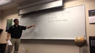
GPS RTK Surveying Workshop
Переглядів 234 тис.9 років тому
The workshop is taught by Dr. Medeiros at University of Central Florida. IAHR student chapter at UCF


IAHR Seminar Fall 2014 - Presented by Mike Salisbury from Atkins Global
Переглядів 1479 років тому
Helpful Tips for Building a Successful Career in Hydraulic Engineering and Research: Hydraulic engineering is an exciting career field that offers many unique and challenging opportunities. Whether your particular career path is in consulting, research, or academia, the hydraulic engineering/research field offers opportunities that can be rewarding, both on a personal and a professional level. ...

ArcGIS 5
Переглядів 419 років тому
The ArcGIS workshop - session 5 - Oct 2nd 2014 The screen is too bright then you need the materials (powepoint slides and exercises) given in the class.
ArcGIS 4
Переглядів 549 років тому
The ArcGIS workshop - session 4 - Oct 2nd 2014 The screen is too bright then you need the materials (powepoint slides and exercises) given in the class.
ArcGIS 3
Переглядів 639 років тому
The ArcGIS workshop - session 3 - Oct 2nd 2014 The screen is too bright then you need the materials (powepoint slides and exercises) given to you in the class to understand the explanation
ArcGIS 2
Переглядів 889 років тому
The ArcGIS workshop - session 2 - Oct 2nd 2014 The screen is too bright then you need the materials (powepoint slides and exercises) given in the class.
ArcGIS1
Переглядів 5799 років тому
The ArcGIS workshop - session 1 - Oct 2nd 2014 The screen is too bright then you need the materials (powepoint slides and exercises) given to you in the class to understand the explanation
Coastal Erosion Seminar by Dr. Plant from USGS - IAHR student chapter at UCF - April 2014
Переглядів 24010 років тому
The talk is about : "The 'Sea-level Rise Hazards and Decision Support' project assesses the potential impacts of sea-level rise and provides tools for coastal management decision making. Historical and recent observations of coastal change are combined with model simulations of coastal environments such as barrier islands, wetlands, and coastal aquifers. A Bayesian network integrates the inform...
Excellent presentation
This topic of land surveys is important for one to learn from this lecture.
Thank you Dr. Great information and well put together.
This video needs some corrections. At 1:30 he says "...maintained by the United States Air Force". The GPS constellation is both maintained and operated by the United States Air Force. Kinda Nit-picking? Well lets go on... At 1:45 he mentions "27 GPS satellites" (space vehicles); there are actually more than that in orbit, and the constellation performance requirements are based on a constellation of 24 available space vehicles, not 27. At 1:57 he says ..."wherever you're standing each satellite will pass over your head twice in a day", and at 2:30 he draws a depiction of GPS orbits and mentions "orbital planes". One of the planes he draws is a polar orbit. Be advised that the inclination for ALL of the GPS space vehicle orbits is the same, and it is 55 degrees. Importantly: between 55 deg north latitude and the north pole and 55 deg south latitude and the south pole NO GPS space vehicles ever pass overhead. Thus precision of GPS solutions for users in those latitudes degrades as they get closer to each respective pole. All you have to do is Google "GPS orbit inclination" to confirm that. Given 3+ strikes in less than 3 minutes, and you can Google to get more reliable information: I'm not wasting any more time watching this.
I love the lecture, so much detailed and i am really pleasured to have the chance to watch it.
This is fantastic
this topic on land surveying is phenomenal by the lecturer who indeed understand land surveying and what it takes be one. i wish to have him as friend so things will be in other in surveying. but want him to tell me is it possible to plotts coordinate on Google earth pro. please keep me posted on lands surveying.
Where else can I find videos like these?
I've been in surveying my whole career of about 20 years now and I've never felt like I've understood this stuff until right now, what an amazing display of intelligence and great explanation.
Great lecture
YOU BEEN I BIG BLESSING TO ME. YOU HAVE A TALENT TO EXPLAIN AND TEACH SOMETHING SO HARD I A WAY THAT I UNDERSTAND IT. GOD BLESS YOU AND YOUR FAMILY AND CAREER.
Hi. Can you do a video for static method?
Yes, this is a good general overview of GPS fundamentals but the explanation of how RTK works is wrong. At around 48:00, he mentions that the base station transmits a "delta" so the rover can correct its coordinates. Actually, the base station transmits its raw carrier phase observations to the rover so it can process the relative vector from the base by double differencing.
The base position is not a known position at all. It's.just a constant position that can be used to process a relative position from the base to the rover.. 47:07.
Awesome video. The guy teaching was excellent. Thank you to whoever posted this. 👊🏻
ua-cam.com/video/8VxJ3vuivWs/v-deo.html - ARMAR TU GPS GNSS RTK + ECONOMICO / HOW TO ASSEMBLE YOUR GPS GNSS RTK DOUBLE FREQUENCY + ECONOMY
This lecture goes veeeery sloowly and is very primitive.
Only could watch for 2 minutes. Extremely poor audio.
Excellent intro to GNSS, thank you so much for sharing
THIS IS ENOUGH ....
i like how the students asked him questions to clarify how a gps reciever would know when the signal started in order to find the difference between the time when it was sent and the time it was recieved and he just kept pointing at his dumbass explanation on the board that displayed literally zero math and expected everyone to just nod their heads as if it was a sufficient explanation....
Superb!
Thanks, Watching from Bangladesh. It's very helpfull for us
Someone probably already made this comment, but cell phones do not get additional position data from a “WiFi” signal, they get that information from a cellular signal. They try to refine your position by determining your distance from the cellular tower you are connected to.
Hey bro.im a land surveying student from Uaganda.How can we work together please
THANK YOU
At 33:57 he states that (10123, 459344) shows 10,123 meters north and not east. Is this not (East, North) just like an (x,y)? He states the Northing first, and the Easting second.
Fantastic presentation. Simple but quite informative
the best talk I have heard about gnss, congratulations, from mexico
nice well done
A nice piece ,how can i have this software.GPSRTK cost .
24 flat earthers disliked this video
Very good perspiration, Thank you
I'd expect better from a university.
The sound is faint
Well delivered information. However, is it common in USA, answer the phone middle of session?55:04 Even it’s not silent mod lol
Very well delivered talk on surveying. Very concise and to the point.
I hope sir that you could explain to us the static mode in GPS and how to observe points with static methods. Much appreciated.
I have learned a lot from this lesson, thank you very much sir
Very good presentation!
thank you very much, that was extremely helpful. hope to find another land surveying workshop videos very soon on this channel
Thanks for the presentation. Very well explained & demonstrated.
Thank you very much for publishing this information. I am using Pix4D in conjunction with aerial photos taken with my drone to produce orthomosaics. I understand the process, but in the three courses I have taken, very little explanation is provided on how to obtain the GPS data.
Nice and helpful lecture.
No stupid volume, hello :(
Very good lecture, and great overview of the GPS fundamentals.
Amazing crash course on GPS Surveying. What's with people and thinking they can just pick up their phone call in the middle of lecture? 55:05. Learn how to respect, lady.
Extremely best lesson. boosts my knowledge as a surveyor in Kenya
Hey bro how can we connect? I'm a Surveyor from Uaganda
This is a terrible explanation of how gps works.
I am interested the workshop
I was just listening and not looking at my screen and said to myself he sounds like S Medeiros. I used to work with you. Very informative video.