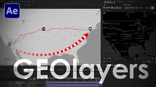
Up Your ARROW Game in GEOlayers 3 (After Effects Tutorial 2023)

Вставка
- Опубліковано 13 лип 2024
- Create and animate arrows quickly in Adobe After Effects with the GEOlayers 3 Arrow tool.
GEOlayers 3 MasterClass - bit.ly/3NK6WyY
Project File over on Patreon! - / boonelovesvideo
Monday Maps - bit.ly/3rwh55S
Tuesday Tools - bit.ly/305DkUy
0:00 Intro
0:07 Draw Arrow Tool
1:01 Retiming
1:32 Repositioning
3:03 Make the Arrow a Map Feature
3:47 Animate Along Arrow Path
4:35 Animate the Zoom, Pitch and Bearing
5:49 Add a Shadow
6:49 Get the 3D Look
7:06 The Final Animation
Tools I Used in this Tutorial -
Envato Elements - bit.ly/3o2DOYN
GEOlayers 3 - bit.ly/3zMj1Lq
Adobe After Effects - adobe.ly/41wug8J
#aftereffects #mondaymaps #maps
SUBSCRIBE! - bit.ly/3CIadYI
👤 Facebook - / boonelovesvideo
🐦 Twitter - / boonelovesvideo
🤳 Instagram - / boonelovesvideo


Did this tutorial point you in the right direction? Gaaaahhhhh
GEOlayers 3 MasterClass - bit.ly/3NK6WyY
Project File over on Patreon! - www.patreon.com/boonelovesvideo
0:00 Intro
0:07 Draw Arrow Tool
1:01 Retiming
1:32 Repositioning
3:03 Make the Arrow a Map Feature
3:47 Animate Along Arrow Path
4:35 Animate the Zoom, Pitch and Bearing
5:49 Add a Shadow
6:49 Get the 3D Look
7:06 The Final Animation
can i get free coupon code for your course ???
Dude! you are just awesome 😍
So fly... The "Duplicate plus shadow only" strategy is such a fast cool way to make things 3D in Geolayers 3...
Yeah Damian, I love the shadow technique!
Thanks a lot
Excellent video for and Excellent tool. Thank you so much !
You are welcome!
Thank you master for another lesson. I was expecting that you will upload *GEOlayers 3 MasterClass* as a gift to your fans. Anyhow, thank you.
You're welcome!
Cool man
Thanks for another timely lesson. I've been working through the masterclass as needed when I need to learn something (hopefully there isn't a time limit, LOL). You are awesome and I appreciate your work. Thanks.
Thanks! And no rush. You have access for life. :)
Thanks Boone!
You're welcome!
Thanks man, you're the best!
You're welcome! Thanks for leaving a nice comment.
thank you!!!! I was literally in GEOlayers looking up this, then got this notification, lol!
Haha, perfect!
Thankyou sir ❤
You're welcome. Thanks for watching.
thanks my friend🥰
No problem 😊
As you know, I love this arrow feature 😅
i wanna show some specific borders of a country. can i do that using Geo layers?
Hello Boone, love your channel! I can't find the draw arrow tool, it does not show by the pen tool in the geolayers tab. Any help?
hey how do you draw european plain in geo layers and how can we highlight mountain ranges
Hi, how to copy the arrow path to any other shape?
1:05 What button did you pressed to make the map 3d?
❤❤
:)
Hey Boone! Love the channel as always. I create "connected features" to indicate a route driven by a car. When I "animate feature path", I get a layer with a trim-path effect. Cool. The thing is: a geolayers arrow with an arrow head would look way better than a simple line growing. Is there any way to "apply" the geolayers arrow (with all its sweet customisability) to a "connected feature"?
Actually yes! Grab the shape layer and then in the GEOlayers panel click on Run Script File > Shapes to Arrows. That should work, but let me know.
Run Script File is at the top, just to the left of the Label Templates.
Hey Boone, search up Oversimplified, and he does videos on history and geography (ex ww2, ww1) can you do a tutorial on how he does the war map animation? (If you read this)
Which software to use sir
Why is it that when I click draw arrow, the composition automatically jumps to another mapcomp (which isn't the containing mapcomp) and forces me to draw the arrow there? Once it's drawn it doesn't show up at all in the containing mapcomp... how frustrating.
Boone, thank you for the video! I tried the Arrow shadow thing but it didn't work because most of my work in Geolayers requires me to pin the features to the mapcomp. Do you know a workaround for that?
So you created the arrow different from the above method? What happens when you get to the shadow step?
@@BooneLovesVideo I typically use KMLs to highlight roads and animate the feature path and add dashes and gaps. They automatically get pinned to the map comp which causes most of these features like drop shadows not to work. I also can’t lift them from the Z axis.
Can i get the arrow as a green screen
Hi there!
I am loving your videos, I have a request, Plz make a video about Geolayers 3 System Requirement.
I have very decent PC Specs, but after 20-30 layers it hang in after effect, My Ram usage goes to 29GB. I didn't find any solution yet. if you make a video on Recommended Specs or How to optimize Geolayers 3 much Appreciated.
MY System Specs.
i5-13600k
32GB Ram
1660 Super 6 GB GPU
Win 11 pro
Note: I Check Temps as well, Everything is fine.
Hey!! make a video on geolayers app. They created a new website. where we will be able make these videos without using after effects.
There is no Geolayers App. What are you talking about?🤷
@@michalis5817 It is new a website by the same company. Currently in beta mode.
It's in the works my friend!
bro i m going to strt a documentary channel plz gie some edting tips
to use still images
What is the name of the program you are using?
GEOlayers 3 with Adobe After Effects. Here's an affiliate link, because daddy's gotta eat - bit.ly/3Clko5I
Hey Boone, i need help about the provinces and states, when i double click on a state or province, just only appears the clicked country and the lines of the states/provinces, without marking the state that i chose. how to solve this problem? Is that a bug, natural earth or something? thank you in advance.
You can download those map features separately. Click on the little plus icon and select download features. You can then select to download States and Provences, and even the all of the countries if you want.
@@BooneLovesVideo I tried do that, but instead to appears the polygons of the provinces and states in downloads, it only appears the admin boundaries of the states and the polygons of the countries, and i dont have idea how the states polygons of Natural Earth has disappears, both in search bar and downloads. The Natural Earth Data doesnt show the states/provinces polygons, only the OpenStreetMaps polygons appears in the search, but i wanna the land coast of the states, thing that the OpenStreet doesnt do, only if i do the subtract stuff. I also tried to go in settings but nothing change.
If you use the download features method for the States and Provences data set, you can see that they are from Natural Earth. They will be place in your feature browser at the bottom, and you can draw them out directly from there. @@ElRafosk
@@BooneLovesVideo It works! Sorry for taking so long to responding you, anyway, thank you so much Boone! :)
Oh heeellllll yeah dude. @@ElRafosk
Hi sir
I need some help
How can download json data set
Of districts of indian states
Because if i do it manually
It takes lots of time
Click on the little plus icon in the GEOlayers 3 panel and select download features. You can then select to download States and Provences data set.
@@BooneLovesVideo Thank you sir
I want geolayer3 . can you proved me
i gave up, UA-cam😢 algorithm wins
What do you mean?
after a year of hard work
not this channel, was another channel i have
after a year of hard work but none of my videos got viral , havnt got even 3k views in the time that other channels with poorer graphics and topics and get thousands of views which made me to give up and stop making more videos,
yes YT algorithm wins @@BooneLovesVideo