Hi! I am an amateur user and I just now start to learn the softwares. Is there any way I can download data similar to 3D so I can use them as an elevation drawing? If that makes sense .. thanks a lot in advance!
Hi Laju, if you use the zoom extents command it should centre the view on the map. You can also right click the layer, select objects and then use the zoom selected command to zoom in on the objects this way - hope that helps
Hi Any tips on how to import the site onto the Grid at (0,0) ? My import is really far away from the origin. I used the move tool to bring it to origin but it would have been better if it worked like yours
Hi H P, digimaps data will always be aligned to a global coordinate system so is usually really far from the origin when you import. The best thing is to do as you did and just move the map by using the move tool and typing in 0,0,0 to move the model to the origin
Hi Cal, a DWG is an autocad file type which is likley why it is only giving that option. If you open Rhino and choose File, Import then you should be able to open it this way


Hi, this topography is flat? how do i make it accurate?
thanks for sharing!
No problem!
thanks tom
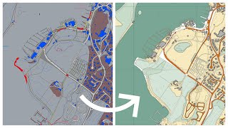
hi i try to do download for large area but the map is downloaded in divided by tile i can't able to download single file for my site
This is good.
Regarding the co planar faces
Can you do this in auto cad then in to Revit
Please could you explain how to use the terrain data as well as my site is not flat! I am really struggling to create the site terrain.
Hi! I am an amateur user and I just now start to learn the softwares. Is there any way I can download data similar to 3D so I can use them as an elevation drawing? If that makes sense .. thanks a lot in advance!
mine imported and shows the layers on rhino but i cant see the actual map anywhere. I cant move it to the center because I dont even know where it is
Hi Laju, if you use the zoom extents command it should centre the view on the map. You can also right click the layer, select objects and then use the zoom selected command to zoom in on the objects this way - hope that helps
thank youuuuuuuuuuuuuuuuu
Hi Any tips on how to import the site onto the Grid at (0,0) ? My import is really far away from the origin. I used the move tool to bring it to origin but it would have been better if it worked like yours
Hi H P, digimaps data will always be aligned to a global coordinate system so is usually really far from the origin when you import. The best thing is to do as you did and just move the map by using the move tool and typing in 0,0,0 to move the model to the origin
Hey! My university is not registered with digimaps. So is there any other alternative?
Cad mapper its free !
it doesnt give me an option to open with rhino, only autocad, any idea why?
Hi Cal, a DWG is an autocad file type which is likley why it is only giving that option. If you open Rhino and choose File, Import then you should be able to open it this way
when i try to import it, it claims it was successfully imported but it doesn't show
@@calmcgarrity489 It's probably out of your viewport. Type in ZOOM, EX and hit enter, you'll be able to see the model. :)