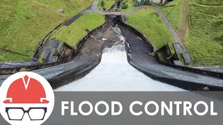
Sacramento River Flood Control System

Вставка
- Опубліковано 28 сер 2024
- The U.S. Army Corps of Engineers, State of California and local agencies manage one of the world’s largest, most complex flood risk management systems. Learn how it helps prevent flooding in California, particularly the Sacramento region, and what upgrades are still needed.


I've hunted in and studied these structures for years and didn't understand the big picture this well until watching this video. Very informative, good job. Didn't even know the Butte basin was a thing. I suppose a lot of the hunting refuges in this area wouldn't exist without the bypass system preventing residential development. The Sacramento, Delavin, Colusa, and Sutter refuges are all examples of this. There are also wildlife areas like Yolo bypass wildlife area and feather river wildlife area which is between the river and a setback levee.
Flood plains replenish the underground water reservoir. The local government put pavement and housing over flood plains which are never meant to be inhabited by people and California is having a drought because of this mismanagement.
And they're just dumping it all into the ocean though the delta
So Bakersfield is not a desert. They just ruined the whole land🫤
@@youtubeprimer9669 Thats where its supposed to go, theres too much being taken and shipped elsewhere and the habitat and ecosystem is suffering for it
@@JD21055 ok you stop using water first
GREAT VIDEO ITS THE ONE I'VE BEEN LOOKING FOR i LIVE IN OREGON AND REALLY DON'T UNDERSTAND THE WATER SYSTEM. I'M VERY CONCERNED ABOUT YOUR LOWER VALLEY BECAUSE OF ALL THE FLOODING AND THE REALLY BAD WEATHER CALIFORNIA IS ABOUT TO GET iLL BE PRAYING AND GODBLESS HOPE YOUR LEVEE'S AND DAMS HOLD UP
We could be in trouble this spring and summer. I wouldn't want the job of maintaining snow runoff this year. Wishing the best for those in control of the snow runoff.
What most people dont know abouit California is that we get record snow fall on the west slope of the sierra. Especially at the central sierra directly east of the a Sacramento /San Joaquin river delta which drains into San francisco bay. This bay/delta is like an open door to any low pressure systems. its not uncommon to get 600 inches of snow in a season. I've seen it dump 10 feet of snow in a single storm! It all happens in the higher elevations of the Sierra,only 50 to 60 miles east of the central valley where we may be seeing temps in the 60's! The Midwest has cold weather and snow but rarely does the Midwest get more than 200 inches of snow in a season! Try to tell someone from the Midwest that California gets more snow than Iowa! They will call you a liar!
Why does all that Fresh water get wasted Redirected into the sea :(
California is several decades overdue for a mega-flood. It's not a matter of if, only a matter of when. With property damage approaching a trillion Dollars, the resulting "cataclysm" will be unprecedented in US history. Northern California's system of levies will almost certainly fail, transforming the entire Central (Sacramento) Valley into a "great inland sea" nearly 40 miles wide and several hundred miles long. It will begin suddenly, with very little warning. Here's the most likely scenario; During any given rainy season, beginning in October/November, cold, powerful winter storms develop over the gulf of Alaska and track south, southeast along the coast, one after another, moving inland and dumping up to 100' of snow in the high Sierra. January comes along and the storm track shifts southerly. A relentless (tropical) atmospheric river or "Pineapple Express" dumps the equivalent volume of 40-50 Mississippi rivers on California by February, melting most of the (lower elevation) mountain snowpack in the process. The resulting deluge is Biblical in scope. The city of Sacramento, along with all of it's suburbs, become inundated with at least 10' of flood water. With each passing year the odds of a mega flood increases and global warming is accelerating the time-frame.
This system will definitely be tested in the coming days/weeks...
was it? what was the update?
@@georgeguy2963 the levies held
What a fascinating Runoff will occur this year. The warnings were ignored. MWM
This is a good learning tool, but you need to get rid of the distracting music. It's unbearable.
Truly saddened by the erosion control measures taken on the east side of the American River near H street bridge and Campus Commons. Many trees were lost. To this viewer my thought was that the banks on the east side were clay based (not the levee, the banks) and not under threat of erosion leading to eminent danger.
Thank you for the video
Great maps!
Ancient rivers of gold claimed the whole west was rivers at one time
Why does all that fresh water get wasted and redirected into the sea :(
On its journey from the mountains to the sea, fresh water is actually stored at dozens of locations. It’s an extremely complex balancing act, though, because water needs to be stored for purposes like irrigation, drinking water and recreation, but also released to provide water for hydropower, fish and wildlife habitat conservation downstream, and released during high water events to reduce flood risk. To add to the challenge, California has the most variable weather conditions in the nation, often fluctuating between extreme drought and extreme flood.
Specifics about water storage and supply is more of a question for the California Department of Water Resources (CADWR) since they manage a lot of those projects, whereas the Corps of Engineers primary role in water management is reducing flood risk through infrastructure improvements and setting guidelines for flood control releases at dams.
CADWR has a lot of info on their website that might help explain more about how fresh water is stored: water.ca.gov/What-We-Do/Water-Storage-And-Supply
They also have a contact form here: water.ca.gov/Contact
You should start reading books -it will prevent you from asking such naive questions
Because Newsom
The flood basins are great and counter act the well intended idea of channeling water to the ocean rather than replenish our largest reservoir, the underground aquifer. Channeling the water to the ocean in a state with 40 million people is just plain stupid in 2023. We need to have a plan to flood the hundreds of thousands of dormant fields all the way to Bakersfield during the rainy season. We already have the Mendota and California aqueducts south of Suisan Bay that could easily release more water to the adjacent lands to replenish the ground water.
Do you build for 100 year events or 1000 year events?
We typically build for 200-year events. California requires urban areas build for a minimum 200-year level of flood protection. www.cityofwestsacramento.org/government/departments/city-manager-s-office/flood-protection
An example of a 200-year project is our Sacramento levee improvements project being constructed now:
Project Brochure www.spk.usace.army.mil/Portals/12/documents/civil_works/CommonFeatures/WRDA16/Documents/ARCF_Trifold_220315.pdf
Project Video ua-cam.com/video/jBrtzsjVCVM/v-deo.html
Mankind how is this working out for you?
I'm chillin.
Not bad. You?
if a volcano erupted in san fran bay an plugged outlet the valley would fill up
This is probably one of the most brainless comments i have ever seen.
And the state canceled the federal goverments plan to prevent the flooding that could bring a second noahs flood. Crazyy
We are in God's hands prayers for humanity amen
See!!! They're just waiting water into the ocean!!! Were in no drought california is just damned.
This funding occurred in Egypt during the time of Moses California is becoming Egypt ten commandments