How the Flood Risk Management System Works (Animation)

Вставка
- Опубліковано 1 вер 2021
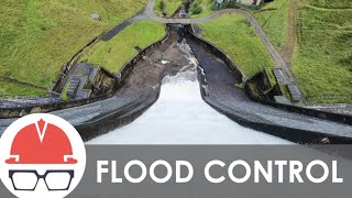
- Did you know? Despite its complexity, the flood risk management system in Northern California consists of only a few major components - primarily dams, levees, weirs, and bypasses. See how they work together to move water away from people and property in this animation.
- Наука та технологія


Thanks for the video a lot, it really helps me to have a picture on what database tables I should create for the demo.
Im gonna do a monitoring tool for a College project based on this animation for a flood detection system, if things work well I will share it here!
hi, which software that make this animation?
Hi Ven Fx, we used Blender www.blender.org/ to create the animations. We also have various engineering 3D models on our webpage here www.spk.usace.army.mil/Media/3D-Resources/ you can download for free and use in your own animation products.
City should be planned away from water banks and can be used as parks or ecological areas, conservation zones and instead of managing the floods.
HS
Hello @sacramentodistrict Can I Share your videos in my Channel?