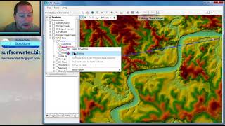
Terrain Modification in HEC-RAS Part 1: Bathymetry

Вставка
- Опубліковано 18 вер 2024
- In this video, we add bathymetry to a river channel using a 1D geometry created in RAS Mapper. In Part 2 we'll cover removing no-data areas, and in Part 3 we'll cover the addition of dams, levees, buildings, detention basins, etc. Part 4 covers the replacement of no data values.
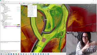
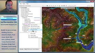
Note: the methods shown in these video are outdated for all applications except adding bathymetry. Use the new terrain modification tools in HEC-RAS Version 6 for buildings, dams, levees, etc. Updated instructions for linear features are shown here: • What's new in HEC-RAS ... and instructions for polygon features are shown here: • What's new in HEC-RAS ... .
If you are interested in customized support for detailed terrain modification or other tasks, please contact me at www.surfacewate... to request a demo.
More videos are available at www.surfacewate.... Come join us for an open course, or we can tailor an in-house course to use your actual projects as tutorial examples.
If you need help with your own project, we can customise a solution for you; please send an inquiry using www.surfacewate....


I'm watching all your videos now! Always learning something new! Thanks a lot from italY!
this man is a literal GOD
Sir you are amazing. You explained well and pls make more videos.
Hello Krey,
Thanks for your helpful videos.
Would you mind going over 1d-2d coupling particularly ‘connections’; also if you don’t mind using applicable time step in relation to cell sizes, distance between XS & channel depth. If you also talk about calibration.
Thanks again.
Very useful. Thank you
Excellent. Thanks. Also, I wonder how to update a DEM with sonar surveys (points)
Thanks for the video! I want to do this for a reservoir, do I use the same method, or is there a different method specific to reservoirs bathymery?
The method would be the same. If you wanted to breach the dam that forms the reservoir, however, you'd need to be sure to remove it from the terrain and build it back again as a weir.
Perfect, super helpful!
Thank you for the video. I have got a quetion though: how can I update the bathmetty if I have point measurement data? The thing is I have hunderds of cross sections for which I have point measurements and therefore it would be extremely time consuming to modify the cross sections manually. Is there a faster way to do this in HEC-RAS?
Not sure your data format, but is it easier that you create a new Dem file using your data point and cut xs from your new Dem?
Hi Kian, you can do it automatically using a python code to edit the geometry file (.g##) that contains cross sections data. If you want to understand more how to do that, open your geometry file using notepad and take a look at the info that you'll see.
Great Video. I have a quick question:
Generally I've used 1-D modeling for stream restoration projects. This typically involves setting up an existing geometry file with cross sections based on detailed survey data. I would then use the channel design editor and template tool to create proposed cross sections in a proposed geometry file. I would then go ahead and run the 1-D model under existing and proposed conditions and compare the results (focusing on water elevation, shear stresses, velocities, etc).
So, it sounds like moving forward, after I create my proposed cross sections I should follow the steps you outlined in this video to create a new merged "proposed" terrain that can be used for both 1-D and 2-D modeling?
The channel modification tool is still more powerful than the method I've shown, since you can get more automation such as daylight lines, cut/fill volumes, constant bed slope, etc. out of it. Watch for lots of cool new terrain editing tools coming in Version 5.1.
how do i add bathymetri to storage area??
Can you do a video explaining the channel modification tool? I'm having a hard time understanding why it won't do what I want it to do.
How to modify terrain with braided rivers and multiple reaches to the mainstream
Thank you very much! Is It possible to get the file you worked in?
👍
Hello, I am Peruvian and I would like to know if the courses are in Spanish or if they have a translation.
Thanks
What is the previous video to this that you speak of?
can i request the data you use?