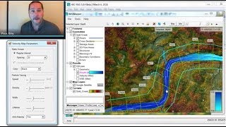
3:38 launch Hec-Ras 5:01 PDF manual 8:32 retrieving terrain data 14:30 projections, reference systems 20:40 Hec-Ras project architecture 21:18 starting a project 23:50 open Ras Mapper; set projection for my project 25:30 Create a new "RAS Terrain" (“New Terrain Layer”) Grab a raster from your disk 27:57 Filename: create the .hdf version of your raster and name it properly 29:33 What has Hec Ras done with you raster files? Do you need all of the files in the Terrain folder? 31:30 vector elevation data 31:58 .asc (ESRI Grid) files: internal structure and nodata value. From Wikipedia: "xllcorner and yllcorner are the western (left) x-coordinate and southern (bottom) y-coordinates, such as easting and northing (represented as real numbers with an optional decimal point), when the data points are cell-centered xllcenter and yllcenter are used to indicate such registration." 33:04 Put a coarse-resolution DEM underneath your high-resolution DEMs, in order to avoid missing a data or nodata areas. 33:55 avoid decimals beyond millimetre. 1/128 precision is fine. 34:30 Irregular grids 38:12 checking if your raster is good for your job 39:40 plotting a cross section 40:50 add web imagery (Google Hybrid) 41:55 Save View for storing WMS imagery even when disconnected from Internet 42:10 add and save views from the project 44:30 add profile lines (3 ways to do it). Add center line(draw FROM UPSTREAM TO DOWNSTREAM) and put it in shapefiles 45:43 Add cross sections (draw FROM LEFT TO RIGHT LOOKING DOWNSTREAM) 48:20 Properties of the DEM layer (colours, UPDATE PER SCREEN etc.) 49:02 Don’t forget to fill in the Description field in the main Hec Ras menu
thanks krey! i actually took your class in AWS recently, its nice to see you posted a cascade of help videos even several years ago that i am just watching now. cheers!
With some basic knowledge about ArcGIS, shape file, Tiff and Rasta Imagine , your speech speed are very good. A lot of information and presentation was well done. Thanks for teaching us. Keep up...
I have watched this video about 20 times and each and every time I learnt something. one more thing, to get DEM files you can download it from earthexplorer.usgs.gov
Thanks - added the link to the description. A walk-through of the process of extracting EarthExplorer terrain data for use in RAS Mapper using is available in our HEC-RAS 6.0 series here: ua-cam.com/video/5VtUVpHyY0I/v-deo.html
Hi! I´m doing my masters thesis on Two-stage ditches and looking at erosion to evaluate the effectiveness of these ditches in Sweden. I have not used Hecras before so I´m wondering if this software handles smaller watercourses and if its possible to adjust the settings according to soil types in this software?
Hello Krey! First of all thank you for your YT videos, I have been learning a lot from them. I do have a question tough. In the header of this video, it does seem that you modelled a culvert through an existing roadway embankment. How did you do that? Every time that I need to model a culvert through an existing embankment, I need to modify the terrain using RAS-MAPER and then, model the embankment as it was a bridge. Thank you sooooo much :)
Hello thanks for all the valuable information in this course. I have a problem. my options tool in Ras Mapper doesn't have all the options. I don't have "set projection for Project". what's the reason?
excelente tutorial ingeniero de verdad muchas gracias les saluda desde peru. una sugerencia para descargar la topografia del area de estudio por la plataforma elvis no accede o u otra manera de descargar la topografia mas precisa por favor. gracias y saludos
just wanted to ask do we have to import subbasins which were generated in hechms, in hecras and then do we need to define boundary condition for each subbasin separately or do we have to create a single 2d flow area perimeter for all the subbasins as whole, for 2D flood modeling? as we'll be using outputs from hechms which were generated for each subbasin
Thanks so much, very informative. I'm in the UK and can't seem to find a website with free DEM with 20 cm in 20 cm pixel size to use in HEC-RAS. Is there any and could you please tell me how to get them. Thanks
لقد أرسلت 25 مايو الساعة 2:13 م Hello, how are you? I want to download the hec ras program (6.0,5.0.7,5.0.6,5.0.5,5.0.4) where I encountered an OPNE RAS problem that did not work for me please I want a solution
Hello, I am new to HEC RAS and I am encountering a Run-time error '9' Subscript out of range when importing a geometry file from AutoCAD civil 3D to HEC RAS. Any idea why this is happening?
if i am using HEC-RAS in US-Feet, does the projection need to be in US-Feet? i downloaded the project for UTM 15N but it is obviously in meters. Should i just leave the cross section river stations in feet? Thanks! The file i am uploading is a combined DEM + survey surface that i have exported from Civil 3D to a DEM as well. That was all done in the UTM 15N projection but in US-Feet...
hello sir we are trying to run a flood simulation for our state , Kerala, INDIA, as have shown in this video, while pressing create after uploading the tif file of terrain its showing a error message, what to do, waiting for your reply.
Good afternoon. Dear, my name is Bruno. I'm a civil engineering student in Brazil. I need to carry out a simulation of the rupture of an earth reservoir for water storage located outside the water course. My question is whether Hec Ras allows me to carry out this type of simulation or if Hec Ras is just a simulation of structures in the water course. Is there any software that allows me to simulate the rupture of an earth reservoir to accumulate water outside the water course?
Hi, for the terrain and projection data. I'm struggling to get these data. I've been told to use National River Flow Archive and OS Terrain 50 for the UK but honestly can't find the data in these websites. Do you have any suggestions please?
Hi Craig. Can you possibly give me a hand with a VERY interesting project in Western Africa? It could help an awful lot of people, but I need to be sure of the ancient waterways. No offence, but I just can't seem to wrap my head around HEC-RAS. It's like German documentation to me.
Hallo. I had a finally problem with my ras project. I would be greatful if you could help me. I want to display the depth of 2d flow to a real map. I set the projection to ras mapper but when I click map layers> add web imagery layer>google hybrid, seems to be a problem and when a place the mouse over the file there is this message : "Error loading image from file C:/Users/..../tif does not exist in the file system and is not recognized as a supported dataset name'' Thankyou.
Hello. I have sent countless requests for Bisbane's terrain data with different mail accounts but no one has sent me a mail for the data download. What do I do? Thanks.
Hi all. Very useful video. Only one problem. I can not load any wms layer. Even for the examples. I am using the correct projection though. Any help? Regards , Petros
Hey, I am a student from a higher technology college for civil engineering. I am working on my diploma thises right now and I am struggling with HEC-RAS. Noone of my professors has ever used it before or at least not on such a high level. Is it possible to import a terrain file (XYZ file) that includes "." as commas and "," as separation? And if not, do you have an idea how I can change this into the Metric System?
You'll need a raster grid digital elevation model. Point clouds won't work, even if the points are sampled on a regular grid. You could do a find and replace in the text file to change the separators if necessary, but you'll also need to do a conversion to a raster grid using other software (AutoCAD/Civil3D, ArcGIS, etc. have conversion features that take point files and convert to raster grid DEM). Appendix B of the HEC-RAS 2D user manual lists the supported file formats.
Draw a profile line across the flow path, then right-click on it and select "Cumulative Volume" under time series, which essentially computes the area under the hydrograph. The results can be shown graphically or select the "Table" tab to copy and paste the numbers into Excel. If the simulation window has run long enough for the cumulative volume curve to flatten to a constant value, the final value will be your total flood volume/flux across that particular profile line. If this is computed at the inflow and outflow locations, the difference in volumes should equal the system storage.
If RAS Mapper does not open, typically it is an issue with a 32-bit operating system (since RAS Mapper is 64-bit). It won't work on a 32-bit operating system, and sometimes still has issues with a 64-bit system if it's out of date. Best to install all Windows updates (windowsupdate.microsoft.com) including .net framework, and reinstall HEC-RAS if necessary.
Thank you for the great effort. I can send you a batch to make multiple folders at once instead creating them one by one. If you are interested, reply with your email.


Damn This Guy is legit!! Thumbs up to you Good Sir👍
3:38 launch Hec-Ras
5:01 PDF manual
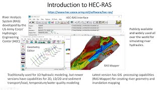
8:32 retrieving terrain data
14:30 projections, reference systems
20:40 Hec-Ras project architecture
21:18 starting a project
23:50 open Ras Mapper; set projection for my project
25:30 Create a new "RAS Terrain" (“New Terrain Layer”)
Grab a raster from your disk
27:57 Filename: create the .hdf version of your raster and name it properly
29:33 What has Hec Ras done with you raster files?
Do you need all of the files in the Terrain folder?
31:30 vector elevation data
31:58 .asc (ESRI Grid) files: internal structure and nodata value.
From Wikipedia: "xllcorner and yllcorner are the western (left) x-coordinate and southern (bottom) y-coordinates, such as easting and northing (represented as real numbers with an optional decimal point),
when the data points are cell-centered xllcenter and yllcenter are used to indicate such registration."
33:04 Put a coarse-resolution DEM underneath your high-resolution DEMs, in order to avoid missing a data or nodata areas.
33:55 avoid decimals beyond millimetre. 1/128 precision is fine.
34:30 Irregular grids
38:12 checking if your raster is good for your job
39:40 plotting a cross section
40:50 add web imagery (Google Hybrid)
41:55 Save View for storing WMS imagery even when disconnected from Internet
42:10 add and save views from the project
44:30 add profile lines (3 ways to do it).
Add center line(draw FROM UPSTREAM TO DOWNSTREAM) and put it in shapefiles
45:43 Add cross sections (draw FROM LEFT TO RIGHT LOOKING DOWNSTREAM)
48:20 Properties of the DEM layer (colours, UPDATE PER SCREEN etc.)
49:02 Don’t forget to fill in the Description field in the main Hec Ras menu
Thanks for that - I've added these bookmarks to the video to break it into chapters.
Thank you very much, you are the best
I didn't want the tutorial to end. Thank you.
One of the most informative video about HEC-RAS for beginners.
Bro can i install hec ras software in 2 GB system
It is my first contact with HEC-RAS and this video is very helpfull. Will chech out your other HEC-RAS educational videos. Thank you a lot.
Thank you! Appreciate the (quick) pace and level of detail, very useful
I like the way you teach how to start doing modelling rather than jumping straight into the model set up.
You got 1+ subscriber from India.... Thank you for putting so much efforts
It was like watching your favorite movie!!!!
So informative video.
Thank you very much!!!!!!!!!
Incredible lecture. Really appreciate that you published this
thanks krey! i actually took your class in AWS recently, its nice to see you posted a cascade of help videos even several years ago that i am just watching now.
cheers!
Thank you so much for you elaborative presentation. It is little fast but it is not a issue.
With some basic knowledge about ArcGIS, shape file, Tiff and Rasta Imagine , your speech speed are very good. A lot of information and presentation was well done. Thanks for teaching us. Keep up...
You're awesome. Thank you very much!!! +.+
thank you. meaningful and very easy
you are a great prof
hello, thank you for this video. I have been re-watching it to run it
Thanks a lot! Very informative video, with a lot of useful sidetracks. Your speed is appreciated.
hello sir, it was really helpful. thankyou for making such informative vedios for the young enginners. thanks a lot
Thank you very much for the helpful tutorials!
Great job Krey.
Very Informative. Thank you. Newbie here
Very clear and well structured. Many thanks
Thank you very much for this helpful and informative video!
Clear and very useful, thanks ! (i just set the speed at 90 % cause i'm not a native speaker^^)
Thank you so much
Very nice video!
Thanks for the video!
This was a really informative video, thank you for the content.
Very informative and helpful, thanks
Hey Kery. Thanks for the fantastic videos. Can you share the videos of HEC-RAS? HEC-HM and HEC-RAS integration for real time flooding?
I have watched this video about 20 times and each and every time I learnt something. one more thing, to get DEM files you can download it from earthexplorer.usgs.gov
Thanks - added the link to the description. A walk-through of the process of extracting EarthExplorer terrain data for use in RAS Mapper using is available in our HEC-RAS 6.0 series here: ua-cam.com/video/5VtUVpHyY0I/v-deo.html
Could you explain how to create dem file as tiff format from google earth to hecras?
Awesome!
Hi! I´m doing my masters thesis on Two-stage ditches and looking at erosion to evaluate the effectiveness of these ditches in Sweden. I have not used Hecras before so I´m wondering if this software handles smaller watercourses and if its possible to adjust the settings according to soil types in this software?
How is it now
Genio¡¡ gracias
Hello Krey! First of all thank you for your YT videos, I have been learning a lot from them. I do have a question tough. In the header of this video, it does seem that you modelled a culvert through an existing roadway embankment. How did you do that? Every time that I need to model a culvert through an existing embankment, I need to modify the terrain using RAS-MAPER and then, model the embankment as it was a bridge. Thank you sooooo much :)
Hello thanks for all the valuable information in this course. I have a problem. my options tool in Ras Mapper doesn't have all the options. I don't have "set projection for Project". what's the reason?
Can you please make a video on adding lateral structure and analyzing the result?
ty
excelente tutorial ingeniero de verdad muchas gracias les saluda desde peru.
una sugerencia para descargar la topografia del area de estudio por la plataforma elvis no accede o u otra manera de descargar la topografia mas precisa por favor. gracias y saludos
wow great job thank you. i have ras mapper not open. is is or windows. im looking for solution thank you
just wanted to ask do we have to import subbasins which were generated in hechms, in hecras and then do we need to define boundary condition for each subbasin separately or do we have to create a single 2d flow area perimeter for all the subbasins as whole, for 2D flood modeling? as we'll be using outputs from hechms which were generated for each subbasin
Thank you Sir.It is Excellent. But
.I'm waiting for two months and not able to open the hec usace web link.
Excuse me, I would like to know how to open ras model because I click the ras model to open the ras model window, but it wasn't open up.
I wonder if there's a tutorial to install HEC-RAS linux version, I have not found anything about it :(
How are we meant to find the area without any coordinates
Hi, I’m currently in South Africa now I’m struggling to get the proper projections can you assist
What to do if the downloaded projection file's unit is in meter but I have to use feet since I am located in United States?
Thanks so much, very informative. I'm in the UK and can't seem to find a website with free DEM with 20 cm in 20 cm pixel size to use in HEC-RAS. Is there any and could you please tell me how to get them. Thanks
لقد أرسلت 25 مايو الساعة 2:13 م
Hello, how are you? I want to download the hec ras program (6.0,5.0.7,5.0.6,5.0.5,5.0.4) where I encountered an OPNE RAS problem that did not work for me please
I want a solution
RAS can be downloaded here: www.hec.usace.army.mil/software/hec-ras/download.aspx
Hello, I am new to HEC RAS and I am encountering a Run-time error '9' Subscript out of range when importing a geometry file from AutoCAD civil 3D to HEC RAS. Any idea why this is happening?
if i am using HEC-RAS in US-Feet, does the projection need to be in US-Feet? i downloaded the project for UTM 15N but it is obviously in meters. Should i just leave the cross section river stations in feet?
Thanks!
The file i am uploading is a combined DEM + survey surface that i have exported from Civil 3D to a DEM as well. That was all done in the UTM 15N projection but in US-Feet...
hello sir we are trying to run a flood simulation for our state , Kerala, INDIA, as have shown in this video, while pressing create after uploading the tif file of terrain its showing a error message, what to do, waiting for your reply.
Good afternoon.
Dear, my name is Bruno. I'm a civil engineering student in Brazil.
I need to carry out a simulation of the rupture of an earth reservoir for water storage located outside the water course.
My question is whether Hec Ras allows me to carry out this type of simulation or if Hec Ras is just a simulation of structures in the water course.
Is there any software that allows me to simulate the rupture of an earth reservoir to accumulate water outside the water course?
ua-cam.com/video/V34YsWgrEXY/v-deo.html
Hi, for the terrain and projection data. I'm struggling to get these data. I've been told to use National River Flow Archive and OS Terrain 50 for the UK but honestly can't find the data in these websites. Do you have any suggestions please?
Hi Craig. Can you possibly give me a hand with a VERY interesting project in Western Africa? It could help an awful lot of people, but I need to be sure of the ancient waterways. No offence, but I just can't seem to wrap my head around HEC-RAS. It's like German documentation to me.
Hallo. I had a finally problem with my ras project. I would be greatful if you could help me.
I want to display the depth of 2d flow to a real map. I set the projection to ras mapper but when I click map layers> add web imagery layer>google hybrid, seems to be a problem and when a place the mouse over the file there is this message : "Error loading image from file C:/Users/..../tif does not exist in the file system and is not recognized as a supported dataset name''
Thankyou.
Dear Professor hello, do you know how can I download terrain data of Turkey?
Hello. I have sent countless requests for Bisbane's terrain data with different mail accounts but no one has sent me a mail for the data download. What do I do? Thanks.
Hi all. Very useful video. Only one problem. I can not load any wms layer. Even for the examples. I am using the correct projection though. Any help? Regards , Petros
Did you ever figure it out?
Unable to find 'select area' tool on ELVIS 11:23
Ras mapper doesn't want open in my computer any solution please
my rasmapper geometry editor wont work on windows 7 64 bit can someone kindly solve my problem
When will continue video upload.?
Hey, I am a student from a higher technology college for civil engineering. I am working on my diploma thises right now and I am struggling with HEC-RAS. Noone of my professors has ever used it before or at least not on such a high level.
Is it possible to import a terrain file (XYZ file) that includes "." as commas and "," as separation? And if not, do you have an idea how I can change this into the Metric System?
You'll need a raster grid digital elevation model. Point clouds won't work, even if the points are sampled on a regular grid. You could do a find and replace in the text file to change the separators if necessary, but you'll also need to do a conversion to a raster grid using other software (AutoCAD/Civil3D, ArcGIS, etc. have conversion features that take point files and convert to raster grid DEM). Appendix B of the HEC-RAS 2D user manual lists the supported file formats.
Hi, is it possible to have the files you used?
hello. where i can download projection file zone 38T? because I cant found this zone on spatial reference
Select UTM zone
How we calculate the flood volume in ras mapper ?
Draw a profile line across the flow path, then right-click on it and select "Cumulative Volume" under time series, which essentially computes the area under the hydrograph. The results can be shown graphically or select the "Table" tab to copy and paste the numbers into Excel. If the simulation window has run long enough for the cumulative volume curve to flatten to a constant value, the final value will be your total flood volume/flux across that particular profile line. If this is computed at the inflow and outflow locations, the difference in volumes should equal the system storage.
hello
i instal the hec ras 5.0.4 and 5.0.7 , but, the (ras mapper) do not work, please you can help me and thank you
If RAS Mapper does not open, typically it is an issue with a 32-bit operating system (since RAS Mapper is 64-bit). It won't work on a 32-bit operating system, and sometimes still has issues with a 64-bit system if it's out of date. Best to install all Windows updates (windowsupdate.microsoft.com) including .net framework, and reinstall HEC-RAS if necessary.
@@TheRASSolution How do i get intouch for online training or otherwise
Tinggal dmno om ?
Hello, I cannot open the web: hec.usace.army.mil..... Can you help me??? Thank you
go through VPN
31:18
I am sorry it is not clear for beginners
Elaborate
Thank you for the great effort. I can send you a batch to make multiple folders at once instead creating them one by one. If you are interested, reply with your email.