I took a permanent sharpie and crossed out all of the "weird" scales on the plotter. I won't need the WAC and the cognitive overhead is too high for the others as well.
As you all may have figured by now, it doesn't matter because you can use EITHER a latitude line OR a longitude line. The inner scale numbers are just a minor convenience. Just make sure whatever course you come up with passes the sniff test (just by eyeballing it you can tell if it should be between 0-90, 90-180, 180-270, or 270-360). If the course you come up with was 041 and it was supposed to be between 0-90, then you likely got the correct course).
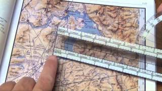
If you have a course that is generally north-south and your plotter doesn't have an inner scale, you may be able to simply draw an extended line until it crosses a line of longitude.
Slow down a bit and give and show more details...that would have to be some close'up camera work...you are very likable just don't rush the lesson so that most new student pilots get it the first time...hope that helps?


This was exactly what I was looking for with no BS. Thanks!
Glad it helped! 😀
😂😂😂😂😂 exactly
These have been confusing for so long to me and this was a great explanation!
thank you so much, liz! had no idea how to get the right course with this thing but this has made it very clear!
Glad it was helpful! If you found it helpful consider subscribing for more content like this one! 😊
Great presentation. Covers everything. No more, no less.
Great job! No issues following along as a new pilot.
Excellent information Liz. I sure hope that's an erasable marker, unless you have several copies of the chart...lol.
Don't worry we have a magical eraser... Just kidding. It was an extra chart she brought! Thanks for watching! 😀
Very well done!
Very clear. Thanks
So, how do you remove the line you drew on the sectional chart? They look to be expensive maps.
You don’t, they are usually only 10 bucks and last a few months
If you want to keep these maps clean, you can put a plastic coating around it and use a dry-erase marker to draw instead.
I really love the plot of this video
Sad trombone sound
THANK YOU SO VERY MUCH! I THOUGHT FOR A SECOND I HAD A DEFECTIVE PLOTTER
I took a permanent sharpie and crossed out all of the "weird" scales on the plotter. I won't need the WAC and the cognitive overhead is too high for the others as well.
Great explanation! Thank you
Thank you! That was exactly what I was looking for!
I can’t figure out how you’re saying “longitude.”
Brilliant! a welcome review, with thanks from an old pilot.
Thanks this was a great concise easy to understand explanation and demonstration
Does the protractor part need to be at 0 at the top middle?
Why does it sound like she’s on the verge of tears?
great video, but what can i do if my plotter doesnt have the inner scale numbers, i have a CP-R PLOTTER, hope your answer thx.
mine also doesn't have one, same question
also wondering!
Buy another one for $7.49.
As you all may have figured by now, it doesn't matter because you can use EITHER a latitude line OR a longitude line. The inner scale numbers are just a minor convenience. Just make sure whatever course you come up with passes the sniff test (just by eyeballing it you can tell if it should be between 0-90, 90-180, 180-270, or 270-360). If the course you come up with was 041 and it was supposed to be between 0-90, then you likely got the correct course).
If you have a course that is generally north-south and your plotter doesn't have an inner scale, you may be able to simply draw an extended line until it crosses a line of longitude.
Lots of help thanks
Thank you for your help!
What if I want to draw a straight line between two airports and my scale is not long enough? Any idea?
Great job, as usual!
Thank you! Cheers!
Normally I would just use that thing to draw planes...now I'll be using it to fly them.
This proves earth is concave
217 Sabrina Rapids
and u think is that easy as u lecture
Slow down a bit and give and show more details...that would have to be some close'up camera work...you are very likable just don't rush the lesson so that most new student pilots get it the first time...hope that helps?
It’s a video….pause it, restart it.
You are definitely one of those people aren’t you.
You’re the one who’s slow. Stfu
Bro just wants to see more of her 🤢
If this was too fast with not enough detail I have some bad news for you.
Watch it twice and if you don’t understand it, don’t be an aviator