2 year ago when i saw this video i don't understand any thing. But now i have clear concept and i am working on it. So now i understand very well with video speed 0.75😉
how do we deal with quantity that have been already paid on clearing and grubbing item in Ha. because this fill section volume does not consider the 15cm cleared surface below the Original ground surface . but practical filling material also includes the 15cm that has been removed by clearing activity.
I have done already making a Quantity Takeoff Criteria and proceeding to compute materials EG and Datum did not appear in object name. How can I solve this one? @Jeff Bartels
Hi Mr. Bartels and thank you, for your great support. My question is the following: Can C3d be forced to place a ditch on the side slope of an embankment? I need to give continuity to this ditch until reach the discharging point. I tried using the BasicSideSlopeCutDitch command to do it, but i can't. Do you have any advice? Than you! Benjamin
Hi your cut fill volume have a error in calculation 4+25 to 4+50 Their is 25 in 2d distance But compare to road profile and slope It's go more than 25 feet Civil 3D have this problem And iam trying more time but How to solve this problem Till i not know Please answer if you have any idea
You’re really the best AutoCad instructor and I appreciate you to much. However, I’ll be much happier if you can go slowly in your step to steps approach. You speaks to fast and sometimes it’s difficult to follow. Thanks
Jeff i have been watching alot of videos and i cant seem to find an answer and i am hoping you might have an idea. when calculating the cut and fills, how do you account for removal of surface along the daylighting and replacement with top soil? your yellow datum comes up along the pavement and to the tie in point on the existing surface. if say this was rocky along the edge and 5' was replace with top soil, i would want to calculate as part of the cut. any ideas how to include that? thanks
Jeff! you are one of the best in the area of civil engineering! I have a question though! Assume I have surveyed the natural sub-grade of a road project before excavation commences and taken survey data. Subsequently, after excavation, I have taken survey data at the same station after excavation work is concluded. Now, having two data with different elevation points, how can I calculate the earthwork volume using Civil-3D? Thanks in advance!
I come from a construction background and the way you so you videos are straight to the point and so easy to understand! Currently, I am working in the 4D planning space and one of the biggest items we discuss about is interfaces with existing infrastructure for provision of Traffic management. Would you be able to create a video about the best ways of mapping and modelling existing roads. I have thought about using Infraworks however it is open source and needs refinement. Now i am looking at leverage GIS data in terms of OS mapping and lidar surfaces. But it seems rather manual. Any thoughts would be helpful :) By the way i am not a design engineer but i am very fascinated by the tools!
I really like the tutorial! but i'm also experimenting with it and won't work (completely). To make a long story short; I made a assembly of a road section with stripping pavement. So I make the quantity takeoff criteria, so far so good (here I can select the surfaces which I created. Than I go to compute materials, I select my criteria which I made and there I can't select the surfaces? it won't show them. What am I doing wrong? (btw it's is kind of strange to select the surfaces again because you already did in de quantity takeoff criteria) Can someone please help?
Jeff Bartels , Thanks for your help. However, I would like to generate a single grid with multi. sections which major grid hori. & vert in model space rather than layout.


Once again Jeff saves the day! thanks for the help!
You're welcome!
2 year ago when i saw this video i don't understand any thing. But now i have clear concept and i am working on it. So now i understand very well
with video speed 0.75😉
Thank You Mr Jeff
Thank you so much for this video, helped alot!!
Glad it helped!
how did you create the datum surface?
Under Corridor Surfaces just create one but then click the green plus sign to specify the DATUM code underneath
Jeff
I'm your big fan.
I give you like before watching your videos.
Your videos are amazing!!!
Thanks
Great video, thanks man
GREAT INFO - THANK YOU !!
thank you so much. And where can i find my report from my computer ?
What Tipe Asembly have you used for daylight , I See you have and extra space after the edge of pavement, what do you do ?
hi jeff. I am just learning Civil 3D. Im wondering how did you make the datum surface. Your response is greatly appreciated.
how do we deal with quantity that have been already paid on clearing and grubbing item in Ha. because this fill section volume does not consider the 15cm cleared surface below the Original ground surface . but practical filling material also includes the 15cm that has been removed by clearing activity.
I have done already making a Quantity Takeoff Criteria and proceeding to compute materials EG and Datum did not appear in object name. How can I solve this one? @Jeff Bartels
Hi Mr. Bartels and thank you, for your great support. My question is the following: Can C3d be forced to place a ditch on the side slope of an embankment? I need to give continuity to this ditch until reach the discharging point. I tried using the BasicSideSlopeCutDitch command to do it, but i can't. Do you have any advice?
Than you!
Benjamin
You are really amazing my friend. Thank you so much!!!
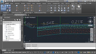
Hi your cut fill volume have a error in calculation
4+25 to 4+50
Their is 25 in 2d distance
But compare to road profile and slope
It's go more than 25 feet
Civil 3D have this problem
And iam trying more time but
How to solve this problem
Till i not know
Please answer if you have any idea
You’re really the best AutoCad instructor and I appreciate you to much. However, I’ll be much happier if you can go slowly in your step to steps approach. You speaks to fast and sometimes it’s difficult to follow. Thanks
Very good work
Thank you so much 😀
Great job sir, be blessed
Thanks, you too!
Any chance you can show me how to create the styles you selected in the drop-down menu for the CUT & FILL. Thanks!
Hi Asa, watch this video, I show how the styles are set up at about 2:40. ua-cam.com/video/mz6q_vHysbE/v-deo.html Hope this helps!
@@JeffBartelsCAD Thank you so much!
I am watching your videos on Lynda. Great job.I wish you could show cut fill calculations for commercial projects
The is great information 👍 👌 thanks
Jeff
i have been watching alot of videos and i cant seem to find an answer and i am hoping you might have an idea. when calculating the cut and fills, how do you account for removal of surface along the daylighting and replacement with top soil? your yellow datum comes up along the pavement and to the tie in point on the existing surface. if say this was rocky along the edge and 5' was replace with top soil, i would want to calculate as part of the cut. any ideas how to include that?
thanks
Jeff! you are one of the best in the area of civil engineering!
I have a question though!
Assume I have surveyed the natural sub-grade of a road project before excavation commences and taken survey data. Subsequently, after excavation, I have taken survey data at the same station after excavation work is concluded. Now, having two data with different elevation points, how can I calculate the earthwork volume using Civil-3D?
Thanks in advance!
thanks a lot keep going you're the best
I come from a construction background and the way you so you videos are straight to the point and so easy to understand! Currently, I am working in the 4D planning space and one of the biggest items we discuss about is interfaces with existing infrastructure for provision of Traffic management. Would you be able to create a video about the best ways of mapping and modelling existing roads. I have thought about using Infraworks however it is open source and needs refinement. Now i am looking at leverage GIS data in terms of OS mapping and lidar surfaces. But it seems rather manual. Any thoughts would be helpful :) By the way i am not a design engineer but i am very fascinated by the tools!
Great.
What version of civil 3d is this? 2015 or ?
How do you do to have the end result for you earthwork? Not only section by section, but the total to have a final cost of it?!
I really like the tutorial! but i'm also experimenting with it and won't work (completely). To make a long story short; I made a assembly of a road section with stripping pavement. So I make the quantity takeoff criteria, so far so good (here I can select the surfaces which I created. Than I go to compute materials, I select my criteria which I made and there I can't select the surfaces? it won't show them. What am I doing wrong? (btw it's is kind of strange to select the surfaces again because you already did in de quantity takeoff criteria) Can someone please help?
thank you very much sir
Most welcome
Thanks a lot. If possible, could you tell me how to generate single grid with multiple sections in model space like youtube video?
I think this might be what you are looking for - ua-cam.com/video/fPGA3SLgQN8/v-deo.html
Jeff Bartels , Thanks for your help. However, I would like to generate a single grid with multi. sections which major grid hori. & vert in model space rather than layout.
Hi! Please can you show me how I can makestripping both in fill and in cut of existing ground ?
Thanks
awesome excellent video, much easier than using LSS
My volume report is coming out to be blank. What to do?
how to put existing ground into proposed grading plan and how to calculate cut and fill if there is materials.need video to watch and learn.thanks
Reply
sir i am a civil draftsman want to know how to make grading on road will you please help to record a special video on road grading
best explanation
Very nice
Thank you!
How to add the strippe topsoil?
Thanks sir
You're welcome!
Hi if is it possible please make a video about how to converts points in civil 3d
helpful video
Glad to hear that!
Thank you!!
You are welcome!
Sir you belong to which country
sir can you share the file so we can follow. if not it's okay i understand. thanks
pls where is the privies video
parabéns !!
dear brother any one have xy.left please share me i lost
add more video