Thank you for the tutorial meanwhile,I noticed there was a mix up in the 2nd and 3rd column it should be latitude,longitude as latitude value is always more than the longitude value.
@@obasiezekieluchechukwu3726 You need to have the boundary of your study area separately. You can watch our video on how to download administrative boundary shapefile of any country


Thank you for the tutorial meanwhile,I noticed there was a mix up in the 2nd and 3rd column it should be latitude,longitude as latitude value is always more than the longitude value.
Do you have the link for arcmap download?
why mine is not working? when i add data, it does not show Longitude and Latitude in X and Y field
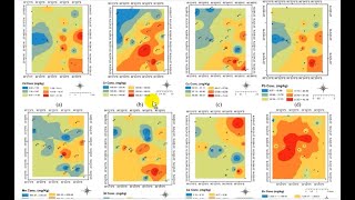
Thanks, how can we explain or discuss the colour of each iron concentration, what does red means,green ,yellow
Nice Tutorial
Will IDW give same result as Kringing method ?
No, but you can try the two to see the difference
How did your own boundary just come about? Do I have to just create mine cos I just can't find it as illustrated in your video.
@@obasiezekieluchechukwu3726 You need to have the boundary of your study area separately. You can watch our video on how to download administrative boundary shapefile of any country
@@obasiezekieluchechukwu3726 Here's the link to the video: ua-cam.com/video/_6EI7SwbbPk/v-deo.htmlsi=WjsYSEWldEKRmB5H
Thank you brother.
I've seen the video, it's great.
Can I still get a shape file of a school located in a particular region?
thanks is interesting👏👏 , where can i download the datasets used in this tutorial
The dataset used is the results of lab analysis of water samples
Your leature is good
Thank you