@12:21 - I work as a surveyor in Southeast Texas using the R8 base unit with R10 rover and the TSC3 Controller. We have never had problems importing points with alpha-numeric characters in the point name field and numeric characters in the code field. We usually call our base point: BASE and put 80D for the code (since we use 80D's for our control points). Maybe its because we don't use AutoCAD to import the points; we use Simplicity Sight Survey with IntelliCAD. Just thought I'd mention that :) great video by the way. Always interesting to see how land surveying is done in other states/regions.
Very helpful can you also teach establishing uknown base with 2 known points and another 1 for elevation point. Id like to see the data controller process ❤.
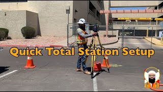
I am not sure about other surveyors because I work alone and teach everybody how to use the R10. My tripod is not a fixed height tripod. I am not sure what you are referring to when you say, fixed height tripod. I thought all tripods had adjustable lengths.
@@farmingandranchingnewmexic2972 image.tigersupplies.com/Products/LargeImages/SECO5119-10.jpg The fixed height allows you to negate the effects of your measure ups (measuring the height to the bottom of the quick release for R10s or bottom of mount for R8s) and now the only human source of error is the centering error. The bubbles on the above referenced tripod are 8 minute bubbles (if I recall correctly) and as long as you regularly check the bubble and keep it dialed in, then the most centering error you'll see is +/- 0.016 ft; enter that in your A Priori settings in TBC, run your network adjustment and you're good to go. ;-)
Good job, very clear. As I work always with R8, I am wonder where the Radio here? is it included with the Base or because you work in small area so you it does not affect? Thanks
Do you have more info on that notch your measuring too on the quick release for the R10. I’ve had some vertical error with my R10 and have seen different constant offset numbers for the quick release
You have to tell the base how high it is above the ground when you are setting up the project in the data collector. This is why I measured the distance between the ground and lever arm on the base.
BTW, I forgot to ask: Do y'all use state plane for every job you do or do you sometimes use a local grid system? We only use state plane when we are doing elevation work or if the client is wanting to know accurate latitude and longitude of property corners.
Not necessary. He can make one based on that set up. He will need to correct it afterwards with GNSS post processing software, or just shoot one with the rover if one is close by with known coordinates. Also he can make on and shoot it during the topographical survey he's executing then - post process, then when he returns to the field he can set up his base over his new CP and all will be well henceforth.


Yellow wedding ring?
This dude REALLY LOVES Trimble!
@12:21 - I work as a surveyor in Southeast Texas using the R8 base unit with R10 rover and the TSC3 Controller. We have never had problems importing points with alpha-numeric characters in the point name field and numeric characters in the code field. We usually call our base point: BASE and put 80D for the code (since we use 80D's for our control points). Maybe its because we don't use AutoCAD to import the points; we use Simplicity Sight Survey with IntelliCAD. Just thought I'd mention that :) great video by the way. Always interesting to see how land surveying is done in other states/regions.
You can always use a plumb bob or the tribach optical plummet to ACTUALLY find the reference point.
Very helpful can you also teach establishing uknown base with 2 known points and another 1 for elevation point. Id like to see the data controller process ❤.
Thanks for making the video, however why do I continually see people not using fixed height tripods???
I am not sure about other surveyors because I work alone and teach everybody how to use the R10. My tripod is not a fixed height tripod. I am not sure what you are referring to when you say, fixed height tripod. I thought all tripods had adjustable lengths.
@@farmingandranchingnewmexic2972 image.tigersupplies.com/Products/LargeImages/SECO5119-10.jpg
The fixed height allows you to negate the effects of your measure ups (measuring the height to the bottom of the quick release for R10s or bottom of mount for R8s) and now the only human source of error is the centering error. The bubbles on the above referenced tripod are 8 minute bubbles (if I recall correctly) and as long as you regularly check the bubble and keep it dialed in, then the most centering error you'll see is +/- 0.016 ft; enter that in your A Priori settings in TBC, run your network adjustment and you're good to go. ;-)
Good Job bro
If you use external batteries it’s necessary to put the internal battery ?
Would you happen to have any slides of this?
WHAT IS THE TOLERANCE OR ACCURACY OF THIS INSTRUMENT
Great video, im also a surveyor
Thanks bud! Very helpful video!
Good job, very clear. As I work always with R8, I am wonder where the Radio here? is it included with the Base or because you work in small area so you it does not affect?
Thanks
Do you have more info on that notch your measuring too on the quick release for the R10. I’ve had some vertical error with my R10 and have seen different constant offset numbers for the quick release
I have the bag on the tripod.. not sure what to sell it for
just a quick dummy question, did this base and rover can be used for Drone Survey? Thank you
I am not sure if this Rover and base can be used for a drone survey but I can find out.
Why would you put out a video where the sound cuts out in part of it?
haha i think the camera was picking up the exact frames on the screen
thank u sir ...very helpfull video
thank you. It helps
If you didn't set up over a pin, why did u measure to the ground?
You have to tell the base how high it is above the ground when you are setting up the project in the data collector. This is why I measured the distance between the ground and lever arm on the base.
Thanks for your kind information
Thanks you
Thanks 👍
Is it jammed? Do you take away such a stone from the ground?
There is no jam. The rock only shows me where to measure from the ground.
@@farmingandranchingnewmexic2972 hii, am interested on RTK GPS
BTW, I forgot to ask: Do y'all use state plane for every job you do or do you sometimes use a local grid system? We only use state plane when we are doing elevation work or if the client is wanting to know accurate latitude and longitude of property corners.
जामाड आहेबक खाली दगड टाकून ग्राउंड लेवल घेतोय
I can’t find the hole!😂
👍🏻👍🏻👍🏻
Great video would be much better if camera guy keeps his hand off the microphone. Missed some valuable content.
That’s the wind
Great audio lol
you cannot always hear the mike.
Sir do u hire staff from aboard
As a trainee
Dear vedio not...see......
Vibrating......
Don’t even set your base up on a CP??
Not necessary. He can make one based on that set up. He will need to correct it afterwards with GNSS post processing software, or just shoot one with the rover if one is close by with known coordinates. Also he can make on and shoot it during the topographical survey he's executing then - post process, then when he returns to the field he can set up his base over his new CP and all will be well henceforth.
Friends, maybe you have an unnecessary, outdated, broken geodetic equipment, which I have given a new life to.
Amateurs!!!