LAKE SHASTA: WHERE ARE THE FISH!!?? (areas/spots shown)

Вставка
- Опубліковано 15 жов 2024
- I just posted the latest video of my 40th place finish at the first Wild West Bass Trail Pro/Am event on Lake Shasta. Click the link here to watch: • WILD WEST BASS TRAIL P...
Today I am recapping that tournament and showing you what I found during the event that could be a huge benefit to anyone fishing in the next month at the lake.
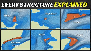
Google Earth Pro is a huge tool for all fishermen, and what a big factor in my finish and what I found. During this video, I will go over what makes Google Earth Pro even more special right now and can help net you a few extra fish.
Please like and SUBSCRIBE to the channel if you found this info useful!
Edwin Evers videos on uploading Google Earth waypoints:
Part 1: • Finding fish on GOOGLE...
Part 2: • GOOGLE EARTH PART 2! /...
Neko Rig setup:
Rod - Dobyn's Fury 7' ML - www.tackleware...
Reel - Lew's Mach 1 - www.tackleware...
Main line - P-Line 10lb Hi-Vis Yellow X-Braid - www.tackleware...
Leader line - P-Line 7lb prototype fluorocarbon leader
Weight - prototype screw weight 1/16oz.
Hook - #1 Owner Mosquito - www.tackleware...
5” Yamamoto Senko (green pumpkin/black flake) - www.tackleware...


This is amazing
WOOOOOW!
I really liked that information on google maps I’m fun fishing up their this up coming weekend . How many ft. down was the lake in the www tournament weekend . Thank you for sharing google info . I will need to transfer that to a helix unit hopefully I can figure that out.
My Humminbird is old, but I can still do everthing you're doing on google earth on my 999 including satellite view, water level offset & Lake Master chip for western states
Do you have anything on fishing Shasta in the fall by chance?
Hey man love the channel. I fish Folsom every week and I use Google Earth Pro and do the same thing with the history but I don't mark my spots like you do. Mainly because I didn't know I could transfer the spots I mark on there to my graph. Super helpful. Well hopefully I can I'll have to watch Edwin's videos to find out...Gonna try the "free" weight set up next week and hopefully a ton of new spots that I mark on Google Earth. Thanks for the info.
Bro...I've been on Google Earth since I posted this 4 hours ago. My wife is not happy. haha.
awesome video 🤙 Going out tomorrow gonna check out bank fishing
Is this google earth website or app? I can't find wather deapth info from browser.
Great video, Thomas. Thanks for sharing your knowledge.
Great video man. Super helpful. Keep up the good work 👍🎣
Hey...so I've been on Google Earth a ton since watching this video and was wondering if you noticed when you mark a WP on the map if you change the historic dates your WP's are now off? If you mark a rock on 1 date and you go to another date your WP's are not on that rock any longer? I'm marking ditches and creeks etc and change the dates and they sometimes differ like a hundred feet away from where I marked the creek on another date.
Yes because depending on the date, the water levels differ greatly in some cases. If you look at lakes in 2014 you'll see the water is way lower then it is in 2019 or other years
@@TheBassHookup Right...but a marker you make on Google Earth has GPS Coordinates and those GPS Coordinates should not change based on water level. Example: I can mark a rock when a lake is at 50% capacity then view the lake on a different date at a lower capacity, lets say 30% and my way point is not on that rock like I marked at 50%. That rock didn't move because the water level dropped. Only the water moves, not the rock or the GPS coordinate. I'm not talking about little baby rocks someone could move, I'm talking boulders here. I was marking spots on Oroville and noticed when changing dates some of my way points on different dates moved by hundreds of feet, not up or down from water levels, the WP literally moved away from a rock I marked previously. Mark several huge rocks on a lake and try it out, some of my WP's move off the spots greatly from pic to pic. Just thought I'd bring this up cause I go to the lakes lowest level on Google Earth and mark stuff that would be currently under water which may not be all that accurate, I haven't had the opportunity to mark stuff on Google Earth and go compare in a boat yet but will next week to test it out.
@@dbender3644 yep i noticed the same thing! My waypoints were off by quite a bit from where i marked them before.
@@mikelepori707 Ya they can be off especially for lake oroville. So when you're out on a lake if you're going to fish a island top or something under water that you marked on Google Earth throw some casts at it first before driving over it and if you don't feel anything or get any bites then drive over it with you graph and check it out. I marked a ton of WP's on Folsom Lake and so for they are all pretty darn accurate. Overall though I take every WP I mark with google earth with a grain of salt, if I can get in the general area I can find it with Side Imaging normally.
The lake is so low right now you should just use the image from now if there is one