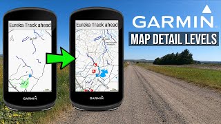
Garmin Edge 1030 Navigation

Вставка
- Опубліковано 5 лют 2025
- VeloGPS showcase the course navigation feature on the Garmin Edge 1030. Includes demo of map, data and elevation screens - enjoy !
Checkout our 'Kit' listings for great Garmin offers and essential accessories:
Garmin Edge 1030: kit.com/VeloGP...
For further GPS Cycle Computer & Tech offers visit us at: kit.com/VeloGPS
Music
3.29 - 6.51 Tobu - Nostalgia / tobuofficial


Great vid to see how the maps behave .. tnx!
Glad you found it helpful 😀
From your experience VELOGPS, what would you recommend to do MTB trails in the woods? Basically navigating trails in the woods.
Cool vibes too
Very useful video, instructional. My 1030 has got a bug: in nav mode, I type and search and address, but when I want to delete one, it actually doesn't delete it! Never! It moves that address on top!
Hello Sir, may I know how to record screen while on a ride?
Can be a dumb question, but can I use Edge 830 or 1030 to car, pedestrian and bike nav? Thanks for the video, was very educational
On mine, the data field at the bottom of the map (it's on default settings...i haven't adjusted anything since it came out of the box) seems to show elevation indication. Is that correct? And two pins.... i guess i'm the big one and a smaller pin that is jumping around all over the place!!! What is this data field supposed to be telling me?
How do you stop and take the 1030 with you into a cafe, say, without buggering up the recording of your ride? I tried to do this and lost the second half my ride though it appeared to be working.
Thought those lanes look familiar! I live in Basingstoke and the inlaws live in Odiham so round that way all the time. Can you add more than two data fields to the navigation screen? Cheers Jon
Lol - someone local recognises the roads every now and again ! 2 data fields is the max on the Nav screen.
VELOGPS - THE INNER TUBE ...and you can swipe left or right to get other data screens ? Correct ? ...cheers....
Yep. You can set up several additional data screens and swipe between all of them (and the map) during your ride.
VELOGPS - THE INNER TUBE brilliant, thank you....cheers.... Mal....Oz 🚴🏻♂️🇦🇺
buen dia, como puedo hacer que en la pantalla de altura aparezca el punto de mi ubicación porque en mi edge 1030 no aparece
Hi, I'd be interested to see a navigation and operational review of the Teasi one3 unit which seems to be floating around on the internet. It looks similiar in operation to my old Mio Cyclo 505 device, but with additional features and better sensor support.
My 1030 has some bugs, the most annoying of is the impossibility of deleting a saved position!
Can I create a route on the units screen? Tap on screen to set destination? Don’t want to use a computer.
Yep - you can place pins on a map or use destination locations including postcodes. If you want to plan and ride a specific route imo it is better to do so on a PC.
VELOGPS - THE INNER TUBE Thank you. That could work for me.
Can be elevation graph be panned? I would like to see forthcoming profile without having to always change axis-x
Good video -thanks
Do you know if the small black triangle that indicates your position on the map screen can be changed to white and enlarged as I find it difficult to see the default one with my middle aged eyes :-)
Thanks for the feedback JP - would be interested to know how do you change the icon
JP - would be interested to know how do you change the icon too
I wish Garmin would Bluetooth pair these to a Bluetooth speaker (ie: JBL flip) to give audible turn-by-turn directions.. "turn right in 200 ft" etc.. The bluetooth is there, and the Coding has already been done on the car GPSs.. So why not install the Coding for the EDGE GPS...? This would be a great safety feature, so you don't have to take your eyes off the road to look at the computer on turns.. Voice turn-by-turn would be a great feature on the EDGE..
Would be nice to hear the audio prompts rather than music.
Is it possible to zoom out on the elevation screen? During a ride it's common I want to check how much climbing is left overall but my 520 doesn't offer that.
You can zoom in/out on the elevation screen on most of the touchscreen Edge units. If you look at the elevation screen in this video (approx 3.52 onwards) you will note that there is a scale (number) detailed on both of the graph axis - this denotes the distance represented by each square on the axis. If you tap this number on the screen (touchscreen device only) it brings up a + and - on the screen which you can use to zoom the elevation graph in/out. I use this on big climbs on unknown rides where I have uploaded a course in order to pace myself.
VELOGPS - THE INNER TUBE great, thanks.
Is this course created in Basecamp ? Needs it TBT information ?
Created in Garmin Connect
And if the course is from a other source, the change from MAP screen to Data screen still works if you have make a Turn ?
I created a similar course with Garmin Connect but doesn't work that well like your video. its saying faster everything i try to use and doesn't show turn by turn. do you know what cause the issue?
Hej. Er det muligt at taste en rute direkte på computeren. Altså jeg vil til a videre til b osv.
Ja - Jeg vil sammensætte en video der viser dette snart, men hvis du tjekker Edge 1000 videoer på min kanal, er der en lignende demonstration - forhåbentlig har google translate gjort en vis følelse af dette!
can I upload Strava route into it and get instant turn by turn navigation? Because thats what everyone uses to share routes..
yes
is it possible to do one for the wahoo elemnt/ bolt?
Sure is ua-cam.com/video/eMTU3_BsJTU/v-deo.html - enjoy 😀