Best Practices for RTK & PPK Drone Flights | Webinar Recording

Вставка
- Опубліковано 5 сер 2024
- Ben Vander Jagt, Lead Developer for PhotoCapture, discusses the process of improving the quality of data captured using RTK/PPK enabled drones including Advanced Fields Settings, calibration parameters, and ground control/checkpoint philosophy.
Create an account and try Carlson PhotoCapture today with 5GB free - photocapture.carlsonsw.com/re... - Наука та технологія


Excellent!
Nice tutorials...
Great video. Just so I'm clear on definitions. When calibrating the camera you talk about nadir mission and roll camera. Could you define the term or action? Thanks...
I wanna learn it, but too hard. Thank you for yout informs!~
I might have missed it, how did they correct for the unknown base station in the case study you mentioned at 46:00? Is there a way to do it in post or did they have to refly the mission?
Can I use my GRX7 to send corrections to a Phantom 4 Pro RTK via NTRIP RTCM3?
Comprehensive explanation, I'm very thankful.
I was wondering if you could email me the presentation.
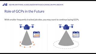
can you use rtk drone for gcps?
placing drone on a gcp as a rover , take the coordinates?
That same tin I wanna ask...thank you
That won’t give you the precision you will want for ground control points. But you need a base for phantom rtk so you can use the base but you have some learning to do
Thank you for the presentation,but as a relative begginer in the field i have problems with grasping a few things.1)What exactly is the difference between a checkpoint and a gcp?I get that they are similar but i cant find any good answer on the web.2)What is the difference between a known and an unknown point?I know that a known point is better and gives us a higher accuracy,but what i need to do to get a known point?Is it possible to explain this to me i layman terms?Thank you.
A checkpoint is a Point that you use to check the accuracy in your project "manualy" after you are done with the map or model.
A gcp is similar but you add it to the project befor you run the calculation and all the points are
corrected automatically in the calculation.
A unknown point is easier to explane. It is a point with no prior
physical representation in the real World, for instance a pipe in concrete or a metal nail in asphalt. That is all the points you measure with gnss.
A known point i measured and balanced from another known point in a grid with accurate methods and has some physical feature to set up your measureing equipment on.
🙄🙄🙄
Does the software produce useable 3D data?
Can u give a detailed course .. We would be more than happy to pay
🙄🙄🙄🙄🙄
😱😱😱😱😱😱