❄️Birg, Switzerland Drone Flight Video | World from Above

Вставка
- Опубліковано 9 лют 2024
- Birg, Switzerland Mountain Village Drone Flight Video | World from Above
Feel free to contact me for collaboration. I am a drone pilot based in Switzerland. Video material available for sale in 4K.
♡ Subscribe for more content @: ua-cam.com/users/worldfromabo...
#Birg #Switzerland #dronevideos #droneswitzerland #worldfromabove | World from Above
Music: UA-cam Audio Library: Snow Princess - Jimena Contreras
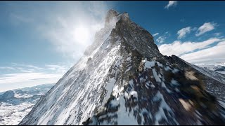
Birg (2,684 m) is a summit of the Bernese Alps, overlooking the valley of Lauterbrunnen in the canton of Bern. It lies on the east flank of the Schilthorn, above the village of Mürren.
In winter Birg is part of a ski area and several cable car stations are located on its summit. Birg is also an intermediate station between Mürren and of the Schilthorn.
Birg appears as the ski station nearest to Blofeld's alpine headquarters Piz Gloria in the James Bond film "On Her Majesty's Secret Service." It is first seen from a helicopter, but also has a scene set on it later on.
The Bernese Alps (German: Berner Alpen, French: Alpes bernoises, Italian: Alpi bernesi) are a mountain range of the Alps, located in western Switzerland. Although the name suggests that they are located in the Berner Oberland region of the canton of Bern, portions of the Bernese Alps are in the adjacent cantons of Valais, Fribourg and Vaud, the latter being usually named Fribourg Alps and Vaud Alps respectively. The highest mountain in the range, the Finsteraarhorn, is also the highest point in the canton of Bern.
The Rhône valley separates them from the Chablais Alps in the west and from the Pennine Alps in the south; the upper Rhône valley separates them from the Lepontine Alps to the southeast; the Grimsel Pass and the Aare valley separates them from the Uri Alps in the east, and from the Emmental Alps in the north; their northwestern edge is not well defined, describing a line roughly from Lake Geneva to Lake Thun. The Bernese Alps are drained by the river Aare and its tributary the Saane in the north, the Rhône in the south, and the Reuss in the east.
The Bernese Alps are amongst the three highest major subranges of the Alps, together with the Pennine Alps and the Mont Blanc massif.
One of the most prominent Alpine ranges, the Bernese Alps extend from the gorge of Saint-Maurice, through which the Rhône finds its way to Lake Geneva, to the Grimsel Pass or, depending on the definition, to the river Reuss (thus including the Uri Alps). The principal ridge, a chain that runs 100 kilometres (62 mi) from west (Dent de Morcles) to east (Sidelhorn), whose highest peak is the Finsteraarhorn, forms the watershed between the cantons of Bern and Valais. Except for the westernmost part, it is also the watershed between the Rhine (North Sea) and the Rhône (Mediterranean Sea). This chain is not centered inside the range but lies close (10 to 15 km) to the Rhône on the south. This makes a large difference between the south, where the lateral short valleys descend abruptly into the deep trench forming the valley of the Rhône and the north, where the Bernese Alps extends through a great part of the canton of Bern (Bernese Oberland), throwing out branches to the west into the adjoining cantons of Vaud and Fribourg. There the mountains progressively become lower and disappear into the hilly Swiss Plateau. The Bernese Alps have a large influence on the climate of Switzerland: while their north side is very exposed to weather, their south side is protected from it. As a consequence, agriculture consists essentially of dairy farming and cattle breeding on the northern foothills, while on the sunnier southern foothills (Rhone Valley) it also consists of vineyards.
Gemmi Pass is the most central of the major passes through the main chain. It also marks the separation between two distinct sections of the Bernese Alps: the chain west of Gemmi Pass, consisting mainly of foothills with a few large glacier-covered mountains (notably Dent de Morcles, Grand Muveran, Diablerets, Wildhorn and Wildstrubel) around 3,000 metres (9,800 ft), and the chain east of Gemmi Pass, consisting mainly of summits around 4,000 metres (13,000 ft) on several subranges, with large valley glaciers between them. The latter section, contrary to the former, has very few foothills and is the most glaciated part of the Alps.
A characteristic in the orography of the Bernese Alps is, that whereas the western portion of that chain consists of a single series of summits with comparatively short projecting buttresses, the higher group presents a series of longitudinal ridges parallel to the axis of the main chain, and separated from each other by deep valleys that form the channels of great glaciers.


Welcome to World from Above channel and enjoy this drone video recorded in Birg, Switzerland. Let me know in the comment section what do you think about it. Please like and subscribe for more drone content.