This is an awesome video Cameron, but as an engineer for the military, I can only add this to the list of things this year that made me realize how little I know. It's a good preventative for the Dunning-Kruger effect. And that's from someone who can make sense of hodographs and has been deeply interested in weather since I was 5 (34 now).
I got my undergrad on biochemistry but my passion for learning and observing storms definitely makes me wants to go back. I want to be a meteorologist. Thank you for sharing your knowledge with us!
Wow, this is a diamond in the rough. I feel privileged to be watching and absorbing this information-thank you for the knowledge! I honestly don't even have questions or other comments about the topics covered because you did so so thoroughly lol. I feel like I would enjoy some sort of viewer follow-along quizzing video for analyzing case studies and guessing the results with information given should it be productive to forecasting skill, and I think you would make a great host for that medium
Really interesting video. You can defiantly learn from looking up at a storm and you can tell what it might do.its really helpful to learn about hodographs and learning forcasted and current soundings to see how the storm will change with time and hight.
15:21, I have seen this a lot when chasing. Lightbulb moment. I will often see the occluded old cycle of a storm off to the SW, behind the rain, while the new cycle spins up. They always appear to be very skinny. I always used to think those were the dying mesocyclone, but I think those are actually the dying, occluded tornadocyclone, after the tornado has lifted.
Cameron, You did a fantastic presentation of what some might consider a complex topic. I especially like how you compared the hodograph to an actual storm. Please make more videos, some of us like expanding our knowledge.
A very interesting talk and I've learned a lot from from it. Yet there are a few points where I disagree: 1. To estimate the helicity, the hodograph must not be seen relative to the motion of the storm system, but relative to the motion of an individual cell or updraft center. In the case of a propagating squalline, its motion relative to the hodogrpah might suggest very large SRH, while what it is actually doing may be rapidly producing shortlived individual cells, which individually move with the winds of the free atmosphere. As a result, each individual cell acquires much less vorticity from the boundary layer than you suggest, and it does so only for a short amount of time, as one updraft center is soon replaced by another. 2. Why should the shear within the inflow level be relevant for hail? What really matters for large hail is that the hail growth zone stays in place relative to the inflow, so the hail can stay in place. This should be the case when (i) the wind in the -10 to -30°C level closely matches the motion of the updraft and (ii) the shear in the -10 to -30°C level is not too large. There might well be a lot of shear below that level. 3. how can a relatively weak updraft support heavy hail? A very strong updraft will throw small hail out of the hail growth zone. A weak updraft will not be able to keep hail in the growth zone for long. I think what we need for large hail is one of the following two options: a) A lateral gradient in updraft strength, so that hail stones fall into layers of progressively stronger and stronger updraft, as they grow larger. A certain amount of shear in the hail growth zone seems to be necessary for that process and here I can also imagine that low level vorticity disturbs this stratification. So low level shear might inhibit the formation of large hail for a different reason. b) A very strong updraft combined with the right shear profile: Hail stones ascend in the strong updraft, until they enter a layer of intense shear above the hail growth zone , where they get evacuated out of the updraft in direction, but as they soon fall out of this layer, they get reinfused into the updraft under the hail growth zone soon. This process would also require the right coordination of updraft motion and the hail stone trajectory, but in contrast to a), significant high-mid level shear, maybe combined with some veer-back in the appropriate height would be needed. Would be interesting to hear your thoughts on this.
Thanks so much Cameron, every installment you have put together of this talk over recent years has introduced more key concepts. This is the best yet, a phenomenal resource alongside your webpage, thank you so much again from the UK!
Amazing informative video! It is amazing too see how the storms change with height! Very helpful for me to learn how to read hodographs and increase my forecasting and my meteorological knowledge.
Would be cool to know first is how is this Hodograph data is collected? Ballons or radar???? And what the circular map represents...ground area or elevation cross section?
The ones shown in the video are from weather balloons, but it is possible to get this from Doppler radar using Velocity Azimuth Display (VAD) Wind Profiles aka VWP.
Great presentation, Cameron! I like the mention of the SE US tornadic hodographs frequently having less than 90 degree critical angle. We’ve noticed the same thing. One question we have is, what impact do forested areas have on the surface wind measurements and the critical angle?
Just outside Lubbock, TX 6/24/19! Fun fact, this was actually a left-mover that I mirrored because I liked it so much for this, and wanted folks to not have to think too hard!
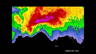
Did the cyclic and long-track tornado-producers reflectivity maps get swapped when you switched from the still to the moving examples? Or am I losing my mind? (2:45 ish) Regardless, thank you for this talk!!
I finally got something right. I picked the top storm because the meso looked more developed. Either that or just lucky like a blind hog looking for an acorn


This has got to be one of the most useful storm chasing video ever! this is genuinely incredible!!!
This is an awesome video Cameron, but as an engineer for the military, I can only add this to the list of things this year that made me realize how little I know.
It's a good preventative for the Dunning-Kruger effect.
And that's from someone who can make sense of hodographs and has been deeply interested in weather since I was 5 (34 now).
Thank you for this information, really well-done man. I absorbed it like a sponge.
I got my undergrad on biochemistry but my passion for learning and observing storms definitely makes me wants to go back. I want to be a meteorologist. Thank you for sharing your knowledge with us!
Wow, this is a diamond in the rough. I feel privileged to be watching and absorbing this information-thank you for the knowledge! I honestly don't even have questions or other comments about the topics covered because you did so so thoroughly lol. I feel like I would enjoy some sort of viewer follow-along quizzing video for analyzing case studies and guessing the results with information given should it be productive to forecasting skill, and I think you would make a great host for that medium
And now look at you Andy!!!
Go kandy
Really interesting video. You can defiantly learn from looking up at a storm and you can tell what it might do.its really helpful to learn about hodographs and learning forcasted and current soundings to see how the storm will change with time and hight.
I agree Jon!
15:21, I have seen this a lot when chasing. Lightbulb moment. I will often see the occluded old cycle of a storm off to the SW, behind the rain, while the new cycle spins up. They always appear to be very skinny. I always used to think those were the dying mesocyclone, but I think those are actually the dying, occluded tornadocyclone, after the tornado has lifted.
Cameron, You did a fantastic presentation of what some might consider a complex topic. I especially like how you compared the hodograph to an actual storm. Please make more videos, some of us like expanding our knowledge.
A very interesting talk and I've learned a lot from from it. Yet there are a few points where I disagree:
1. To estimate the helicity, the hodograph must not be seen relative to the motion of the storm system, but relative to the motion of an individual cell or updraft center. In the case of a propagating squalline, its motion relative to the hodogrpah might suggest very large SRH, while what it is actually doing may be rapidly producing shortlived individual cells, which individually move with the winds of the free atmosphere. As a result, each individual cell acquires much less vorticity from the boundary layer than you suggest, and it does so only for a short amount of time, as one updraft center is soon replaced by another.
2. Why should the shear within the inflow level be relevant for hail? What really matters for large hail is that the hail growth zone stays in place relative to the inflow, so the hail can stay in place. This should be the case when (i) the wind in the -10 to -30°C level closely matches the motion of the updraft and (ii) the shear in the -10 to -30°C level is not too large. There might well be a lot of shear below that level.
3. how can a relatively weak updraft support heavy hail? A very strong updraft will throw small hail out of the hail growth zone. A weak updraft will not be able to keep hail in the growth zone for long. I think what we need for large hail is one of the following two options:
a) A lateral gradient in updraft strength, so that hail stones fall into layers of progressively stronger and stronger updraft, as they grow larger. A certain amount of shear in the hail growth zone seems to be necessary for that process and here I can also imagine that low level vorticity disturbs this stratification. So low level shear might inhibit the formation of large hail for a different reason.
b) A very strong updraft combined with the right shear profile: Hail stones ascend in the strong updraft, until they enter a layer of intense shear above the hail growth zone , where they get evacuated out of the updraft in direction, but as they soon fall out of this layer, they get reinfused into the updraft under the hail growth zone soon. This process would also require the right coordination of updraft motion and the hail stone trajectory, but in contrast to a), significant high-mid level shear, maybe combined with some veer-back in the appropriate height would be needed.
Would be interesting to hear your thoughts on this.
Thanks so much Cameron, every installment you have put together of this talk over recent years has introduced more key concepts. This is the best yet, a phenomenal resource alongside your webpage, thank you so much again from the UK!
this is very exaustive! The explanation is very insteresting! Federico from Italy by PRETEMP
I live just north of Salado. I remember this storm very well.
Thank you so much for your valuable expertise. I've learned so much and continue to grow.
Amazing informative video! It is amazing too see how the storms change with height! Very helpful for me to learn how to read hodographs and increase my forecasting and my meteorological knowledge.
Fantastic work, great job!
This was excellent!!! 👌👌👌👌
Great video definitely gonna help a lot of people
Would be cool to know first is how is this Hodograph data is collected? Ballons or radar???? And what the circular map represents...ground area or elevation cross section?
The ones shown in the video are from weather balloons, but it is possible to get this from Doppler radar using Velocity Azimuth Display (VAD) Wind Profiles aka VWP.
Great presentation, Cameron! I like the mention of the SE US tornadic hodographs frequently having less than 90 degree critical angle. We’ve noticed the same thing. One question we have is, what impact do forested areas have on the surface wind measurements and the critical angle?
Awesome stuff man, so useful
THANK YOU for this video!!!!
Just curious, in the slide talking about crosswise vorticity and "Battleship" structure at 28:17, where was that picture taken?
Just outside Lubbock, TX 6/24/19! Fun fact, this was actually a left-mover that I mirrored because I liked it so much for this, and wanted folks to not have to think too hard!
thank you! this is super helpful!
Did the cyclic and long-track tornado-producers reflectivity maps get swapped when you switched from the still to the moving examples? Or am I losing my mind? (2:45 ish)
Regardless, thank you for this talk!!
Awesome video!!
Great Video!
never knew vin diesel was into meteorology
I'm late but thank you! Can you do the skew t charts too please??
I feel like I am becoming the hodograph now
I finally got something right. I picked the top storm because the meso looked more developed. Either that or just lucky like a blind hog looking for an acorn
Muy bueno. Gracias. Aunque mi inglés no es muy bueno
What did you learn classs…
15:50 calling your 1 year old a tornado is an accurate depiction.
And today, we hodograph!!
I want to see that all in reverse so it looks like it's water flowing down a drain. Too bad UA-cam doesn't have a play backwards option.
This guy picked the wrong career. He should have been a DJ at a Hard Rock radio station with that deep base of a voice.
Or an opera star
thank you
Ho do graph, if I ask her to