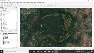
In this tutorial we export a google image and kml file from Google Earth Pro. The kml layer is then used in QGIS as the control points in georeferencing the image in QGIS.
Great tutorial - it worked! Then saved geotiff file in QGIS to import into Avenza Maps app to use out in the field. Key was changing the icons to get enable accurate georeferencing of control points.
All worked for me until the final bit and my points were all west of where I wanted them. I couldn’t find the snapping option- am on Hannover version - they must be elsewhere as there wasn’t a snapping options just options.
It could be a bug in the program. I would suggest uninstalling 3.12 and installing 3.10 instead. 3.10 is the latest most stable LTR version of the application.


Thank you for posting! Quick tip for those who could not find the Georeferencer under the "Raster" tab, check the "Layer"tab.
Thank you for pointing out the new location.
Great tutorial - it worked! Then saved geotiff file in QGIS to import into Avenza Maps app to use out in the field. Key was changing the icons to get enable accurate georeferencing of control points.
Thank you so much this is the best vedio of qgis georeferencing on UA-cam... Thank u so much it help me a lot.. 😍
YOU YES YOU
.
.
.
.
The one reading this. You are beautiful, talented, amazing and simply the best at being you. Never forget that.
Thank you for the great explanation. Learned a lot.
A wonderful tutorial. Thank you so much.
Thank you - was very helpful.
Good video, well explained...
Thank you so much for the tutorial!
Thanks, Ian - Excellent
Thank you, good work
Tq so much ,for your help
All worked for me until the final bit and my points were all west of where I wanted them. I couldn’t find the snapping option- am on Hannover version - they must be elsewhere as there wasn’t a snapping options just options.
I am facing the same issue with version 3.22. Lot's of the frequently used qgis tutorial options are difficult to find in the newer version
Thank you so much!!!!
very nice!
hello,
i have done everything but after pressing the "start georeferencing " key the map/image is disapearing ??
what do i do
Thank you for the video! I am using 3.12.3, but for some reason it will not import the KML file - any suggestions? Thanks again...
It could be a bug in the program. I would suggest uninstalling 3.12 and installing 3.10 instead. 3.10 is the latest most stable LTR version of the application.
Literally 1% people who read this message...
I pray your parents live more than 💯 years with good health