California State Highway 39 Bike Ride (Closed section)

Вставка
- Опубліковано 17 вер 2024
- Highway 39 was something of a engineering marvel when it was originally completed in 1960's. However, since 1978, the last 4.5 miles from Crystal Lake to Highway 2 have remained closed due to repeated damage from rockslides and snowmelt.
In December 2022, for the first time in 44 years, Caltrans has held public meetings to discuss the possibility or re-opening the nearly abandoned highway.
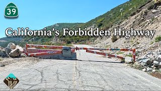
This week, I took my BPM Imports F-15 E-Bike up to Crystal Lake via Highway 39, where the road ends and the adventure begins.
I'll travel the entire 4.5 miles from Crystal Lake to Highway 2 and back and find out what kind of condition the road is in as well as how bad the damage really is.
Remarkably, as you'll see, Highway 39 is in great condition for being a 44 year old road. I suppose lack of vehicle traffic helps, and you'll even see Caltrans crews at times removing rocks out of the roadway in early stage preparation for re-opening.
We'll also pass by waterfalls and river water running next to and across the highway as this years record snowfall continues to melt off the higher peaks of the San Gabriel National Monument.
Whether you are curious about this "ghost highway", peddling on a home stationary bike or just need some work/study background noise, come huff it with me as I make the 1,600 feet climb in 4.5 miles.


Your video is the only one showing the last 4.5 miles of state route 39 in great quality. Amazing!
Glad you liked it!
ASTONISHING!!!! "Tim", . . . GOING UP: It's exactly like what it could have been, 100 years ago, driving a Ford Model-T. GOING DOWN: We'd need 5' minimum of snow--might as well have a blast schussing this on my SKIS! Looks like lobes of the horrible Bobcat fire probed here and there. Definitely National Park-calibre lands, as this highway rivals--sometimes surpasses--what you could find in the Sierra Nevada. Seeing the wind-flagging on some of these venerable trees tells me that the Santa Anas must EXCEED 120MPH up here! My gratitude has no bounds for what you've shared with us, Tim.
Loved this road was on it three times a week on my motorcycle from 1965 until it was closed 😊
Nice video. I remember driving this road while on a business trip back in 76. Quite the experience for a guy from perpetually flat Michigan. I was really disappointed that it was closed by my next trip, with huge boulders in the road just north of Crystal Lake.
Thank-you for filming to the other side of Hwy 39. Quite a rugged road.
Thanks for posting. This brought back many good memories!
Awesome video - best I’ve ever seen. (Ridden it many times). You rode the entire 5.9 miles and 1600 ft, the section closed since 1978 starts at the 8:43 mark when you pass through that open gate. They closed that lower 1.4 miles like 20+ years ago.
paesaggio spettacolare / amazing great view
Very cool Tim. I loved the view when coming down with the mountains on the right … San Gabriel Mountains are so awesome!
Loved this video. I’m afraid of height so this is probably the only way I’ll ever see this road. Would love to see you add a drone with camera to your videos.
Very cool video. I watched at X2 playback speed.
cool
California 39 is Beach Blvd in OC.
At 12:49, this area is covered with fallen rocks on google maps. Looks like they clean it up.
Cal-Trans has been cleaning it up both for regular maintenance and in anticipation of re-opening the road.
Very nice video
I am curious to know, how much does your battery recharge on a long downhill ? Thanks
On this particular bike, none. There is no regenerative braking on this e-bike unfortunately.
@@TimAlcoser Cool video thanks
Muy bueno
Thank you very much for uploading your video. What happens beyond the 30 minute and 15 seconds section where that gate stopped you from going further? I’m referring to the point where you turned around and headed back down.
That's the end of the closed section. It's where 39 connects to highway 2.
There is a parking lot on the other side of the gate across the 2 highway. You can hike up to Little Jimmy campground from that location. Because this road is closed, you would have to drive 2 hours on the 2 from La Canada to get to this point. If the 39 were to ever open that section again, it would save about an hour to drive to that junction.
The junction with highway 2, where 39 ends, is a couple hundred feet beyond that gate. Had he gone past the gate, he would have arrived at highway 2.
Been up there many times and CalTrans is just maintaining for emergency vehicles like fire trucks since that area is prone to fires. I hope they don't open it because all the traffic from Highway 2 will come down and ruin a peaceful area. Can you imagine driving down that Road and one of those massive boulders come down and crush a car full of people.
So interesting- Caltrains has plowed the snow from the road, and plowed the called rocks off the road. I want to ride this on a small dirt bike.. but I know it’s prohibited.
They are now planning on re-opening. www.google.com/url?sa=t&source=web&rct=j&opi=89978449&url=dot.ca.gov/DOT/caltrans-near-me/district-7/district-7-projects/d7-sr39-reopening&ved=2ahUKEwjdmoWH2oGGAxUcBUQIHXeVBFYQFnoECBQQAQ&usg=AOvVaw2aZLWMUbfdJYoiMHVvL3jf
@@TimAlcoser Don't hold your breath. These kind of promises have been made for decades now. But it would be amazing if they would do it-and alternative 4 should be the only option.
Why were there road repair workers on a road tat's been closed for 40 years? The road must serve some purpose? Thanks for video O:)
CalTrans may be opening the road back up in the near future. They conducted public meetings for comments late last year. But they also allow emergency and maintenance vehicles to use the road as a shortcut to highway 2.
The closed section of road is minimally maintained by Caltrans so that emergency vehicles can get to highway 2. The minimal maintenance has been done since it closed and has nothing to do with a possible re-opening. The closed section is used by LASD, LACOFD, ANF and San Dimas SAR. Tim is hopeful the road will open again, however I doubt it will be anytime soon.
The damage didn't look as bad as a documentary short I just watched made it sound. They said large sections were completely gone but it didn't look all that bad.
They also were worried about the preservation of big horn sheepin the area.
CalTrans allows us to use bike on this portion of SR39? I really want to try that out one day.
That seems to be the case. I passed by multiple Caltrans workers on the way up and multiple other people out enjoying the road.
There is signage stating closed to bikes and pedestrians at Highway 2. The signs at the south end gate have been ripped down.
@@mejbp That's what I saw as well.
I've done it many times. Never a problem, besides almost literally running into a black bear about dusk. Good thing I was going downhill.
Azusa canyon the road they use in Highway to heaven
Where do you park?
Crystal lake is just little further down from where the gate is.
@@arthurreyes2632by the food snack cafe?