First great, non-obvious presentation! Thank you! 11:00 blew my mind! Two questions: 1. Does the LiDAR Scanner always only fire one single pulse and waits until it returns, records it and only then fires the next pulse? 2. How is the pulse modulated/'made unique' so the scanner can recognize it again? Thx!
It will take a while to got thru your videos but planning on spending some time on the channel!! Can you provide me any advice on cost effective software for doing the post processing of the gnss/imu data? It has been very difficult for me get a good handle on exactly what software I have to purchase for the processing of the lidar data (ie post processing trajectory, and doing lidar strip adjustments). there seems to be so much to learn. Any advice you can offer will be appreciated. I can send you PM or email if that is better. I have Global Mapper + lidar module but I own no other lidar software. I mainly want to focus on providing DSM's and 3D models but over time I am sure there could be other venues that will generate income. Thanks for the great video and I look for any advice you can offer.


First great, non-obvious presentation! Thank you!
11:00 blew my mind!
Two questions:
1. Does the LiDAR Scanner always only fire one single pulse and waits until it returns, records it and only then fires the next pulse?
2. How is the pulse modulated/'made unique' so the scanner can recognize it again?
Thx!
Many thanks for the simple classic representation, good work. thumb up
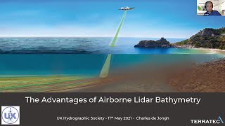
Great information here. Was very well explained.
Really enjoy your presentation n video. As I am on dauglas new book that using lidar for archaeology exploration
Very helpful video, thanks!
great, thanks so mush
jsut one question: why do we use green 532 nm or red IR 1064 nm laser? what happens if we use other wavelengths?
Green and Near Infrared are used because they reflect best off of vegetation
It was great!!!
It will take a while to got thru your videos but planning on spending some time on the channel!! Can you provide me any advice on cost effective software for doing the post processing of the gnss/imu data? It has been very difficult for me get a good handle on exactly what software I have to purchase for the processing of the lidar data (ie post processing trajectory, and doing lidar strip adjustments). there seems to be so much to learn. Any advice you can offer will be appreciated. I can send you PM or email if that is better. I have Global Mapper + lidar module but I own no other lidar software. I mainly want to focus on providing DSM's and 3D models but over time I am sure there could be other venues that will generate income. Thanks for the great video and I look for any advice you can offer.
Plain explanation. I am familiar with SLAR and realize it is pretty much the same principle
Aws0me inf0