If you'd like to ask me why the intro recorded from here, I thought that It will be a good idea for those work in the office area and not taking fresh air in whole day :)
very nice. I use sketchup to make terrain from google earth but when I import my model in archicad always in 2D I see the terrain( with a google picture on it ) in mirrored form.in 3D view it doesn't have any problem Can You plz help me to solve this problem?


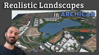


If you'd like to ask me why the intro recorded from here, I thought that It will be a good idea for those work in the office area and not taking fresh air in whole day :)
I Love The Technique , but how did you import the 3D object?
In order to be irreplaceable one must always be different. you are one !!!!!
Thanks :)
Good morning, one question: why cannot insert a 3d by google maps?
What a brilliant idea! this is useful in my company! Thank you!
It's nice to hear that :)
very nice. I use sketchup to make terrain from google earth but when I import my model in archicad always in 2D I see the terrain( with a google picture on it ) in mirrored form.in 3D view it doesn't have any problem Can You plz help me to solve this problem?
You nailed it
Thank you man. You just gave me a new idea 🤞👍
It's nice too hear that :)
merci pour le tuto. Bonne continuation.
can we import mesh in 3d from google earth or another website in order to create mesh automatically?
It's kind of tricky. Not in Archicad but there are some scripts for Blender and Max
Thank you teacher. You just gave me a new idea. Teacher, now show us how to design pool area retaining walls.
Great suggestion thanks.
Well done, very useful indeed.
Thanks for sharing.
Thanks bro
I can't save the file ?
HOcam başarılar dilerim. Archicad ile ilgili bi konuda desteğe ihtiyacım var. yardımcı olabilir misin acaba?
Very helpful.One Subscriber + for you 👍
You are very very perfect
Jos juragan your idea
amei!!