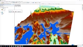
Prepare Flood Risk Simulation Map of an any Area in GIS

Вставка
- Опубліковано 28 сер 2024
- Welcome to Best GIS Tutorials.
Best GIS Tutorials is platform to help those people who want to develop their Skill we provide all the basics of Geographic information System From Beginner to Advance level such is how to georeference a map, how to digitize a map, how to download google earth image, how to download Satellite image for research, use of merge tool, how to make study area map, how to make layout for map. these are the some of basic and the main topics that we will provide in the form of tutorial videos and as well lecture in pdf form. Best GIS Tutorials is providing free opportunity to every students to learn and equipt will skills for a bright future.
Subscribe Best GIS Tutorials to understand Geographic Information System in simple way.
keep in touch with us.
=========================================
~~~~~~~~~ Subscribe our Channel~~~~~~~~~
How to Install GIS 10.5
• How to install arcgis ...
__________________
Basic GIS Course in English
PLDYyg9pTDkUqVd6ow-vYCwXSsLjBkCdu_
Gis Course in Urdu
• GIS complete Course in...
Advance GIS Lectures
• Advance GIS
Mapinfo Basic Course
• Mapinfo Basic Course
Erdas Imagine Basic Course
• Erdas Imagine Lectures
Basic ILWIS Software Course
• ILWIS Software Tutoria...
QGIS Tutorials
• QGIS Tutorials


😮
❤️
Sir from which site we downloaded DEM file
download it from USGS and earth data website