Student pilot's guide to cross-country flight planning with an iPad

Вставка
- Опубліковано 7 лют 2025
- Shop: www.sportys.co...
There is a wide range of opinions on how the iPad should be used during flight training by student pilots. On one extreme, some teach that students should only use paper sectional charts and perform all calculations by hand right up through the checkride, barring the iPad from the training environment.
Another camp follows the opposite logic, allowing students to use all the automated flight planning tools right from the start, bypassing instruction on the core techniques like preparing a navlog and flying a cross-country trip with pilotage and dead reckoning.
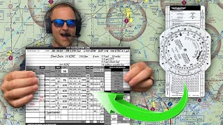
As with most things in life, the practical answer falls somewhere in the middle. It's important to learn how courses are plotted and groundspeed is estimated by using a plotter and E6B, but it's equally important to learn how to take advantage of modern tools like the iPad.
This can add another degree of safety and situational awareness when used properly. In this video, we'll show how the iPad and ForeFlight can be worked into the cross-country planning process as a digital chart viewer and resource to still fly a trip using pilotage and dead reckoning techniques.
Shop all pilot supplies: www.sportys.com/
Learn more about flying with the iPad: www.ipadpilotn...


I really wish you could add waypoints to your direct line without accidentally changing the heading by a few degrees.
You are able to, you just need to double check each time that it’s still the same course as it was before the waypoint was added in case you did move it a bit.
This method is what I use. ua-cam.com/video/sJ0lucy9QOw/v-deo.html its a little cumbersome to get the hang of but works well for me. Hopefully this helps!
@@MasCrPoothank you. Great tip!
Thanks a lot it was very useful really appreciate it great tip@@emtdocjoe
yes, putting the point say 25feet to the right of the line - and having to intentionally turn away from the line causing error - then to have to turn back to correct the error - is inconvenient. it is nicer stay right on course & makes a nicer lines when people look at my flying lines
This makes ForeFlight more appealing to me as many of the destinations for my Cross Country flights after getting my PPL go onto other sectional charts. This seems to simplify that process significantly.
I watched this because I did my check ride flight plan from Charleston to your location on paper. How convenient! I used river crossings for my points, easy to distinguish in the endless hills.
Must've done your Test with Bill Peters!
This is amazing and everything i needed. Fireflight update 16.2.1 included ATC sectional barriers. Game changer
ForeFlight is the greatest. I flew Part 121 international for 27 years. I fly my C206 all over. It is great.
My recommendation would be to select your first checkpoint about a mile or so after you have reached top of climb.
sounds pretty intense. i still use my standard gas station road map, saves money on buying them new fangled gps thingys
VFR sometimes seems more difficult than IFR XD
I tried putting in the waypoint name and you can not use spaces, caps, numbers, and some letters. Had a really hard renaming the points I selected. I do not think you can do this in Foreflight - well at least for the version I have.
What time button?
Does foreflight offer recommended flight paths or have warnings about TFRs or Bravo airspaces along the way? It's ultimately up to the pilot to handle of course, but would be a nice feature for flight planning software. Especially if you're not using flight following and actually plan to follow your flight plan. btw great video, I haven't done an x country flight with foreflight yet, so this was helpful - thank you for sharing!
Foreflight does have an option to highlight TFRs and outlines airspace as well as future TFRs
The 3D profile view (in the FPL window at the top of the Maps page) is great for this.
most DPE’s wont let you use for flight, in fact many flight schools wont let you use forflight and make you use paper charts for the private rating.
I use paper charts and Foreflight. I seem to like paper.
that’s just not true
@@bobjofinn12345 Yes, it's true. However, they just changed the ASC that is effective 5-31-24 that allows EFB. So now they are allowed however, the DPE more than likely will turn off the GPS tracker in Foreflight. You need to be able to fly your self out of the paper bag and not have to relay on GPS for finding your way around. On the other note, Foreflight is handy using as a TAC chart. So much easier to deal with than the paper charts taking up so much space in the flight deck. However, have a back-up paper map. You can also measure quickly with your hand for the time and distance problems when you do your diversion.
How do I get the names of the Waypoints to show up in my navlog?
She has her head down on that Ipad for to long.
The directions on creating way-points is all wrong. You have to make the way-points first. Also, they do not show up in the nav log. You have to hand-write the way point names in the navlog. Please do not spread fake-news like this. I just followed your inaccurate instructions and the way-point names do not appear in the nav log. Nobody at my flight school is able to name the way points they way you demonstrated. So not sure what you are smoking. Also, not everybody has a C-172. You have to go in manually to set-up your profile based on your aircraft AFM or operating handbook. You make it sound so simple. Well it's not. Hope you are more careful with your flying.
You should be using an E6B and paper until you get an instrument rating, all this tech makes pilots lazy, and they are up a creek when it all fails.
I use my E6B wiz wheel and paper chart and use Foreflight to help me zoom in on finding way points that I am going to select. I word to memorize the way points so I an keep my eye balls outside of the flight deck.
Isn't the E6B making pilots lazy too? (just joking)