This is indeed a truly great training video on reading weather charts! It is the best there is from pilot's perspective! It is so hard to find good and simple resources out there on how to read and understand aviation weather; you so perfectly explained how this can be done and I really learned so much. From someone as myself that has always struggled with reading aviation weather, this training video certainly helped me understand and explained specifically what pilots need to know to be able to read and plan flights with weather charts. Thank you so much for making this video and I look forward to your future videos to learn from. You truly are a great inspiration and an excellent teacher / trainer for all pilots and controllers!
So tired of watching flight videos! Cant wait till I can get a gamer pc and xplane 11 and join y'all for fun! You will be one of my main instructors! Great job!
Excellent video, excellent explanation! To put in practice right away. Thank you so much! Just an easy question: in the vertical profile chart, how is supposed the direction of wind be read?
Thanks, good question! You can see the little compass roses on top, you are flying in the direction from left to right, so the wind barbs kinda portray the same way. In this case, we have mostly tailwind, and upon our decent it becomes more of a wind from our 4-5 o'clock. You can check this legend too: www.rocketroute.com/wp-content/uploads/2020/06/Vertical-profile-strong-winds-2.png
The general weather refresher was more useful than I initially was thinking. Been a long while since I turned on a news broadcast to catch the weekly weather forecast. EDIT: One edge case I see there, what is equatorial weather like in terms of the general rotation of high/low pressure systems? Is the difference sheer, or mixed results depending on season, or is another mechanic?
This video for me is useful.I have used SimBrief for many years.I use it for my fsx flight plan,but I don't understand what are the symbol that showing on Sigwx.After I saw your video.Now, I can understand what are they means.
Thanks these videos help me alot! Your channel has helped me get started on vatsim (finally) and just learn the basics of flying online. Even though I'm on a completely different sim (Xplane). So thank you! Also just something I've always wondered, have you ever tried x Plane? If no why not? Hope to see you in the virtual skies!
When I get briefs online (I'm not a pilot but use 1800wxbrief, DUATS and one other website, iflightplanner, without actually ever filing a flight plan [that'd be bad]) I notice they don't seem to do much in the way of forecasting. Like 24 hours to 30 hours from now we should be getting snow in Connecticut. But I planned a flight from KBDL to KOXC , said I'm leaving in 29 hours and didn't get a mention of snow in all the brief products. Many of which were not avaialble. I think I selected the predictive type for 'route' with a 50 nm radius around the route. Also hallo, and tot ziens. :)
It probably really depends on the program you use, I am not familiar with the ones you mention, but in general when I am using Simbrief, PFPX or Rocketroute I get accurate weather predictions ;)
That is good :) I take it maybe you are from outside the USA right? Well I want to just recommend the free trial (it's Windows-Only and if you have Win 10 or later than 8.1 might want to run compatibility diagnostic on it to get the right version) Atmograph . It has access to like *every* weather model that covers North America, and even those like GFS which cover the whole globe, and not only that but you can look at any product offered by these models, visually. Instead of just data or poorly visualized data. This includes icing for example at not just 500 or 850 mb, but 50, 100, 150, 200, etc.. lol. It's really detailed. Thank you for the reply. :)
In an occluded front, since the cold air overtakes the warm air, does that mean there could possibly be hail since an occluded front can have thunderstorms?
Hey! I just got the PMDG 737 and I'm having a hard time getting it started and understanding what I'm doing. So would there be any chance you could make on a cold and dark start up tutorial? (I know there are others but I'd be interested to see what your take is on it.)
I know there are so many different versions of 'cold and dark' start ups out there ... but yes, keen and very interested on a video on how the recommended way is done.
Make sure you check out my NEW Weather Radar Tutorial! On how to use the weather radar systems in airliners and how to avoid thunderstorms properly: ua-cam.com/video/c83k1Zttxpw/v-deo.html
06:30 I think it is the other way round. Warm front's weather is moist, clouds, rain and cold front is thunderstorm, clear sky. www.eduplace.com/science/hmxs/es/pdf/5rs_3_8-4.pdf
I think he's got it right because since the equator is logically the honest area on the earth it is known to form a lot of tropical storms. So it would validate that warm air there causes thunderstorms but don't quote me on this because I said I think, so I'm not 100% sure
Sorry but cold fronts are associated not only with high wind speeds but also with thunderstorms and windshears. This is because the passage of a cold front creates a lifting force that helps develop cumulus clouds ( Cu, Cb). As for the warm front, we experience a lowering cloud base/ poor visibility at low levels due to subsidence and the pressure falls.The wind also veers ( turns clockwise ) in the Northern Hemisphere. Conclusion, cold fronts usually produce heavy/severe thunderstorms and warm fronts typically are associated with only light winds and rain although the possibility of a thunderstorm exists.
Hello. I liked your video, very informative. :-) You say in the video that rocket route is free, but I think it's just a 14 day free trial, am I correct? :-)
Thank you! Well I think you can try all the full functions for 14 days for free, after that you only have limited options but still quite fun for flight simulator.
AviationPro Thanks for replying. :-) The weather charts are a very nice tool. If they are still available after the 14 days trial I'll surely use rocketroute more.
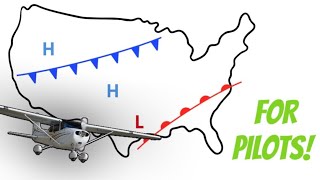
1013 is the standard pressure. So anything below this is considered low pressure, everything above is high pressure. If you see L and H next to the 1013 pressure it could simply be that that area is like 1013.2 or 1013.8 respectively.
Crossing a front 6:15 "It's not really that important" Careful, you can get your ass kicked very badly crossing a front. Usually a storm or rain and wind bad vis. is going to be associated with a cold front. Slower moving warm fronts can be similarly hazardous. Pilots looking for actual, non-simulator weather information should take great caution with this statement. Wait until the front - passes and then go. Otherwise pretty useful.
It was pretty hard to follow what you are saying and trying to show on the charts. You have your pointer at the smallest size .. Its literally like a black dot running around in a black and white background. No idea where you are indication. Things like "it goes from here to here" it makes no sense! These are some of the basics you need to get right of flight instruction!!

![7 Tips To Make a GOOD Manual Landing! [P3D]](http://i.ytimg.com/vi/joOI4X5Vka8/mqdefault.jpg)
![7 Tips To Make a GOOD Manual Landing! [P3D]](/img/tr.png)


Hi all, thanks for watching this video! There's a small mistake in the video. 1013 hPa equals 29.92 inches, NOT 22.92! ;)
AviationPro Kind of figured the correction. No biggie. Thanks for the review. My PPL check ride is this weekend and I needed this refresher.
Study some geography man. West of Spain?
Hello. Boeing 777 pilot here. I use these charts every flight, but find that a review of symbology is still useful from time to time. Great review!
Awesome! Thank you! :)
same symbols in Crop circles
This is indeed a truly great training video on reading weather charts! It is the best there is from pilot's perspective! It is so hard to find good and simple resources out there on how to read and understand aviation weather; you so perfectly explained how this can be done and I really learned so much. From someone as myself that has always struggled with reading aviation weather, this training video certainly helped me understand and explained specifically what pilots need to know to be able to read and plan flights with weather charts. Thank you so much for making this video and I look forward to your future videos to learn from. You truly are a great inspiration and an excellent teacher / trainer for all pilots and controllers!
Thanks a lot Chris! :)
Congratulations Leshao Leshao, you never disappoints me and the youths generally. Ilepu neija
This is what our people need, information about weather. Thank you!!
Glad to hear that, thanks for watching! :)
PPL student here, will be doing my exams next weekyou cleared out questions I had for too long, dankje wel!
Ah wat tof, veel succes! En see you in the sky ;)
For beginners, its very good explanation. I liked it.
So tired of watching flight videos! Cant wait till I can get a gamer pc and xplane 11 and join y'all for fun! You will be one of my main instructors! Great job!
Thanks, have fun! :)
Goed je weer terug te zien.
Thanks ;)
Thanks for the video! Really helped me with my PPL Meteorology test :)
Thanks for the video, been looking for some insight on how to understand and read weather charts, so you video is perfect timing.
I'm glad to hear that, thanks for watching! :)
Great video thanks, subscribed.
Very good explanation. Congrats! Cheers from Brazil.
Thank you!
Very helpful reminder of wx for my upcoming ckride. Thank you!
very nice and informative Video...thank you so much for your big effort to make such video..danke schön.....
Thanks for watching!
FANTASTIC!
Absolutely helpful as usual😃
(waiting for a new VATSIM full flight BTW😉)
Thanks! Yes, I'm planning on making one soon ;)
Thank You for choosing LZIB in the example, nice to see my home airport in a video.
You're welcome! :)
Thank you so much. Very good explanation.
You’re welcome!
Great video. I learned a lot about wedder.
Good explanation
Thank you! :)
Great video! Really refreshed my memory! Been quite a while since Atpls!
Thanks!
1013hpa = 29.92 in, not 22.92
1013.2 =29.92
I was gonna say the same thing. You see 22.92 and you better pray you survive lol
I wish if you used color pointer , easy to follow .
Thank you so much.
Excellent video, excellent explanation! To put in practice right away. Thank you so much!
Just an easy question: in the vertical profile chart, how is supposed the direction of wind be read?
Thanks, good question! You can see the little compass roses on top, you are flying in the direction from left to right, so the wind barbs kinda portray the same way. In this case, we have mostly tailwind, and upon our decent it becomes more of a wind from our 4-5 o'clock. You can check this legend too: www.rocketroute.com/wp-content/uploads/2020/06/Vertical-profile-strong-winds-2.png
Thanks for the video, it was indeed very useful,explanation simplified.
Thank u for the video man.. Merry Christmas
You're welcome, you too! :)
Very good. :)
1013hpa are 29.92 inches
Thanks! Yes, that's correct.
The general weather refresher was more useful than I initially was thinking. Been a long while since I turned on a news broadcast to catch the weekly weather forecast.
EDIT: One edge case I see there, what is equatorial weather like in terms of the general rotation of high/low pressure systems? Is the difference sheer, or mixed results depending on season, or is another mechanic?
Thanks for taking the time to help educate us. Great video.
You're welcome, thanks for watching! :)
This video for me is useful.I have used SimBrief for many years.I use it for my fsx flight plan,but I don't understand what are the symbol that showing on Sigwx.After I saw your video.Now, I can understand what are they means.
Glad the video helped! :)
Oh my god thank you! So helpful.
Great job bro and excellent explanation very thorough and useful thanks !
Thanks!
Thank you. I’m sitting for my dispatchers oral and practical.
Good luck! :)
Hi thank you for this information I appreciate it so much I was looking for this kind of lesson
Thanks these videos help me alot! Your channel has helped me get started on vatsim (finally) and just learn the basics of flying online. Even though I'm on a completely different sim (Xplane). So thank you! Also just something I've always wondered, have you ever tried x Plane? If no why not? Hope to see you in the virtual skies!
You're welcome! Yes I have tried X-plane (10), but only because someone invited me to ;)
AviationPro
Ha fair enough. Do you fly for a VA btw. Just wondering :)
No ;)
many thanks for video, it was very constructive
You’re welcome!
please add soundproofing to the room you use for recordings....
Fantastic job man. Thank you very much as usual
Thanks! :)
Fantastic explanation! Thank you very much!
You’re welcome! :)
When I get briefs online (I'm not a pilot but use 1800wxbrief, DUATS and one other website, iflightplanner, without actually ever filing a flight plan [that'd be bad]) I notice they don't seem to do much in the way of forecasting. Like 24 hours to 30 hours from now we should be getting snow in Connecticut. But I planned a flight from KBDL to KOXC , said I'm leaving in 29 hours and didn't get a mention of snow in all the brief products. Many of which were not avaialble. I think I selected the predictive type for 'route' with a 50 nm radius around the route. Also hallo, and tot ziens. :)
It probably really depends on the program you use, I am not familiar with the ones you mention, but in general when I am using Simbrief, PFPX or Rocketroute I get accurate weather predictions ;)
That is good :) I take it maybe you are from outside the USA right? Well I want to just recommend the free trial (it's Windows-Only and if you have Win 10 or later than 8.1 might want to run compatibility diagnostic on it to get the right version) Atmograph . It has access to like *every* weather model that covers North America, and even those like GFS which cover the whole globe, and not only that but you can look at any product offered by these models, visually. Instead of just data or poorly visualized data. This includes icing for example at not just 500 or 850 mb, but 50, 100, 150, 200, etc.. lol. It's really detailed. Thank you for the reply. :)
Derp, you're Dutch - hence my casual Dutch use in the OP... losing it lol. Cya later.
Haha, that’s right :) Thanks for the tip! :)
I have a question about the wind speed does the wind direction move in the direction of the triangle or the direction of just the stick
9:06
Thank u so much. It helps a lot
Very good explanation
Thanks a lot
You're welcome!
This video was extremely helpful for me!
Thank you!
Subscribed
Thanks!
Amazing video, helped me alot!
Hi great vid.. what are those random letters on the charts? Like the W or M
Those are simply cities, you can see Madrid and Amsterdam for example :)
@@AviationPro thanks so much
Brilliant. I am a pilot and i endorse this video.
Thanks! :)
Hello, i really enjoy watching your video. However i wanted to ask you more about the CAT areas... thank you
this video helped me to understand. 100% good T
Thanks I am beginnen as loadmaster next week very usefull
You're welcome!
Nice work
Thanks!
Please can someone provide me a link to download the PDF document on aviation weather chart
can we see a sign about tropopause in sigwx chart? and if yes, how we can read it? please answer
You should be a teacher :P very good video. Even though i know how to get the info i need, this is awesome. Thanks!
Haha, thanks! :)
In an occluded front, since the cold air overtakes the warm air, does that mean there could possibly be hail since an occluded front can have thunderstorms?
Very hepful. Thank you
You’re welcome!
29.92inch~!
Thank you very much it was very useful for me
You're welcome! :)
great video
Thanks!
Helpful!, thx.
Great Video,Very Informative,Big Like!!!!
Thank you! :)
Very good info!
Thank you! :)
Hey! I just got the PMDG 737 and I'm having a hard time getting it started and understanding what I'm doing. So would there be any chance you could make on a cold and dark start up tutorial? (I know there are others but I'd be interested to see what your take is on it.)
I'll think about it, but what you will see from me will probably be very similar to those other tutorials ;)
Haha that's ok!
I know there are so many different versions of 'cold and dark' start ups out there ... but yes, keen and very interested on a video on how the recommended way is done.
Thanks Bro
Nice video
Thanks!
Make sure you check out my NEW Weather Radar Tutorial! On how to use the weather radar systems in airliners and how to avoid thunderstorms properly: ua-cam.com/video/c83k1Zttxpw/v-deo.html
Thanks ! Like and suscribed amigo
Excellent, thank you!
You're welcome!
06:30 I think it is the other way round. Warm front's weather is moist, clouds, rain and cold front is thunderstorm, clear sky.
www.eduplace.com/science/hmxs/es/pdf/5rs_3_8-4.pdf
I think he's got it right because since the equator is logically the honest area on the earth it is known to form a lot of tropical storms. So it would validate that warm air there causes thunderstorms
but don't quote me on this because I said I think, so I'm not 100% sure
Great video.
Thank you! :)
Cool vid, thanks!
+pankracy111 Thanks for watching! :)
isnt average sea level preasure 29.92? inches of mercury
Thanks, l needed that, thumbs up
You're welcome!
Sorry but cold fronts are associated not only with high wind speeds but also with thunderstorms and windshears. This is because the passage of a cold front creates a lifting force that helps develop cumulus clouds ( Cu, Cb).
As for the warm front, we experience a lowering cloud base/ poor visibility at low levels due to subsidence and the pressure falls.The wind also veers ( turns clockwise ) in the Northern Hemisphere.
Conclusion, cold fronts usually produce heavy/severe thunderstorms and warm fronts typically are associated with only light winds and rain although the possibility of a thunderstorm exists.
Thanks for your input! :)
No problem!
Continue your great work! :)
Thank you !
You're welcome! :)
very helpful!
THANK YOU!!!!
You're welcome!
great video ........
Thanks!
thanks
You're welcome!
Hello. I liked your video, very informative. :-) You say in the video that rocket route is free, but I think it's just a 14 day free trial, am I correct? :-)
Thank you! Well I think you can try all the full functions for 14 days for free, after that you only have limited options but still quite fun for flight simulator.
AviationPro Thanks for replying. :-) The weather charts are a very nice tool. If they are still available after the 14 days trial I'll surely use rocketroute more.
but also thanks for video. It helps me to understand the weather charts
Yes thank you, I have added an annotation to correct it ;). Thanks for watching! :)
12:05 does 1013 standard mean low or high pressure??? here it says bith
1013 is the standard pressure. So anything below this is considered low pressure, everything above is high pressure. If you see L and H next to the 1013 pressure it could simply be that that area is like 1013.2 or 1013.8 respectively.
Thank god I took calculus, slope field clutches up
wow same symbols found in Crop Circles
29.92A
I know ;)
Nicee.
jet stream 16:00
29.92 inHg*
Interesting
Thanks!
Standard inches of mercury is 29.92 not 22.92. Otherwise good video!
29.92 not 22.92.
I corrected it using UA-cam annotations, but then they decided to remove it :( But indeed, it's 29.92 :)
Crossing a front 6:15 "It's not really that important" Careful, you can get your ass kicked very badly crossing a front. Usually a storm or rain and wind bad vis. is going to be associated with a cold front. Slower moving warm fronts can be similarly hazardous. Pilots looking for actual, non-simulator weather information should take great caution with this statement. Wait until the front - passes and then go. Otherwise pretty useful.
jimflys2 you are absolutely right! Cold fronts are also associates with thunderstorms ⛈ clearly cold fronts are more dangerous than warm fronts
You really could do with a more prominent screen pointer :-(
Will do for next time ;)
ok?
What?
Stop doing these tutorials and do full flight videos with PMDG 777
You are on the wrong channel if you are looking for boring 777 (which I don't even have) long-haul flight videos without any educational value.
bye
Bye! :)
It was pretty hard to follow what you are saying and trying to show on the charts. You have your pointer at the smallest size .. Its literally like a black dot running around in a black and white background. No idea where you are indication. Things like "it goes from here to here" it makes no sense! These are some of the basics you need to get right of flight instruction!!
I know, not much I can do about it now though. And remember, this video is for flight simulation only, not real world flight instruction!
🫶🏻🫶🏻
"West of Spain"?
Good with weather charts, horrible with geography!
Very explanatory video. Thank you!
Thanks ;)
Thank you very much!
You're welcome!