Hey guys! I hope you had a wonderful valentine's day and I hope you enjoy today's video. Do not forget to check out skillshare as only the first 500 people who click this link will get 2 free months of Skillshare Premium: skl.sh/survivingarchitecture11 I love you guys so much and I hope you have an amazing weekend.
Top tip: If you open the PDFs in illustrator first, you can more easily select text and individual elements (like the digimaps watermark) and remove them (or re-colour them) with a bit more presicion and speed. Great video! 🛠
Thank you for posting this! We, architecture and urban planning students, need to be more united and help each other more! You have so many videos that helped me a lot, im REALLY thankful!
Omg😍I started a new project last week and I’m going to do the site analysis today. It’s so lucky that I can watch this video before I start to work! Thanks so much!!!
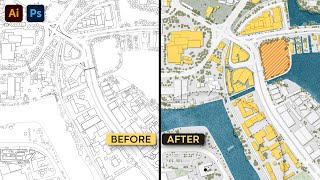
a perfect demonstration of site analysis - we use digimap all the time and I never knew that by selecting the vector district map I would get these extra layers that I could turn on/off although I think they used to have this feature separately but great video
This is a great video. I am learning to do site analysis as an architectural student and this was lifesaver. Could you share the website that you find info about the heritage asset?
Literally I am crying watching this at 0.25 speed coz I can’t work it out what she is doing! How the hell does she get each circle thing onto each layer it’s driving me crazy 😭
Hmmm I suppose it would be the same process but only turn them to axono in the beginning when creating the base. But I will definiately keep that in mind for later videos :)
is there a more in depth video that explains the photoshop process more slowly as i am not familiar with a lot of the photoshop processes which meant a lot of rewinding and googling
2019 has been a hard year for me 2020: *laughs* BTW awesome content...Love your way of explaining things in an easy manner, just not having access to the Digimap is annoying😁
Just woke up and went straight in!! Thank you for another great stuffs and the link to skillshare!! I have one question thou..... is there other sites (other than cadmapper or google) than digimap with worldwide map data that is exportable? Again, thank you for these video~!!
This tutorial is so informative, I have a query : Which saving file format would give better printing quality of these kind of architecture renderings JPEG or Photoshop PDF, Which one to go for 'save as' in photoshop, Thank you
@@SurvivingArchitecture could you share the settings, recently I had my Thesis Jury then, After print I could see no water color effects which I have rendered on my sheet. I thought I did some mistake.Anyway THANKS FOR REPLYING TO MY QUERY, KEEP UPLOADING YOUR WORK , I have been your subscriber👍
Hi guys, That is amazing video, but i am having trouble with the layers. The maps download from digimaps does not appear as layers at it is shown on your video. Would be amazing if you could explain how to export the file and import to photoshop step by step. Thanks!
When you select the digi map watermark, what do you do? i.e do you do content aware? white? or just delete it (transparent back)? Also, where do you find your area action plan? LOVE YOUR VIDEOS! Literally saving my degree!
It's completely up to you if you want to delete it or color with white but I deleted mine. If you write in Google "xxx area action plan" and replace xxx with your city, it should come up. If not you'll need to look around planning application website. Hehhe thank you so much! ❤️
Hi, for the "land use" diagram, what's the content? One of them I can't see cos it's so small. "Residential" "Commercial" "Retail" "Infrastructure" "Health" "Educational" "Car park"... Can't see one of them.. the one that's in between "Infrastructure" and "Health". I really like your videos btw, very straight forward and easy to follow.
Any diagram is better done on illustrator for higher resolution and cleaner lines. That being said, the best program for you depends on which one you feel most comfortable with.
Your video is really great but I’m struggling in the first section. When you generate and open the pics it keep opening the pics in different layers instead of all on the same page did I generate it wrong or save it wrong please help me 🥺😊
@Surviving Architecture :( Only for UK students, that's a pity!, Your channel is incredible and really useful! , Do you know a software like that but in Mx?
Having problems with trying to get rid of the digimap water mark. Is there no easier way? I have to go through and it takes a very long time in colouring bits ive had to erase
if you have photoshop open on half the screen and the folder where you exported the files on the other half just select all the files u need then drag into photoshop. it will ask you to confirm each file one by one so they wont all show at first. youll need to click the tick at the top for each one. Files were exported in PDF :)
Can I ask about some technical things? You can download smth if you are logged in? But you can log in only if you are on the list of service digimap? Beceuse I can`t logg and don`t understand what I`m doing wrong.
temitope akinsiku if you were to do this in illustrator, the file would be vector (lines) rather than raster (pixels). Also with illustrator you have a feature where you can remove the watermark in one go.
As Jan said, the end images will definitely better quality if done in illustrator. For pixeled lines in photoshop, you can sharpen using sharpen filter and avoid turning smart objects to rastered images. Since I know the size I will be printing these is small so little pixels don't bother me as when it's printed, its still high quality :)
Hello Professor, Apologies I don't know your real name. I noticed not all basemap gives the same map content. For example, raster 25K has paths and public access but if I choose vector map district, the map content does not stay the same as raster 25K. Also after you exported all images into photoshop, did you get the big logo in your exported images. If so, how do you get rid of the logos? Thank you very much. You are a great teacher:)
I'm not sure about the map contents as I haven't tried exporting in different styles. For the logo, I used the magic wand tool to select it and delete it from all of the layers.


Hey guys! I hope you had a wonderful valentine's day and I hope you enjoy today's video. Do not forget to check out skillshare as only the first 500 people who click this link will get 2 free months of Skillshare Premium: skl.sh/survivingarchitecture11
I love you guys so much and I hope you have an amazing weekend.
So Did you liked 2020 hhhhhh. i'm talking to you from the FUTURE...
Top tip: If you open the PDFs in illustrator first, you can more easily select text and individual elements (like the digimaps watermark) and remove them (or re-colour them) with a bit more presicion and speed. Great video! 🛠
Yesssss! Thanks for the tip!
I literally finished my site analysis yesterday which took me about 3days to make. I feel like I need to redo it after watching this video xD
Samee heree T.T
im an urban planning student and this has helped so much to produce high quality maps for my design proposals !! thank you :)
Happy to help!
Thank you for posting this! We, architecture and urban planning students, need to be more united and help each other more! You have so many videos that helped me a lot, im REALLY thankful!
Happy to help!
I am currently doing my first year in architectre and thank you so much it saved me so much time creating my site analysis.
Currently, doing my masters. This is so useful! So glad to have found your channel before my thesis.
Glad you found it helpful!
Recently started first year in architecture, with very little knowledge of photoshop. This tutorial has been amazing thank you!
MY BOI ALEXI
BIG UP THE ARCHITECTURE STUDENT REP!!
Omg😍I started a new project last week and I’m going to do the site analysis today. It’s so lucky that I can watch this video before I start to work! Thanks so much!!!
oh wow glad to know it came in the right time!! :) Thank you for watching!
This is really going to save me time and make it look like I put in so much effort. Thanks!!
That's the whole point! I'm glad ❤️
It’s perfect to see that video before making site analysis i was spending my one week to finish them 😂😂
Perfect time!
My life? You saved it. My time? You've saved it. My class? You've saved us lol
hahaha thank you for saying that. It means a lot!
Love your work. Your efforts are so much appreciated. And your delivery and calm manner makes watching the videos a pleasure.
Thank you very much!
Oh my god. I could have looked up this tutorial. I've been screwing up architecture school for ages. This helps a lot. Thanks!
Happy to help ☺️
a perfect demonstration of site analysis - we use digimap all the time and I never knew that by selecting the vector district map I would get these extra layers that I could turn on/off although I think they used to have this feature separately but great video
Glad it was helpful!
im just starting to learn photo shop to make my work more profesional nd this has really helped me up my game and was very eary to understand
Site analysis videos are always so useful!!
Glad you think so!
This is a great video. I am learning to do site analysis as an architectural student and this was lifesaver. Could you share the website that you find info about the heritage asset?
Great work. Worse case scenario, ask a GIS Analyst/student to make you one or tell them to export into a vector so you can edit in illustrator
Great idea!
Thank you! Big help towards my MA Urban Design projects
prefer the chit-chatty haha. truly inspirational. stay safe!!!
Hahaha thank you so much!
How to register in digimap....or how to use cadmapper for site analysis like in this video...the video was really awesome 🔥
You will need to have an account with digimap. Maybe will do a video in the future with Cadmapper. Thank you so much!
Happy valentine day to you too :) Very nice video thank you :)
Thank you for watching!
Really nice, very interesting topic - more Like this would bei awesome
Especially the smart tips are great and completly helpful. For example the Transport Analysis with google or the Last diagram.
More to come!
Thanks you so much for the video..You literally saved my life..
Glad it helped!
I didn't know that selection method you showed in the landuse diagram, and I will definitely use it! Thank you for the tips!
Thank you for watching! You are most welcome
This video would have been so useful to me two months ago!
still useful today :) Thank you for watching!
That’s really good inspiring video!
Thank you so much!
wow really awesome thank u for that simple explained tutorial :)
Thank you for watching ☺️💛
This video is really awesome. Thanks!
Thank you for watching!
I love your voice ! 😂 and thanks for the helpful tutorial video.
Thank you. Glad you thought it was helpful!
How did you enter the page? I can not without an institution that is subscribed
Nice!.this was similar to the previous one....been a long time since previous video!!
Thank you for watching!
This is great for me. Tks so much !
You're most welcome!
Your videos help me so much
You are most welcome! Thank you for watching!
This video is really awesome.
Thank you for watching!
the clipping mask thing is too confusing do you have a video on how to create clipping masks and add layer masks in to the layers ?
Literally I am crying watching this at 0.25 speed coz I can’t work it out what she is doing! How the hell does she get each circle thing onto each layer it’s driving me crazy 😭
Any chance of doing a video showing how to create diagrams in axonometric view? Instead of it being plan view?? Love the video though, very helpful 👍🏻
Hmmm I suppose it would be the same process but only turn them to axono in the beginning when creating the base. But I will definiately keep that in mind for later videos :)
Firstly thanks a lot , learnt a lot from you 👌🔥 will be really helpful if you slow down a bit 😁
Thank you for watching!
I love your style so much ❣️
I didnt know I had a style but thank you so much!
please can you do a tutorial on how to do this with google maps? love your content its really insightful
Great idea!
Omds Era! Great video !!
Thank you so much!
The video was so amazing.
Thank you so much!
Great work. Thank you so much
Thank you for watching!
is there a more in depth video that explains the photoshop process more slowly as i am not familiar with a lot of the photoshop processes which meant a lot of rewinding and googling
exactly! I’m new and this looks good but too fast :(
thankssss a lot this is wonderfull
You're welcome 😊
This is so helpful
Glad you think so!
You are amazinggggggggg❤️❤️❤️
Thank you!
@@SurvivingArchitecture اهلا وسهلا👌🏻👌🏻
2019 has been a hard year for me
2020: *laughs*
BTW awesome content...Love your way of explaining things in an easy manner,
just not having access to the Digimap is annoying😁
Thank you! Have you tried Cadmapper?
@@SurvivingArchitecture Yea I'm using that rn. But digi has a lot of contents
i love the little inflection crack in your voice
Heheheheh where?
This is so helpful, I’ll keep this in my urban project😂
You are most welcome!
Nice and long video i really knew what you where doing.
Thank you for watching!
heyyy, nice job.
I have a question, how do you get acess to digimap if your university does not figure out in the liste?
Yeah i have thesame problem ☹️
Just woke up and went straight in!! Thank you for another great stuffs and the link to skillshare!!
I have one question thou..... is there other sites (other than cadmapper or google) than digimap with worldwide map data that is exportable?
Again, thank you for these video~!!
Thank you for watching! hmm I don't know really any other free ones but I will have a look around
Can you make a video on how to scale all of these maps? AKA, make a scale at the end of the finished product
This tutorial is so informative, I have a query : Which saving file format would give better printing quality of these kind of architecture renderings JPEG or Photoshop PDF, Which one to go for 'save as' in photoshop, Thank you
PDF is always going to be the better option. Most my profs only accept PDF files.
@@MrRudderbucky Thanks a lot for replying to my query
Both JPEG and PDF will have good quality depending on the settings you save it in. However PDF will have a larger file size.
@@SurvivingArchitecture could you share the settings, recently I had my Thesis Jury then, After print I could see no water color effects which I have rendered on my sheet. I thought I did some mistake.Anyway THANKS FOR REPLYING TO MY QUERY, KEEP UPLOADING YOUR WORK , I have been your subscriber👍
Hi guys, That is amazing video, but i am having trouble with the layers. The maps download from digimaps does not appear as layers at it is shown on your video. Would be amazing if you could explain how to export the file and import to photoshop step by step. Thanks!
When you select the digi map watermark, what do you do? i.e do you do content aware? white? or just delete it (transparent back)? Also, where do you find your area action plan? LOVE YOUR VIDEOS! Literally saving my degree!
It's completely up to you if you want to delete it or color with white but I deleted mine. If you write in Google "xxx area action plan" and replace xxx with your city, it should come up. If not you'll need to look around planning application website. Hehhe thank you so much! ❤️
Your voic is beautiful I loved it
Thank you so much!
We love longer videos.
Will do more for you 😉❤️
If you have access to CAD site plans, illustrator is much quicker process
I've tried it in illustrator but It was slower for me.
LOVE IT
Thank you so much!
Hi, for the "land use" diagram, what's the content? One of them I can't see cos it's so small.
"Residential" "Commercial" "Retail" "Infrastructure" "Health" "Educational" "Car park"... Can't see one of them.. the one that's in between "Infrastructure" and "Health".
I really like your videos btw, very straight forward and easy to follow.
Do you mean Faith? Thank you so much!
Thanks a lot!
You're most welcome
I didnt know about the layers on digimap thats mad
Thank you for watching!
Which application is better on drawing site analysis, illustrator or photoshop?
Any diagram is better done on illustrator for higher resolution and cleaner lines. That being said, the best program for you depends on which one you feel most comfortable with.
شكرا جزيلا تعلمت منك كثير
You are most welcome!
U are really awesome...can you make presentation sheet in context to 3d drawing...n can u give the link to download illustrator
Thank you so much!
thx queen
You are most welcome queen Veronica ❤️
Digimap is only in the UK right? What if we are not from the UK?
You can use Cadmapper or Google Maps
WNice tutorialch version do you use to get all the setup and polyphonic softs?
I mainly use it for the plans and I go over it to do the analysis.
Your video is really great but I’m struggling in the first section. When you generate and open the pics it keep opening the pics in different layers instead of all on the same page did I generate it wrong or save it wrong please help me 🥺😊
Are you openning them in seperate documents?
i can not understand where the circle dissapears, what do i do then, everything until the masking is fine, but then what to do ?
@Surviving Architecture :( Only for UK students, that's a pity!, Your channel is incredible and really useful! , Do you know a software like that but in Mx?
Thank you! Have you tried Cadmapper?
Having problems with trying to get rid of the digimap water mark. Is there no easier way? I have to go through and it takes a very long time in colouring bits ive had to erase
have you tried color range?
Why not use ARC GIS and generate factual maps....?
Hello! could you please tell me how to generate factual maps? this can save me a lot of time!
@@nesknesk4767 You need to learn ARC GIS for that. What is your site location?
@@ethanhunt2570 I already use ArcGis :) but I lack updated shapefiles to rapidly do the site analysis. The site location is in Algeria.
can you do like this video but with map from open street, that will be a great help. because i don't have access to digimap. thank you
I’m not ready for this.
You are ready for anything!
I can not understand the part that you do clipping mask? How disappear inside of the circle?
Hi, how did you get to insert all of them at once in photoshop and did you save them as JPG?
if you have photoshop open on half the screen and the folder where you exported the files on the other half just select all the files u need then drag into photoshop. it will ask you to confirm each file one by one so they wont all show at first. youll need to click the tick at the top for each one. Files were exported in PDF :)
Hey, I was just wondering, can I only search for places in the Uk on digimap? :( also thank you so much for this video, it was so so helpful! xx
Unfortunately, yes! Have a look at Cadmapper. It might be useful to you. You're most welcome
@@SurvivingArchitecture thank you :) I had a look at your previous videos and found a few good websites🤍 take care xx
That is great! You too xx
What book do you suggest for beginner architect's
Ching books are good!
Hi, does anyone know how to solid colour fill the polygonal lasso when highlighting the site? I can't figure out where you find it.
Try to do it one by one not all at same time
I hope i master this one. 🥰
I believe in you!
Can I ask about some technical things? You can download smth if you are logged in? But you can log in only if you are on the list of service digimap? Beceuse I can`t logg and don`t understand what I`m doing wrong.
Hey I like your videos. If you explain something, please deeply explain or shortly mention it.
I already do so I don't know what you mean.
I don’t understand how you got the clipping layer then mask layers
Digimap is only for UK cities? I don't get that
Hi! Is it possible to directly export the individual layers for roads, water, buildings etc. from digimaps to photoshop?
How to download? is it only available in UK?
Hey how do you handle pixelation of lines in photoshop
temitope akinsiku if you were to do this in illustrator, the file would be vector (lines) rather than raster (pixels). Also with illustrator you have a feature where you can remove the watermark in one go.
As Jan said, the end images will definitely better quality if done in illustrator. For pixeled lines in photoshop, you can sharpen using sharpen filter and avoid turning smart objects to rastered images. Since I know the size I will be printing these is small so little pixels don't bother me as when it's printed, its still high quality :)
@@SurvivingArchitecture thanks a lot, keep up the great work
Hello Professor, Apologies I don't know your real name. I noticed not all basemap gives the same map content. For example, raster 25K has paths and public access but if I choose vector map district, the map content does not stay the same as raster 25K. Also after you exported all images into photoshop, did you get the big logo in your exported images. If so, how do you get rid of the logos? Thank you very much. You are a great teacher:)
I'm not sure about the map contents as I haven't tried exporting in different styles. For the logo, I used the magic wand tool to select it and delete it from all of the layers.
Hi, does the website has the Data of Rio de Janeiro in Brazil?
It's only for sites in the UK
what should i do if my institute did not subscribe digimap....
Have you tried cadmapper?
@@SurvivingArchitecture at last I did it with map box, ⛄️ originally I thought those locked are not editable but it can
Happy it worked for you!
Iam not having digimap acc ...and also I don't know to use cadmapper and Google earth an it's process ...do video for that also ..plzzzz
Will do no worries!
I guess Digimap is just only G.Britain but how can i do this about other location of the out of the GB ?
Hi what website do you use to find the heritage map of an area?
I have not found a specific site for that that works worldwide unfortunately.
i don’t have the feature that can remove the names and numbers, is it a feature that you have to pay for?
the digimap site is just for UK or for all the worlds?pleas answer!!!!!!!! can i download map from digimap for Asian countries?
Digimap is only for UK. Have you tried Cadmapper?
Can you do more Photoshop videos? :)
This is a photoshop video?
Would illustrator be easier of photoshop?
depending on your experience :)