Tropical Update, Major Gulf Hurricane Late Week From Invest 97L Western Caribbean Update!

Вставка
- Опубліковано 22 вер 2024
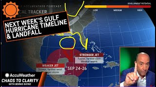
- ***Tropical Update...Invest 97L Forms in the Western Caribbean, could this storm become a hurricane in the northwest Caribbean, and strengthen to a major hurricane in the central & eastern Gulf? Full details on where this storm is going, where it is likely to make landfall along the Gulf Coast region, along with rainfall impacts from Jamaica, Cayman Islands, Central America, all the way to the Gulf Coast States!
***Cape Verde Season to Ramp up big time after September 28th???
***Western Pacific full typhoon outlook along with monsoon rainfall totals!
***Your Weather Forecast for much of Eastern North America as a much wetter pattern sets up! Full Weather Update in this edition of MeteoMark Weather!
Next 7 to 10 days potential for
Tropical Storm Helene
Tropical Storm Isaac
Atlantic Hurricane Season 2024 Outlook Watch here... • Hurricane Season 2024 ...
***Tip Jar...Buy me a Coffee... paypal.me/Mete...
***Or Send Me A SuperThanks button right below video! Thank You!
New Affiliate:
Trilogy Maps at TrilogyMaps.com & Don't forget to use the code " meteomark " at checkout for 20% off your entire order!!
Video Contents & Chapters:
0:03 - Intro to Tropical Update, Caribbean & Gulf Hurricane?
0:26 - Invest 97L Satellite View Caribbean & Gulf of Mexico
1:08 - Tropical Update of the Atlantic Basin - Euro Model Analysis
3:22 - Tropical Update for the Atlantic Basin - GFS Model Analysis
6:11 - Sea Surface Temperature Anomalies Outlook for Atlantic
6:30 - Tropics Dry Air & Moisture Outlook Thanks to TropicalTidbits
8:46 - Wind Shear Analysis for the Atlantic, Caribbean & Gulf of Mexico
10:54 - Rest of the Tropical Atlantic through Early October 2024
14:42 - Tropical Rainfall Totals Forecast through Early October 2024
17:00 - Future Radar Sep 22-24, 2024 - HRRR Future Radar
18:18 - Synoptic Scale Forecast Through Late September 2024
20:06 - Canadian Weather Outlook through Late September 2024
22:24 - Western Pacific Typhoon & Tropical Outlook Update
25:00 - Trilogy Maps Affiliate Information!! - Check Out Awesome maps!
25:57 - Temperature Forecast Sep 23-28, 2024
26:55 - Extended Forecast for Binghamton, NY To Scranton, PA
27:22 - Finale, Please Share, Like, Subscribe to MeteoMark Social Media!
Affiliate Disclaimer & Disclosure:
***Disclaimer: This video contains an affiliate link. If you click it, and make a purchase using my code included next to the link, I’ll receive a commission. Digital Custom Maps provided my new affiliate TrilogyMaps.com, Use Code “ meteomark ” & Receive 20% off your total purchase. I use these maps on a regular basis, and I must say I truly must say they are the best maps I have ever used. Using them with Photoshop is a breeze, and loading times were amazing. The layering system is top notch. Check them out at the link in the description TrilogyMaps.com and use my discount code “ MeteoMark ”. Thank you everyone!
MeteoMark Disclaimer:
MeteoMark has an Atmospheric Science (Meteorology) Degree from the State University of New York @ Oswego, years 2001 to 2006, Graduated December 2006. MeteoMark is a Full member of the American Meteorological Society since 2005. MeteoMark Weather is a Weather Agency Devoted to providing you with a look at the weather through A Meteorologist with a different perspective. MeteoMark Has been in Operation Since 2011. Although I am not an official source, I am a trained meteorologist with a degree in Atmospheric Science.
special thanks to metgraphics for lower third bar template, & forecast Icons
metgraphics.net
Model Maps & Data by A Commercial Subscription to PivotalWeather.com
Additional Model Maps (3D Maps) Provided by Radar Omega Alpha Edition
Music Provided at Beginning & Ending of Video by:
Music track: Talk by Chill Pulse
Source: freetouse.com/...
Free Music Without Copyright (Safe)
Twitter Icon Thanks To
commons.wikime...
upload.wikimed...
David Ferreira, CC BY-SA 3.0 creativecommon...,
via Wikimedia Commons
;creativecommon..., via Wikimedia Commons"
UA-cam Icon Thanks to
commons.wikime...
upload.wikimed...
ZyMOS, CC0, via Wikimedia Commons
Facebook Icon Thanks to
commons.wikime...
User:ZyMOS, Public domain, via Wikimedia Commons


***Greetings & Welcome Everyone to the Channel! Please Smash that Like Button if you loved this video, It really helps!!, Subscribe, Question or Comment & Share the Video with All your friends & Family. Buy me a Coffee by hitting that Super Thanks button below the video & I have a Coffee Link in the description as well. Thanks everyone, your support is greatly appreciated!
***Tropics About to Explode in August?..Don't forget to Watch My Hurricane Season 2024 Outlook Forecast Watch my full Analysis here...ua-cam.com/video/wqnTDK_oX2I/v-deo.html
***Great Stellar Maps Are Available through My Affiliate here...Trilogy Maps at TrilogyMaps.com & Don't forget to use the code " meteomark " at checkout for 20% off your entire order!
Hi Mark, we are here in the Florida panhandle watching closely, thank you for being here for us all.
Navarre florida here
Hello there, I will keep you updated on this storm, concerned about your area in he Florida Panhandle. It’s great to have you on the channel and I am always happy to keep you updated. Thanks for watching.
You Are The Best....... I trust your reports. I went to a picnic/ BBQ this weekend. We were talking about the weather I passed your name around. I told them what I think about winter and most of them agreed with me. Thanks for all you do.
Thank you so much, I truly appreciate it. It really helps get the word out. It was a beautiful weekend for a picnic/ BBQ. This weather truly is a gift so far. Thanks once again, and I look forward to providing you with many great weather updates to come.
What would be the potential impacts for Georgia? Any chance for TS Force winds in Central Georgia? What about tornadoes, and flooding? Thanks for the update.
Great question, I think there is a very good shot at Tropical Storm force winds well into Central Georgia. In addition to rainfall at least 5 to 10 inches with locally higher amounts, the wind will definitely be a problem well north into Central Georgia, especially if landfall is right down the center of guidance toward the Florida Panhandle or Big Bend Florida area. I will be watching this very closely for you, as I think this storm would still be quite an inland buzz saw so to speak with wind. I will keep you posted, thanks for watching and it's always great to have you on the channel.
Always look forward to your reports, Mark ⭐️
Thank you, always happy to get a good Sunday evening weather update out, happy to provide.
Here comes the hellyon
Looks concerning, watching from nyc here
Watching very closely as millions will likely be impacted. Storm size is of great concern.
Watching from Wakulla. Seems to have the same path as Michael so far... praying it's not as strong 🙏 Stay safe everyone 💕
It is definitely concerning, as I was tracking this storm today, it looked eerily familiar to Hurricane Michael track. I will keep you updated on this storm for Wakulla, as so far the track is taking it in your general direction. Praying too that this ends up being weaker than model guidance and trends. Stay safe, and thanks for watching. It's great to have you on the channel and I will keep the updates coming ahead of this storm.
Good night mark big up stay blessed 🙏😊
Good night, thank you so much, stay blessed as well, and stay safe. I will watch this storm and upcoming tropical waves closely for you in Jamaica. Lots of rain coming your way.
@@Meteomark yes bro loving this rain for sure have a great Sunday ❤
Your thoughts on a more Western track? South Mississippi here…
Great question, I think we still need to look for that possibility of a further western track if that trough over the east slows down and stalls further west and draws it up closer to Mississippi, Eastern Louisiana & Alabama. Right now the models are more progressive on the trough, drawing the storm closer to the Florida Panhandle, but just a small shift in that trough and slowing down the trough would mean a further west solution. I definitely can't take that possibility off the table just yet being nearly 5 to 6 days out. I will be watching this very closely for you in South Mississippi, thank you for watching and it is great to have you on the channel. I will keep you posted.
@@Meteomark thanks a million!!
If y'all know it's going to Florida why your thumbnail don't show just Florida
Many will be impacted outside of Florida too, due to the shear size of the storm. Plus a storm this size could wobble a bit even within that 5 to 6 day window. Millions will likely feel the impacts of this storm. Keeping close watch as yes Florida is still looking like landfall point but very large circulation.
Nw florda here in navarre
Watching this storm very closely for you for NW Florida Navarre area. I will keep the updates coming this week for you, and it’s great to have you on the channel.
What impacts could Miami-Dade feel since it appears to be East side loaded?
Great question, for Miami-Dade area, I think those eastern feeder bands will likely lead to flash flooding and flood concerns, along with gusty winds potentially up to tropical storm force wind. Even after the storm makes landfall, there will likely be a tropical connection fetch continuing across South Florida, particularly the Miami-Dade region. A landfall as far north as the Florida Panhandle, could still bring those eastern feeder bands into your area, due to the shear size of this unusually large circulation. I will be watching this very closely for you and will keep you posted. Thank you for watching and it's always great to have you on the channel.
@@Meteomark okay thank you so at minimum we will probably be under a Tropical Storm watch or Warning?
@hi is hurricane isaac will not hit georgia?
Hi, If this storm does hit Florida Panhandle to Big Bend region which seems to be the most likely solution so far, it is possible this storm could make it as far inland as the Florida Georgia border and still retain hurricane status. It will quickly weaken to tropical storm status, but could very well spread tropical storm force wind well into Central Georgia. Watching this one closely for Georgia, I will keep you posted. Thanks for watching and it's great to have you on the channel.
@@Meteomark not in southeast Georgia Right?
Jamaica will get gusty wind?
Jamaica should get some gusty wind, but sustained wind will be below tropical storm strength. Jamaica could see a few gusts at tropical storm strength but the big thing will be the bands of heavy rain 🌧️ on the east side of Invest 97L. I will keep you posted.
Yes mate do more videos
I will definitely do more videos, frequent updates coming especially this week.
I live in homosassa Florida what’s going to happen here
Ok then
Looks like Hurricane Michael
The euro is always weaker solution
You are right on that, I don’t think I have ever see the Euro stronger in any scenario than the GFS on any particular storm.
@@Meteomark yes sir I agree