Scotese Animation: Paleogeography (750 Ma - Present-day)

Вставка
- Опубліковано 4 жов 2024
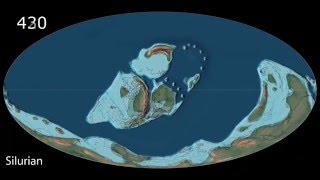
- This animation produced by C.R. Scotese, PALEOMAP Project shows the changing distribution of deep ocean(blue), shallow seas (light blue), land (tan) & mountains (brown) during the last 750 million years. Please cite as: Scotese, C.R., 2014. Animation: Paleogeography (750Ma - Present-day), PALEOMAP Project, Evanston, IL. • Scotese Animation: Pal...
The animation was produced in 1998.
For more info about research work and publications of C.R. Scotese and the PALEOMAP Project see: www.researchga...
music: Pachabelly by Huma-Huma


![[4k]Sea Level Rise and Fall Simulation - World](http://i.ytimg.com/vi/q87mUl13s-s/mqdefault.jpg)


Thanks for this, and for the Paleomap Project. Each year I give it to my biogeography students. Happy New Year to Christopher Scotese, a scientist who has helped to train the whole world in multiple disciplines, and his team.
+Dan J Thanks so much! Best Wishes in the New Year to you.
@@cscoteseyou forgot cyrogenian and edicaran
Thank you for your kind comments!
+Christopher Scotese Although visually it makes sense when just looking at the land mass but when taking in the size of the earth not changing when we know for a fact that earth gets heavier in billions of tons per year from outer space debris was not taken into the thought. Now remove the weight each year and speed up the reversal if you were Dr. Who and you would see the earth shrinking.
Not taking into account the earths mass being removed when going back in time is stupid and retarded. create pangea on a super sized uninflated balloon then now blow it up and now you have an idea of plate tectonic. earths weight/volume NEEDS to be taken into account and only a few want to do that.
Not accounting earths weight into this shows the amature nature of so called plate tektonics.
+Inachu Ikimasho The Earth looses mass from gases lost to space in the upper atmosphere (H, He, especially) and from materials ejected into space by volcanic eruptions (Earth rocks have been found on Mars). So the amount of mass gained from meteorites and comets is negligible, especially when compared to the mass of the Earth ( ~ 6 billion, billion, million kilograms!!)
+Inachu Ikimasho
"so called plate tektonics"
ROFLMAO
does anyone take you seriously? I rather doubt it.
+Christopher Scotese I don't think terrestrial volcanos would have sufficiently powerful enough eruptions to launch rocks into space. Asteroid impacts would definitely account for such energetic incidents.
I LOVE the animation -- and have a request... can you spin the map to stay somewhat over the general center of mass for the time preceeding the triassic, especially the silurian-> ordovician? please???
+Christopher Scotese i was hoping sea level change would be visualized too. not due to tecnonics but due tu ice ages coming and going etc...
I assigned your video for students in my ichthyology class so that we can talk about drifting lands and drifting fishes. Thank you very much, Chris, for your consistently excellent work. Willy
Your very welcome! I am glad my work is useful to you and your students. - Chris
Let's go back in time.
A Chinese poet wrote these words 1000 years ago, "I repine at the shortness of my life, and envy the great Yangtse River its eternal course. " 哀吾生之须臾,羡长江之无穷。
These animations are amazing. As a newcomer to all if this, I find this fascinating. Don't remember learning about any of this at school, or maybe it hadn't even been discovered back then
Спасибо! Это большой труд. Теперь можно и в обратном порядке запустить.. Из прошлого в современность.
The best of your creations, Chris. All those microplates finally measuring up. Now, please make them move about as they did in reality
This is the most beautiful video ever uploaded to YT
Philipp J I know right
I love that you started from today and went back in time! Makes it much more interesting and the music underlines how impressive mother nature is
Meu Caro, isto é simplesmente espetacular, extraordinário!
These are terrific! One of my fave resources ❤
Beautiful video. For us, 750 million years ago felt like just 15 years ago as of 27th September 2024. It's like ancient history feels so recent. By the way, what's the name of the classical music? It's heartwarming.
This man keep rearranging landmasses all the time that now I have trouble just to go to work.
Today 0ma - 0:10
Eocene 50ma - 0:35
Middle Cretaceous 80ma - 0:55
Early Cretaceous 120ma - 1:10
Late Jurrasic 140ma - 1:15
Early Jurrasic 160ma - 1:20
Late Triassic 200ma - 1:30
Middle Triassic 220ma - 1:35
Early Triassic 240ma - 1:40
Late Permian 260ma - 1:45
Early Permian 300ma - 1:55
Carboniferous Period 340ma - 2:05
Devonian Period 400ma - 2:20
Late Silurian 420ma - 2:30
Early Silurian 440ma - 2:35
Late Ordovician 480ma - 2:40
Middle Ordovician 480ma - 2:45
Early Ordovician 500ma - 2:50
Cambrian Period 540ma - 3:00
Late Precambrian 560ma - 3:05
Middle Precambrian 600ma - 3:10
Middle Early Precambrian 660ma - 3:20
Early Precambrian 750ma - 3:35
skeemag jr no it was 4.6bya
560mya-1bya was neoproterozoic
3:35 was actually late Precambrian
This is sad with the music, kind of scary. Love your work!
Alex Xela and time reversed
Late but the music is “pachabelly”
Thank you for this
Plate tectonics as the beautiful process it is!
Can we really extrapolate back that far? You can plainly see how the land masses seem to fit together but has geology precisely measured the velocity and vector of each of these plates? There must be biological markers correlating and connecting these places as well. Its really quite interesting and these are honest questions. I like how this model makes predictions but I'd like to know the parameters used for it?
Awesome continental drift 750ma
Any way that we can view this in "reverse"? I would like to see it beginning at 750 MYA & moving to the present. Just makes more sense to me that way!
I will do it!
I could do it, too.
@GlobalistsR Traitors is saying Types reply backwards.
As beautiful and fascinating, informative and scientific this animation is, I also find it deeply unsettling- it is literally turning my world upside down to know (more specifically than before) that oceans shifted and continents floated around so much in the last half-billion years.
Why not render on an actual oblate ellipsoid?
Большое спасибо вам! Мы это знали, но так наглядно, с указанием периодов.. Это отличная находка. А может быть и размеры нашего шара менялись? А может, это подскажет, почему находят одинаковые окаменелости древних животных в Мексике и Африке. Мы продолжаем дрейфовать и через миллион лет будет совсем другая карта планеты. Респект из России.
Music is kinda lovely 🌹
the blue part at the lands is shallow seas between 0-200 metres in depth
I Love this music
Gotta love those orogenous zones. They result in the creation of new...land. ;)
This is so cool! I also have to mention that I've seen your maps since the very beginning of my studies. Many academics just love to show them to us :)
Thank you, truly amazing!
So Madagascar was attached to India?! neat
Fascinating! :)
I'm sure this constituted a very significant amount of work, for which I and I am sure many others thank you. The projection makes it quite difficult to visualize as the continents move poleward and then splay laterally. Is there an animation tool that would allow you to, for example, use a spinning globe as the framework for this so that there would be visual continuity across the East-West discontinuity that results from this projection? A spin every thousand years with the locations changing would be a fantastic reference.
This is true Hawaii looked different but in the maps it changed
Awesome animation btw, just had to see the entire thing
This is an amazing animation!
You should create a direct download link for a high quality version of this video and post the link in this video's description area.
Beautiful.
OMG! My students need to see this! i will show this in the geological Earth's changes. Thank you so much!! is a lovely animation!
Sorry for the bad english, isn't my native language.
Amazing work
Isso me fascina
🌏🌍🌎🙏🎇🌿🕊️
Excelente.
Exquisite!
0:01 Today
0:19 Neogene
0:43 Paleogene
0:49 Cretaceous
1:19 Jurassic
1:39 Triassic
1:41 Permian
1:53 Carboniferous
2:08 Devonian
2:25 Silurian
2:39 Ordovician
2:55 Cambrian
NEW YEARS AGO
3:06 Ediacaran
3:15 Cryogenian
3:33 Tonian
Very Groovy.
The music sounds kinda like a slowed down Canon in D Major. Which makes sense since it's a wedding song for the continents.
I love this song
I wonder if you can do this on Adobe Animate 2020.
@Pedro Lucas Pereira Silva no i mean if i can do this on adobe animate i meant you as in everyone (sorry english is kind of weird)
Are there any postulated factors that explain India’s rapid movement northward? I understand that a mantle plume is the driving force, but why is it so very different than any other of the crustal plates in motion at that time?
By the way, cool map!
I've been meaning to ask you about how you tween the individual pictures to make the continents move. I've been trying to do the same but to no avail. I tried to do it on flash, but I'm probably doing something wrong. Any help would be appreciated. :-)
This particular animation is made from ~50 key frames that were generated by a computer mapping program I wrote. I then "morphed" between key frames using the program "Morph". Each morph had 100-200 control points. I hope this is helpful.
Man, how did you do Pangea Proxima to 300 million years into the future?
I'm at a time when you are so much for a few weeks and months and it will take the bus driver just got to go
Algol? I can totally tell why you are here at a Christopher Scotese video, you also do continental drift.
Hi
Hello, Christopher. This film is fascinating, and beautiful. Is it to much work to reverse it, and let it play with normal time direction? From 750 mya towards present?
I think I'm right in saying the southeast of Australia was pushed above sea level via the Pacific plate's pressure on the south island of New Zealand. Up until that point wasn't it underwater?
в earth viewer континенты точно такие. есть paleo и ancient
1:49
Bro is from pangea to rodinia
Nice job on the animation ! Too bad we can't get Saturday morning cartoons to slip a couple of these in once in a while, maybe we would end up with a few more scientists here in the states. I'm looking for the source of a graph "global temperature and atmospheric CO2 over geologic time" because all the scientists I trust say "this is the best data we have." Where can I find information on that ? Thanks and Merry Christmas ! Rick
please tell us the name of the music used in the video.......thank for sharing this video.
Pachabelly by Huma-Huma
Can you make plate tectonics 750MYA to now
I want to work on this all my life like you
then - first learn about fossils, then geology, then computer programming, then stratigraphy, then paleontology (vertebrate & invertebrate), paleoecology, then plate tectonics, then paleomagnetism, then basin evolution, then meteorology, then paleoclimatology, then paleoceanography, then some geophysics, then radiometric age dating, then some geochemistry, then GIS, then climate modelling! Prof. Scotese
yes, I'm studying geology and I'm going to finish in 2017. I'd like to work in this area but in Argentina there isn't any project like PALEOMAP
I would be awesome if you put this animation on Google Earth.
Any guidance as to how that might be done would be appreciated. -C R Scotese
I only know how to use the program. I'm sure if you contacted Google they could help you out. Or you could ask a prof. in a computer science program at your university.Interdisciplinary collaboration between two faculties would be pretty interesting and rewarding.
+Chris Duncan But it's not accurate.
It's WAY better than nothing
Dr. Scotese, I'm not sure if this has been answered yet but you can overlay polygons/shapefiles into Google Earth and associate each frame with a timespan element. Not sure if you can integrate your key frames but if they're transformed into shapefiles it might be possible. developers.google.com/kml/documentation/time
Do you happen to have these animated as mapped onto a traditional globe?
Raul A. Gutierrez check out some of the Earth from space animations at: ua-cam.com/users/cscotese
Thanks! We're trying to create a best guess animation of the earth from formation to now. It's surprisingly difficult to find good references!
I find it hard to believe that these plates could migrate _against_ the *centrifugal force* of the earth's rotation observing that it causes 27 mile high bulges at her equator. Or being at speed would plates only'feel' acceleration? Like a person in a car?
Music so cute
2:15 Cómo que la Antártida creció? No?
I didn't know my home country didn't exist in pangea Philippines
Why is everything jiggly
I saw it on PBS eons channel
I love your animations...but it doesn't make much sense to me that in this one, from the 500m to 750m range, the land features are positioned on the edges of the animation and the vast featureless ocean gets center stage.
It makes sense to me in that it's telling me that the land features are opposite to where humans normally centre the map - over the Americas and Europe, ie the Atlantic. This tells me this area was ocean and the land features were surrounding. No doubt flipping the centre of the animation at some point would be interesting, too, but but more complicated.
i like it that fish is gone already
WOW....
Hi Chris, I don't get it. Isn't it from present day to 750 Ma ?
Is the music from a Brian Eno piece?
Pachabelly by Huma-Huma
I'm a Great Lakes girl and I know you're using them as a landmark for North America, but they really should disappear from the display at about 12, 000 y.a.
Hi, just wondering how I can contact you ? As I would like to use this video in an educational exhibit at an nonprofit.
I still don't understand how India moved so quickly north without a corresponding movement of antartica south.
It's because the Indian plate was also being subducted under the Eurasian plate, which basically pulled the rest of the Indian plate faster towards Eurasia. And Antarctica was also almost surrounded by divergent boundaries, so there wasn't really much to go to as well.
i found number that kids would call the fun E number
I watched this in science :P
What about the expanding planets theory?
What about it? There's no evidence to support it all. It's not even a theory, it's a hypothesis. "Continents seem to fit like puzzle peices? Huh, I guess earth must've been smaller for them to all be close enough to fit". While moving tectonic plates actually has a massive amount of evidence and is actually observable now that we have GPS and have to account for continents moving the tiny centimeters that they do every year.
It doesn't make sense visually. At 1:34 you would see Europe merge into the rest of the land formation by going straight East. It was one big continent.
+DarkByke Twitch watch the other videos that this has nothing to do with moving plates at all. We all know the earth is gaining billions of tons of weight each year. Now reverse that trend for the past many millions of years and you would see the earth shrink. In effect the earth is like a balloon and nobody does the so called math for the weight increases.
Inachu Ikimasho
Yes, this video shows tectonic plates shifting.
WOW
Is Iran up or down?
Cool Video! But Sad Music :)
Expanding Earth Theory, read on it. Makes more sense than this antiquated and flawed theory.
+J G I totally agree with that video!
+J G
"makes sense"
and
"has evidence for"
are two entirely different things.
plate techtonics literally has generations worth of evidence in support, and nothing to reject it.
It's like people saying "creationism makes sense". It's irrelevant what "sense" it makes. to you, or to anyone else, if it has no real evidence in support.
+Thomas Neal I'm near certain that the Earth is actually shrinking over the last decade or so. Either that or else I'm expanding.
Expanding Earth? Show some evidence of significant expansion. Aside from a possible net accumulation of solid material (space dust?) close to being offset by loss of helium from radioactive decay of thorium and uranium, as helium rises through rock (it really does!) and escapes the Earth's gravitation...an expanding Earth would imply a general increase in surface area of water as seas get shallower. As one sea expands, another must shrink (the Atlantic Ocean is expanding as North America and South America head west into the Pacific Ocean and Africa drifts toward the Indian Ocean.
Scotese's map of 750 million years ago suggests that western North America had recently split from Australia and Antarctica, suggesting that continents that look to have been very close to each other have separated by nearly half the circumference of the Earth. On the other side, what is now the southeastern United States (Florida is obvious enough) was separated widely from North America and even had France, England, and northern Germany attached in between it and a long sea distance to lands now a short distance from the American coastal Southeast.
It takes me almost twice as long to bicycle some place as it did 20 years ago. Some places are getting further apart.
Music? Please
That’s sad music
How is the lyrics
I've heard of this continent before:
*Ur*
Yeah the name is so weird.
Pbs eons sent me
THis is for the creationists !
:( sad song guys
But o want in reverse instead the starting
What formed the Antarctic Peninsula? The video makes it look like S America ripped it out.
The Western (Palmer) Antarctic peninsula is mostly made of volcanic rocks that go back to the Triassic. It was originally a continuation of the Andean mountain chain. It was torn away from South America when the Weddell Sea opened ~180 million years ago.
Thank you sir
What the music?
Pachabelly by Huma-Huma
Сибирь=)
Whats the score/music playing called?
+Gagara Dunibres
sounds like Pachelbel's Cannon to me.
+Thomas Neal Do you happen to know which version? There are so many covers of that song.
lol they always show pangea as being on one side of the eath!!! That never happened!
It theory! They just try figure out what happens in past! Oh ya, it's recent go to pass! Not future!
1:45 deurkshtuer
😂😂😂😂😂😂😂😂😂😂😂😂😂😂😂😂😂😂😂😂😂😂😂
0:11 0:12
0:13 0:14
0:15 0:16 0:17 0:18 0:19 0:20
0:21 0:22 0:23 0:24 0:25 0:26 0:27 0:28 0:29 0:30
🤣
So the other side of the globe was blank? Lol
Makes more sence if the globe was shrinking with it .
Volgen West the only way this could work on a globe would be if it was shrinking
This map is way off! How do you have most of Africa covered in mountains today, while the highest mountains during earlier stages are just a tiny sliver? Inaccurate map, and total disinformation.
The reddish brown area represents areas >1000m - not necessarily mountains. Africa is anomalously high, probably because it was at the center of PAngea and the crust was thicker at the center / or because the mantle below Africa is hotter.
More evidence for expanding Earth. See the UA-cam video on that.
Because nothing says "my scientific idea is valid" more than a UA-cam video made by someone who has no idea of physics. Forget writing and submitting a scientific paper to other scientists - just make a UA-cam video and let idiots do the rest. 🤡