Plate tectonics, Paleogeography, & Ice Ages (dual hemispheres)

Вставка
- Опубліковано 29 лис 2019
- Scotese's newest animation. More Info to come soon.
Music: Canon in D Major by Kevin MacLeod is licensed under a Creative Commons Attribution license (creativecommons.org/licenses/...)
Source: incompetech.com/music/royalty-...
Artist: incompetech.com/
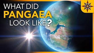


I really like this one because it avoids distortion around the poles from the map projection in other animations like this.
I’ve actually always wanted to see one of these with a polar view.
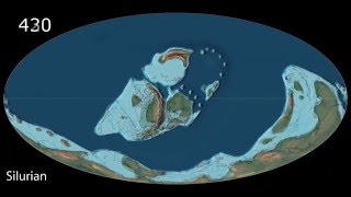
C~150mya:
European/African continents: "bye then"
American continents: "we're keeping the velociraptors"
And then they started fighting for custody over Britain.
Ruth up
Unfortunately for them, the court decided both continents were unfit and awarded custody to Asia instead.
North America
I would love to see this animation, based on current plate movements, projected 500 000 or 1 million years in the future.
There are other UA-cam videos that do just that.
Nothing really happens in a million years in plate tectonics.
Yeah some continents may move a kilometre or two, or existing rifts may deepen and what not. The fastest plates only go a few cm per year, in a million years that's only 10-20 km. There a few interesting spots, like the closing of the Strait of Gibraltar which will wreck havoc in the Mediterranean, causing a new Salinity Crisis. Or the closing of the Red Sea. But on a global scale it doesn't really matter if the Atlantic is 10 km's wider or Australia has move 15 km's to the north(apart form becoming even hotter).
It's in the tens of millions of years that really interesting things start to happen, like a new mountain range like the Himalayas where the Mediterranean Sea is now, due to Africa moving north. The split of North and South America. Australia & Guinea ramming into the Philipines or the break-off of the eastern part of Russia to melt with Alaska.
This will make being in the real estate business, very interesting.
Only the first hundred could possibly matter. Consider the moon , one crater at a time , central peak , near vertical rim , dust an rock powder , stone immaculate , ice music , taco bell Cannon..there are jazz and more rock a
n roll versions of this song , maybe in a ska style but in a waltz time..
He has another video of it. So does Algol
Coooooolll !!!!! Crazy, The actual ice age is like a blink of an eye in the hisrory of earth!!!
Oh, it's a lot more crazy than that. There have been no less than 5 Ice Age cycles where ice has peaked and dropped to nearly nothing and back again... in the last 500,000 years.
It's called the Pleistocene Era. (And the tiny fragment of our own Holocene Era).
@@tananari47
Did science tell you this or did you just come up with a theory on your own?
The truth is very shocking but at some point you may learn the truth and science are the one's that hides it.
Be very careful with those who give you information and later changes it because they were publicly wrong !
There's much more to the historical story that you are kept from know , it is hidden on purpose.
Seek and you shall find , once you find you shall be amazed.
He that finds will not taste death !
We are living in the age of disclosure , nothing hidden stays covered .
@@NOTTHASAME I don't take advice from people with worse grammar than my ten year old niece, thank you.
even the existence of humans
@@NOTTHASAME What people like you need to understand, is that science is working as intended when corrections are made. You need to stop looking at science as a fixed model. Science evolves as our understanding and capabilities evolve. Being critical of information you view is a good thing, but disregarding it because you think they lied to you the first time, is just wrong. Science is an evolving conglomeration of our best known theories. We are still explorers.
WoW! Great work! Just love the double hemispherical view and the period ruler. The details of land masses and ice caps are amazing!
I see that Mr. Scotese have an accurate Musical preference.
Perhaps it would be only a flash on the screen, but it'd be interesting to include the Messinian Salinity Crisis when the Med was a 3-kilometer deep desert.
Good point. In fact there were repeated episodes of drying and flooding, propably related to sea level
changes due to ice age cycles, besides the geological blocking of the Gibraltar entryway.
@@vasilisiatropoulos3474 Or perhaps intermittent blockage at Gibraltar. But actually this was about 3 million years before the Ice Age officially got started, at least by the definition that includes glaciation at both polar regions. Antarctica had been frozen for something like 30 million years, if I understand the data properly.
With all that geological mystery going on near Gibraltar, one might think Atlantis might have been involved, if it existed.
@@RodMartinJr From what I understand, the Messinian Salinity Crisis lasted from about
7 to 5 mya. Some marshlands & large lakes persisted though in the deeper areas, thanks to river flows (some speak of an impressive waterfall at the mouth of the Nile !), throughout that period and that is the source of significant hydrocarbon deposits today. There's compeling evidence that there are also Jurrasic deposits from the long gone Tethys sea even deeper .However, the Med is destined to disappear in a few tens of millions of years, and give way to a large mountain range similar to the Himalayas as Africa will eventualy collide with Eurasia. It's a fascinating story in all.
@@vasilisiatropoulos3474 yes it is a fascinating story. Kenneth Hsü's original thesis had the earlier date, but the latest figures I've seen peg it at between 5.9 and 5.33 Mya -- right at the end of the Miocene Epoch, during the Messinian stage or age.
There is some evidence that as the northeast corner of the Africa plate collided with Eurasia some 40-50 Mya, the event triggered temporary stoppage at the triple junction at the MAR. This may have resulted in folded crust at the new crust east of the MAR -- enough of an impediment so that subduction was blocked locally, though it continued all along the Africa-Eurasia boundary, except where it had collided with what is now Persia. This resulted in the Africa losing part of its mass, giving birth to the Arabia plate, and starting the shearing which continues even today as the Rift Valley and the as yet incomplete formation of the Somalia sub-plate.
With a persisting impediment to subduction, the Africa plate boundary became increasingly folded, as evidenced by the jumbled nature of the ocean floor in the region, today. But back then, as the folding continued, the northward thrust of the Africa was converted, locally, into an upward thrust, forming an island. This plate boundary damage continued until the upward growth could no longer be sustained. This effectively stopped the northward movement of the Africa plate, locally, while subduction continued along most of the Africa-Eurasia plate boundary. This west-side impediment resulted in the Africa shifting its Euler pole of rotation with respect to the Eurasia to near where it is today, about 1,600 km SSE of Terceira Island. About 35 Mya, this rotation began, as evidenced by the sudden bend in the Africa-Eurasia boundary at the eastern edge of the Azores underwater plateau. The young spreading center (ridge) from that bend and up to the MAR also support this thesis. Plate fractures across the Sahara date to the same period as the Africa underwent the stresses of the change in plate movement.
Like a paper jam in a printer or fax machine, damaged plate boundary next to continuing subduction forced the creep of boundary damage eastward, enlarging the island. After about 30 million years, the folded crust reached Gibraltar, blocking the entrance to the relatively new Mediterranean. I discuss some of these details in my book, *_Proof of Atlantis?_* including evidence from 3 different scientific disciplines that correspond to Plato's date for the demise of that island
@@RodMartinJr Thank you for taking the time to elaborate on this issue.
6:10 I like the green dot in the Atlantic nice touch.
The Azores were a lot higher, look up isolastic land movement as weights are redistributed across the globe.
Stephen Harrison the Azores are the mountain peaks of what was once a large series of islands maybe even a small continent.
Setting it to Canon in D was brilliant. Great video!
This is your best work yet. Makes so many things clear.
Every just look out at the horizon and think about how massive and ancient this thing is
Rigel Hold
Regulus My
Betelgeuse BEER
@@QuizmasterLaw Not sure what this was trying to say as while vastly more massive due to stellar lifetimes being extremely inversely proportional to mass. If this was a counter argument then it holds just fine but if not as I pretty much must assume in the internet era,
hyperphysics.phy-astr.gsu.edu/hbase/Astro/startime.html
Rigel and Betelgeuse only formed somewhere within the last 10 million years though since stars of their absurd masses burn through their fuel only a few million years after they formed.
Super giant stars such as these are the final phase before supernovae within stars that were formed with about 20 solar masses stars like this pulse back and forth between red and blue supergiant stars until there cores few up to iron undergoing runaway gravitational collapse counterbalanced only by neutron degeneracy pressure and rebounding as a massive extremely luminous shock wave called a supernovae. Yeah indeed they are massive but anything but ancient. ;)
What really blows my mind is that Earth is about 4.5 billion years old, while the universe is a little under 14 billion years old. The age of the Earth is a significant fraction of the age of the universe. Not to mention that life has been going on here for a few billion years, and it keeps getting pushed back earlier and earlier as we discover more. Hard to even comprehend on human timescales.
Brilliant! Thank you for this - so many fine details that merit notice - this will be a must-watch repeatedly.
Love your animations. Thank you Mr. Scotese.
Thank you, Sir! I love your visualisations!
I like paleogeographic animations like this: smooth. This is how plate tectonics actually move, not frame by frame.
My God, my Master will absolutely burst out of crying when I deliver this on my presentation, thanks so much Sir
I don't how many years I've been looking for a video depicting this but I am glad It has finally been made here for all to see.
maybe a creator commentary video going along the timeline and expressing the degree of certainty would be a nice touch but marvelous work regardless!
(edit) or I could just watch all the other videos on your channel.
wow, just wow. I just realised that the mountains not only appeared but disappeared too. I now wonder if the Himalayas are the tallest mountain that ever was.
Nikolay Andreev they're still growing so possibly.
No way to know, but quite possibly. The northward march of India was probably one of the fastest tectonic processes in geological history. By comparison, every other "collision" of plates was just a sort of slow oozing together. What is unique about the Himalayan orogeny is not really the height of the mountain chain, but the enormous Tibetan plateau beyond it.
as others have already pointed out, it's hard to tell if the Himalayas are the highest mountains to have existed but you may be unaware of the subsidence effects currently happening. as the crust crumples, the rock doesn't only rise but it "falls" as well, sending massive mountain roots into the magma region. the southeast region of the Himalayas is already subsiding as the roots there are eroded by the magma and are no longer able to support the weight. Death Valley (in the US) is a good example of where this effect has already happened.
I think the Trans-Hudson Orogeny in the Canadian Shield was considered to be higher than the Himalayas. And 100 million years from now, the ongoing collision between Europe and Africa will probably turn central Europe into a mountain belt higher than the Himalayas.
Yeah I learned in geography that Canada’s mountains were like double the size of Everest, but they eroded down and the leftover rock from it slid into the ocean and created other parts of Canada and US
I wish I could find what time period that was in the vid but Idk
Very beautiful and clear presentation thank you very much Sir!
Your vids are so satisfying to watch!
How wonderful. thank you for such great work.
One of my guilty pleasure,,watching our living jewel of a planet wax and wane and listening to classical music!!!!!
Thank you, your animations are incredibly useful.
I've been a map fanatic for the last 60 years. Love this stuff. I just wish we could see this in Mercator projection or similar. Some of the detail is missing or difficult to see in this type of projection. For example, the large landmass in the right hemisphere disappears at the terminator, and we don't see the other edge of it in the left hemisphere. Sure, a flat projection distorts things, but it allows us to see more of the detail.
No ok boomers here
@@Versuffe Why? Who created this channel?
@@nunofoo8620 Okay, thanks.
I'm trying to think of a funny joke about "projecting your insecurities". I cant think of anything. Just imagine this comment is something hilarious about "projecting your insecurities".
no Antarctica 👀
Chris, this just keeps gettjjng better. The modelling of SE Asia is now more realistic, showing the remarkable complexity and orogenic evolution of once massive mountain chains. What is often not realized is that while the surface of the earth evolved over time so did both the internal structure and chemistry. The additon of ice is great. Thanks.
Anthony pain's video are great.
nice. as this sucker for plate tectonics, maps, and continental drift found a favorites video, your channel found a sub.
This was really neat to watch. So much better then the models that show the current continents all ready established at an early stage. I prefer just having the outline of the area of the modern day continents. Very well done!
YES! It’s good to see your stuff again!
Vtron true
Thank you for the period ruler and the perspectives.
Não tem nada mais relaxante que assistir a dança das placas da Terra com o canon de Pechelbel como trilha sonora. Eu poderia ficar vendo para sempre...
Concordo com você
It always breaks my heart to see how amazing these videos are and how few views they have. (That like/dislike ratio is where it's at, though - 138:0, at time of writing. Dang.) This work is so well done and useful; the animation transitions so smoothly from phase to phase; I love the scrolling timeline; it's all so good. Fabulous work.
Teague Chrystie take a look at Algol YT channel
You get a thumbsup for the music and a comment because I really enjoyed your work. Thank you.
This is a huge project: the entire earth in half a billion years. Thanks Chris. I hope one day you get a bunch of grad students, each concentrating on just one of the continental pieces, and then you assemble the results. that way, this would be not only accurate in generalities, but also in specificities. For example, the entire history of the Urals is fudged over, while the Asian-European collession should be somewhat the center stage at some point, the creation of the Tethys. The opening and closing of the Gulf of Mexico, the
Eranic micro plates and gulfs, MacKenzie-Missouri sea, as well as the Mediterranean, leading to so much removal of salt from the earth's oceans to create a "Salt" crisis never mind the oil beds creations, and dozens of microplate moving about.... Remember, EVERYTIME you have huge salt deposits, that tells of the place having been a trap for the sea water, meaning it keep getting flooded, then evaporated, then flooded, then evaporated over and over again, leaving behind, miles deep salt deposits. So, just follow the salt foot print, and it tells you where the sea/salt traps were: Gulf of Mexico, Iran, Canada-Colorado, Baltics, Mediterranean, central Asia..... All the same, thank you for your time and the great film.
I have just been trying to understand when the Turgai strait started and your video shows that... ... Been searching for days... ... and same for my country Denmark, that has been under water most of the time... first time i saw it I had a big loss like we dont learn this in school... thought its always been there... like loosing a stable datum, or a very dear friend..... When i studied the last iceage.. and loss of dogger bank.. or land... thats one thing... but that its been under water for most of the last 500 mill years that was a shock...😊
Your projects are very usefull to many fields, i am always used it lecture to my geography classes.
great video! I love the music and animation!
Just subscribed. Your video's are facinating.
Wonderful video. Thank you for putting this out there. Very helpful model for showing my Freshmen science students.
Retired Geologist here. That was great! Thanks for posting.
Incredible work Christopher!
More great plate tectonic animations from the Master!
Fantastic graphics. Extremely good illustration of continental drift and it all started from Godwana land.
I grew up south of Seattle. We were pretty sure our 15 acres was at the edge of a glacier. The north end where we had our garden had rounded rocks and loose dirt. The southern third was all gravel. Even though my sister, brother and I picked out all the rocks before planting, there were more the next year! That's when my dad introduced me to the "stacking plate" theory. Just like dinner plates that rise to the top at a buffet, our rocks were doing the same thing. Take one out and another will take its place over the course of a year. At 8 years old, I did not find that amusing. Five cents a bucket didn't cut it. 😡
I recommend looking up granular segregation as that seems to be the effect you are describing
www.annualreviews.org/doi/full/10.1146/annurev-fluid-122316-045201
Basically in a system with granular particles of various sizes disturbances can enable smaller particles such as dirt and gravel to fall between larger particles such as rocks over time effectively pushing rocks upwards. Erosion and sedimentation help counteract this by producing new small particles but alas it is a never ending process. Also depending on where in Washington you were it may have been glacial dam burst floods instead being carried down the Snake and Columbia river systems and carving the scab lands.
I like this view because on some videos there is a "whole earth" view where the continents all cluster around the edges while I am looking at a big blue ocean.
Part 1
Hello Dr. Scotese, this was absolutely breathtaking to watch. Thank you!!! I found it far too important to not stop and comment on this subject. And more specifically, to allow me an opportunity to express an opinion as to the true and accurate description of the mechanism involved in plate tectonics.
It’s interesting when you consider how much the standard model is dependent on the mantle having a convection regime. The great Arthur Holmes is credited to its acceptance in geology and the suggestion it could be the missing energy source to drive the tectonic plates. But, he also readily admitted it could be wrong. To date there is no direct observable evidence of the mantle having an up welling of lower density material resembling a convective cell or even a conveyor belt type of mantle movement beneath the tectonic plates. The standard model is only speculative in these regards. But even more importantly, the surface observations over the years have continually presented evidence of a mechanism of plate movement far different than what convection could provide. The mantle appears instead to be a solid state material that is 2,900 km thick, with pressures so great that at only 100 to 250 kilometers carbon can be squeezed into a diamond matrix. There are now a growing number of researchers who are skeptical of the standard model’s over-dependence on such an overly simplistic idea.
Carlo Doglioni, the geophysicist and former president of the Italian Geological Society, and since April 2016, the president of the National Institute of Geophysics and Volcanology has published some very remarkable papers in regard to mantle dynamics and plate tectonics.
www.dst.uniro...antle_Dynamics_
MANTLE DYNAMICS AND PLATE KINEMATICS
Carlo Doglioni, La Sapienza University, Rome, Italy
Roberto Sabadini, University of Milan, Italy
". . . . . none of the proposed models of mantle convection can account for the simpler pattern in plate motion we observe at the surface, nor has a unique solution been proposed for how material in the mantle convects. At the moment there is no way to link mantle dynamics and plate kinematics at the surface, considering that the mantle and lithosphere are detached. The Atlantic and Indian ridges are in fact moving apart with respect to Africa, proving not to be fixed both relative to each other and relative to any fixed point in the mantle. This evidence confirms that ocean ridges are decoupled from the underlying mantle."
This remarkable observation above expresses the reality of the situation. Geologists need convection to be a viable solution to plate movement, but after 90 years, its existence, let alone its functionality, remains unanswered in the standard model.
Taking the following to heart;
“nor has a unique solution been proposed for how material in the mantle convects”
Reading what is being said in general publications; you would never suspect that there was a problem. A great deal of faith is involved in the idea that the Earth’s mantle has some sort of fluid like behavior that could provide a drive mechanism. Then there is the problem with subduction initiation and the general idea that the oceanic plates can just founder and sink to the bottom. This is expressed repeatedly without even contemplation of the difficulties involved. None of this plate behavior has been observed. What should be trusted is hypotheses’ based on predictions that are supported by observations, and the observation by Doglioni above falsifies much of the supposed credibility that the mantle convection hypothesis has been given.
Consider the planet’s internal heat budget;
blogs.scientificamerican.com/observations/nuclear-fission-confirmed-as-source-of-more-than-half-of-earths-heat/
”The new measurements suggest radioactive decay provides more than half of Earth's total heat, estimated at roughly 44 terawatts based on temperatures found at the bottom of deep boreholes into the planet's crust. The rest is left over from Earth's formation or other causes yet unknown, according to the scientists involved.”
There is however another way for the Earth to dissipate energy, and a new model that can make an unprecedented number of predictions of observations of it. If we were to instead consider the mantle as an extremely dense and in-compressible solid under extreme temperature and pressure, a strain energy cycle could be imposed on it as the planet’s magnetic field generator slowly changes amplitude over million year time scales. This mechanism is not directly derived from the Earth’s magnetic field energy, but from the kinetic energy that occurs when the inner core and outer core thermally expands or contracts against the mantle’s density and viscosity. In what is simply a strain energy displacement, the mantle’s 2,900 km thickness creates a massive strain energy differential between the inside and outside surfaces of the mantle as it is forced to slowly expand outward, and then contract again over million year time periods.
The strain energy increases proportionally with the distance from the core by way of the inverse square law, resulting at the crust/mantle boundary with maximum expansionary movement and thermal release. This BTW would result in exactly what Dr. Doglioni described above;
“At the moment there is no way to link mantle dynamics and plate kinematics at the surface, considering that the mantle and lithosphere are detached. The Atlantic and Indian ridges are in act moving apart with respect to Africa, proving not to be fixed both relative to each other and relative to any fixed point in the mantle. This evidence confirms that ocean ridges are decoupled from the underlying mantle."
As the mantle is slowly displaced the mantle’s outer surface area would be slowly stretched out and torn. These oscillation cycles would take millions of years to complete. Yes, John Joly was on to something that was close to the same idea. And one could wonder if Hannes Alfvén’s magnetohydrodynamics had preceded convection, that Joly’s idea may have been all the more obvious.
So, what predictions can this model make? Well, there should be direct observational evidence in the solar magnetic proxies that there is a clear correlation between solar magnetic energy levels and past climate variability; increased solar activity will correlate to increased strain energy at the crust/mantle boundary leading to seismic and volcanic responses timed to deep oceanic and climate warming. Then when the solar magnetic energy levels fall the planet will begin a period of cooler climate. The strain energy displacement of the mantle will be marked in the solar magnetic proxies with specific occurrences of earthquakes timed to rapid changes in solar magnetic energy.
This new model presents a very simple process for the development and initiation of plate tectonics and also how divergent and convergent boundaries develop and change over time. The many unanswered problems of the standard model are explained with remarkable ease. The processes leading to subduction initiation and its continuance are explained in a most understandable and likely order of events that are not explained very well at all by any other model. Occam’s Razor is very much at home in this model.
Let me quote directly from the model;
“The Himalayas are currently rising and that would seem to be counter-intuitive to any idea claiming that you could have a period of increased Solar magnetic energy (as we currently do) producing a slowly outward displacing mantle that could be separating the mid-ocean ridges in the currently observed manner.”
www.electroplatetectonics.com/
Amazing! Tank you very much!
One of my guilty pleasures watching this living jewel we live on forming its surface whilst listening to classical music!!!
Very wonderful, congratulations!
Many thanks!
Fantastic.
Just excellent!!!!
Marvelous work
Beautiful Scotese gentleman, I always follow her, and I believe that what has been, goes back to being, again everything moves with terrible cataclysms all over the world, the signs of a new location of the continents are all there and we are at the mercy of the events.
Thank you for the excellent study and for its disclosure. Thanks and wishes for everything, from Italy.
This is the coolest time lapse of plate tectonics I've ever seen. I would be cool to see the deep future in this format. After the next 100 million years another super continent could form. NovoPangaea, Amasia, or Pangaea Ultima.
Merci beaucoup Christopher
Huh, so the Scottish highlands, Norwegian fjords and the Appalachians were all the same mountain range.
I read somewhere that Loch Ness and St. Lawrence are parts of the same crack in the crust
Yup, and what we see now is just the roots of the mountains exposed. Miles depth of rock has been worn away over the 400 Ma or so since they were at their peak, a range probably not quite as high as the Himalayas but several times as long running through the middle of the "Euramerican" continent. There is nothing to match it on Earth today.
Yeah, and larger than Everest. Check the Atlas Pro video about Pangeia here on UA-cam. You would love it. Free recommendation
Also the St. Lawrence River (I think) was created when North America split off with Africa, so on the other side of the St Lawrence River is all rock from Africa
It also goes all the way down the east coast to Florida
Hi Dr. Scotese, very cool video! Love it. We are using G-Plate for our videos as well. Thanks!
Beautiful.
Lovely. I needed to see that. Now, I am calm...
Well done....a different perspective
beautiful
This is amazing
What strikes me is that virtually the entire continent of Asia has been built up over the last 500 million years. Only Siberia was around in the beginning, about as big as Australia, but now Asia is the largest of the continents!
Nicely done
Thank you so much! Studying Caledonian orogeny now, this is really helpful
wonderful video
Thanks for sharing this
Lovely, thankyou
Whichever way you look at it, Australia really is down under, on this and previous ones I've viewed. ❤️🇦🇺
Thank you, Christopher ^^
Mind blowing!
I SIMPLY LOVE IT. It would be very informational though to put a graph showing how much of surface is taken by land and water and how it changed in time. I'm thinking if there is a coleration between total water sufrace and global temperatures?
It was beautiful! Thank You.
1:22 the birth of the Appalachians
This is beautiful
hi again
E
♥♥☺☺ Been looking for something like this to have visual the era & geography shown together!
Great job.
BRAVO!
Amazing!
Wonderful! I just wanted similar works more back in time, between 1 billion to 500 million years. I know there are more uncertainties about the Proterozoic, and less details would be possible to show, but even an approximation would be great.
Oh, 💩💩💩!!! Good music for such a great vid! I was thinking about doing such a geology project!!! 👍🏼👍🏼👍🏼
beautifull
With this animation you really get a good picture of how mammals such as Primates and Marsupials spread out from their place of origin and then became separated.
Thank you so much. Would it be possible to also have a video of North/Southern hemisphere view, where we have the two poles? And removal of the current boundaries (the black lines)?
Thank You Sir.
Great animation!
My personal takeaways:
1. Norway is OLD.
2. India can't drive 55.
3. If you blink you'll miss the Ice Age.
Well done.
¡Formidable! thank you for share
An amazing and beautiful show, I'm curious how many times the drift changes with the pole flips.
This is very nice. Is there a more detailed animation (of larger scale maps) that shows the formation of the Ouachita Mountains, their erosion, and the separation of the Yucatan block? From the last Snowball Earth to Chicxulub impact? Among other things, it would show the source of the Cambrian sandstones that lie on the eroded Grenville at the Llano uplift.
Good work.
Very good video
I love this. Would be cool to see the evolution of life alongside the global view too. =)
thank you
Thank you :-)
COOL !
I'd like this smooth animation being implemented in Ancient Earth apps soon.
Awesome:)
Very very good, and like the time scale below following the evolution... studied this for the last 3 years.. make the IPCC campaign the joke of the centuary ... love the music you added ❤
Stoked to see a new one of these. Top stuff.
India: Ramming Speed!
Cool!