[4K] Driving on San Gabriel Canyon Road in Azuza, California, USA. Elevation: 5,000 Feet

Вставка
- Опубліковано 9 вер 2024
- Recorded: May 18, 2020
Driving tour of San Gabriel Canyon Road in Azusa, California, USA
Watch with GPS map here:
• [4K] Driving on San Ga...
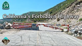
At the north limit of Azusa, adopted Route 39 begins again as San Gabriel Canyon Road. Route 39 winds through the San Gabriel Mountains in the Angeles National Forest for 22.6 miles (36.4 km) until it reaches a gate barring the road 0.25 miles (0.40 km) north of Crystal Lake Road in the Crystal Lake Recreation Area.
The last six miles of the route, including the connection to Route 2, are closed to public highway traffic, as the roadbed has been closed since 1978, due to major rock slides that year and again in 2005 which damaged more of the remaining roadbed.
#driving #tour #LosAngeles
Follow on Twitter:
(@SafetyPint): Sa...
Dashcamtours.com
![May 21, 2020 [4K] Driving on Mulholland Drive in Los Angeles. Dash Cam Tours](http://i.ytimg.com/vi/NeJ107Vnvco/mqdefault.jpg)
![May 21, 2020 [4K] Driving on Mulholland Drive in Los Angeles. Dash Cam Tours](/img/tr.png)


![May 23 2020 [4K] Driving on Santa Monica Blvd in Los Angeles End to end East to West. Dash Cam Tours](/img/n.gif)