Using QGIS and Landsat Tools to Generate a Surface Water Image

Вставка
- Опубліковано 3 жов 2015
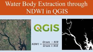
- The Modified Normalised Difference Water Index (MNDWI) product can be calculated from the green and middle-infrared bands of Landsat. This video shows how the free Landsat tools program can be used to generate the expressions needed in QGIS to calculate MNDWI from a Landsat 8 image-set downloaded from GLOVIS. Landsat Tools may be downloaded from www.ukscience.o...