I expect that, in years to come, the gold standard for SAR imaging will be aerial hyperspectral imaging that can identify areas of nylon or polyester that equate to the jacket, fleece shirt or ruckack of a missing hillwalker or the lifejacket of a person lost at sea. It might well be helpful if the military would stop pretending that they are not interested in this and that it cannot be done: a wider interpretation of the concept of defence may be required.
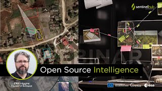
Hi Rawan, what you see are Sentinel-2 satellite images with a resolution of 10m. If you need high-resolution imagery, we offer access to several data collections from Planet, Airbus and Maxar. However, to purchase one of the commercial data packages, you'll need a Sentinel Hub subscription. See this page for more information: www.sentinel-hub.com/pricing/#tab-commercial.


I expect that, in years to come, the gold standard for SAR imaging will be aerial hyperspectral imaging that can identify areas of nylon or polyester that equate to the jacket, fleece shirt or ruckack of a missing hillwalker or the lifejacket of a person lost at sea. It might well be helpful if the military would stop pretending that they are not interested in this and that it cannot be done: a wider interpretation of the concept of defence may be required.
When I zoom in, the map blurs. Please solve the problem
Hi Rawan, what you see are Sentinel-2 satellite images with a resolution of 10m. If you need high-resolution imagery, we offer access to several data collections from Planet, Airbus and Maxar. However, to purchase one of the commercial data packages, you'll need a Sentinel Hub subscription. See this page for more information: www.sentinel-hub.com/pricing/#tab-commercial.