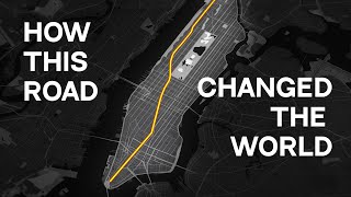
Manhattan’s Grid - EXPLAINED

Вставка
- Опубліковано 29 вер 2024
- Learn how to navigate Manhattan with this compact grid explanation.
Check out the How it Became Manhattan course at www.brighttrip...
Manhattan is one of the most intriguing cities in the world, but its street grid often confuses visitors. This short video lays out how the map of Manhattan NYC works, and will get you oriented to the key regions of the city, like lower Manhattan, the Upper East Side, or the Financial District.
We’d love to hear from you which maps and what cities you’d like to see explained, so leave a comment below!
Make sure to subscribe to the channel to learn how to travel smarter.
===== KEY MOMENTS =====
0:47 - Map Orientation
1:50 - Financial District
1:58 - Midtown Manhattan
2:09 - Upper East & Upper West Sides
2:19 - Harlem
2:28 - Avenues
3:38 - Lettered Avenues (Alphabet City)
3:54 - Streets
5:11 - Exceptions
6:58 - Broadway
===== FOLLOW ON SOCIAL =====
Bright Trip Newsletter: mailchi.mp/bri...
Bright Trip on IG: / bright.trip
Bright Trip on Pinterest: / brighttriptravel
Bright Trip on Facebook: / brighttripteam
Bright Trip on Twitter: / trip_bright
===== ABOUT BRIGHT TRIP =====
Bright Trip creates video-based travel courses to help you travel smarter. From our location courses that visually demystify places like Tokyo, London, Costa Rica, or Cape Town to our skills courses that cover how to travel solo, with kids, or how to document your travels more effectively and efficiently - each course is created by real travelers, like you, and aims to create a community of curious travelers that are eager to travel smarter.
#manhattan #travelguide #brighttrip #travelsmarter


Always thought Houston was pronounced Houston. Now I know Houston is pronounced Houston and not Houston.
Can you believe we read Houston and Houston differently? We totally get you!
I also think it’s crazy Houston is actually Houston cause it looks like Houston, I always assumed it was Houston. Lol
huh? i- all the 'houstons' are the same . i think i lost braincells reading this
@@chicoblackly3119 nah, you’re just not from NY, you wouldn’t get it lol
@@metro-sn but how do you differentiate its all spell the same
I'm not from Manhattan but I live in Brooklyn and everytime I look out my apartment window I see our beautiful Manhattan Skyline.
Proud New Yorker here 😘
Lucky you 😍
The Jersey side of the Hudson and Brooklyn have spectacular views of Manhattan at night, especially.
Those couple of miles away from the island provide a nice wide perspective.
Would love to see these breakdowns for more cities around the world!
Stay tuned, it might happen 😉
Yes please 🥺
And I thought I knew NYC. Wow, so informative.
So glad it was helpful for you!
I love to watch such videos and understand more about this beautiful world.
“Orient yourself by finding Central Park”.
In Jersey City we “orient” ourselves throughout the area by if we can see the financial district
That's so cool!
It's funny that Broadway in this video is "the little exception I have to mention at the end" - when in reality it's literally the oldest of all the roads they talk about :D It follows the path of the old trail native americans carved into the manhattan brush, later made wider by the dutch (which is where it gets it's name from: when the british took over New Amsterdam, they saw the unusually wide path through the brush and called it: "the broad way")
Wow, that's so interesting!
This little bit will take you a long way!
I finally know the "Soho"&"Noho" meaning!
Thanks for your great introduction
One of the best videos, it was really good, I thought he’s gonna miss something (as i live here) but it was almost perfect…
The most helpful video I’ve ever seen on UA-cam
🙏🏻🙏🏻
Thank you... This was soooooo helpful. I now have a general idea of how to get around Manhattan.
Glad it was helpful!
that was awesome, and so helpful for someone planning to visit and/or move to NY, NY! Thank you 😎
I’ve been to New York (Manhattan mostly, but I’ve been in every borough) every year to visit family (and I’m 22 now), but I never knew a lot of this! Thanks!
Yay! We're glad
This is so helpful with putting Manhattan into perspective. I feel so confused figuring out my location (North, South, East and West) in this city. Can you please do a video with the location and proximity of the 5 boroughs?
We'll get to work on that!
I think it is interesting that Broadway actually follows the path that the Indians used to travel to lower Manhattan to fish.
The diagonal is pretty useful!
I only watched this video to see if this myth was in here. Glad to see they didn't include it. The real trail was on the east side of current day Central Park.
@@MichaelfromtheGraves Interesting. I saw the Broadway story in a documentary. I'd like to see a link to what you are saying. I also like the legend that the Pennsylvania turnpike follows the original path that Daniel Boone took when exploring Pennsylvania.
@@MichaelfromtheGraves Thanks. Although I must admit I like romantic legends much better than the truth. LOL
@@clydelaz cartographyandillustration.blogspot.com/2015/10/wickquasgeck-trail-manhattan-island.html?m=1 here's a map showing the difference between the two. In Dutch maps of lower Manhattan, the two were the same. So I'm guessing that's the origin of it.
Wowww, I learned so much in 7 minutes! Thank you so much!
why didnt i knew about this video before going to new york? Its mega!
Best explanation by far
Yay, we're glad!
I really enjoyed this video. One day I’m going to visit NYC.
You should!
It’s been a dream of mine since forever to visit New York and I’ve often heard a lot of the places that were mentioned in this video in movies and such but always wondered what do they mean. Suffice to say, this video solved a lotttt of doubts.
Happy to read that!
Moving to NYC after I graduate!!!!
How exciting!!!!!
6:24 spelled herald sq with an o
Great video, very educational and informative!
Glad it was helpful!
this video is brilliant 👏🏻
I live in Brooklyn and even I didn't know some of this
Interesting. Thanks for making this!
Glad you liked it!
Fun fact: In fiscal year 2023, NYC issued approximately 15.5 million parking and camera violations, resulting in about $1.08 billion in fines. This translates to roughly $2.96 million in parking ticket revenue per day.
Having to memorize street numbering formulas and other mnemonics probably aren’t as important now that wifi and apps are ubiquitous. But having a primal knowledge of the city and its culture before arriving in town really lets you get the most out of your trip.
Thanks it’s really helpful.
Exactly this but for Los Angeles.
Your amazing!! Love the detail orientation in your work!
Good video. One thing I noticed is apparently the street and avenue numbers in Manhattan have nothing to do with the addresses. In every other city I've been to if, for example, a building was between 12th and 13th avenues the address would be something like 1210 (with maybe an E or W on it.) Maybe cities didn't start doing that till later. It made it alot easier to find an address before google maps.
In Manhattan, the building numbers (on horizontal streets) start from 1 (East or West) starting from 5th Avenue, outwards.
If this was a 1hour video with more info, i’d watch it all.
We do have a whole course on Manhattan, in case that interests you 😎 Find it here: brighttrip.com/course/how-new-york-came-to-be/
Loved this video
Good helpful video. Thanks
4:44 sight confusion, thought even and odd numbers were referring to the addresses. Perhaps, have this section after 4:46
See AD (Architectural Digest) Micheal Wyetzner's "Five Building Types" of Manhattan. Similiar format. Assume yours was first. He uses a Pental marker. :)
Thank you! And good point. We’ll check it out!
@@BrightTripTravel
Never understood the east and west traffic rule as far as coming up from the subway to orientate yourself, especially on an overcast day when the south street side which was usually in shade. Noticing buildings cast shadows for north and picking a tall building as a landmark helped. Reading building addresses was more helpful. Also, twenty blocks, short side, to a mile on the grid.
Of course that's a little beyond the scope of this video.
Thanks agains for a good video.
What a great video. Too bad it's not in 4K.
Awesome video
Thanks 😊
Yess watched video
Many many years ago I had a sister who lived in Park Slope near GAP. I'd go to the roof to smoke a cigarette and marvel at the Twin Towers.
HELP I'm a NYC native and I never knew what Soho/Noho stood for until just now 😭😭
Takes me back to liberty city
Want to get into an hour long debate with a native New Yorker? Ask them where does the Lower East Side begins. I technically live in the Lower East Side, but it can also be called: Downtown, Financial District, Two Bridges or Chinatown.
Better not 😱
Now do Queens!
something like this for Sydney Australia would be hilarious. No logic was used in laying out our streets.
Haha, that would be a good challenge
Lol who gets lost in NY and needs this map breakdown?
1:35
Do LA please 😂
Haarlem is named after very cheezy city (No Pun intended)
I refuse to live in NOHO, can't live without 'em 'hos.
SoHo is much more fun. Who doesn't like to go south with some hos?
😂😂😂
*BRO'S BEFORE HO'S!*
This beautiful😂🙏
@@tylerdurden639 Join us in BROHO
Union Square: Am I a joke to you?
RIP Union Square
New Yorker here! This is a really helpful and concise video for those who don’t know the city. The one thing I would point out is that you referred to everything south of midtown at one point as the financial district, which I think could be a bit misleading as it is only the bottom tip of the island. Otherwise great video
Thank you for the feedback!
Are you a real New Yorker or an incomer hypster who pretends to be a new Yorker
@Bruno Lora which part
@Bruno Lora which part do you live? I'm from London pretty much like NYC but I've always dreamed about swapping cities and living in New York.
I've always referred to the area south of 14th as "Lower Manhattan" as a general name including the Financial District, East and West Villages, SoHo, Tribeca, etc. I call the Financial District "Downtown", and usually when I say Downtown, that's what I mean, but I also just use the word downtown when say I am going south, regardless of where I am above 14th street.
A New Yorker of 43 years, great job, simple and to the point.
Thanks!
As a New Yorker for 0 years and 0 days. He did ok
York
2 26th
43 years? You must be incredibly rich to live so long in the most expensive city!
A helpful hint from a local: within the grid there are 20 streets to a mile. This means you can cover about a block per minute.
An avenue block is the length of *three* street blocks, so it'll take you about three minutes per avenue.
That means (for instance) a trip from the Flatiron Building at 23rd & 5th to Times Square at 42nd & 7th will take you:
- 19 streets = 19 minutes
- plus 2 avenues = 2x3 or 6 minutes
So you'll be in Times Square in 25 minutes if you hike it.
I used this all the time before map apps took all the adventure out of life.
PS - why isn't it pronounced SowHow?
Dang, this is super cool!
Now, is that a street per minute or a street per New York minute? 😉
The area you called Financial District should have been called downtown. Same with Harlem because Harlem is uptown, The Financial District and Harlem are specific neighborhoods. Dyckman isn't in Harlem
It was simplified for the tourists who will never go north of 110th Street.
Yeah, he lost me at the generalization of Harlem and “Financial District”. Uptown and Downtown are the appropriate references and terms that are completely relatable to most tourists.
Dykman is considered Washington Heights
@@determineddylan8793 dyckman is in between the heights and inwood but considered more inwood than the heights
I thought the same. The financial district should have been referred to downtown manhattan. That’s the way us locals calls it anyway
I have been to New York City numerous times and I can say I know my way around Manhattan. Yet, getting out of a subway station and walking in the opposite direction to where I'm going still happens to me. Don't get me wrong, getting lost in NYC can be a magical experience since you get to "find" gems along the way that otherwise you'll never get to know, but learning that even streets runs East would be a time-saver on my next visits. Thank you for a very informative video!
just don't take the A train to the empire State bldg if you are looking for it. thake the B train. the 6 train to to the Chrysler bldg if you want that. when you get out it is to your left. also if you are getting out of Gran central past th Hyatt hotel walk another block east. right on your left side , .
@@timafiggy thank you! I stay in Central Harlem, close to Lennox Ave., so the No. 3 is my usual mean of transportation, quite convenient being an express train and running on 7th ave., I might add. Although, if I'm heading East, to the museums or any of the parks or shops on 5th Ave., I would frequently use one of the the buses lines that runs on 5th, since I enjoy the sightseeing opportunity, provided it is before noon, otherwise it will take forever to get anywhere.
Lower Eastside and Alphabet City are two adjacent neighborhoods they are not the same
yeah wouldn't it be divided at Delancy or Grand?
@@timafiggy Houston street is the boarder
Super cool!!! As someone who has not been to and has only known NY through movies and videos and stories and literature, this is suuuuuuuper cool to see on an actual map! More of this please! :)
Coming right up ;)
Just came across this...a UA-cam recommendation. A few points: for orientation and navigation purposes, it's good for visitors to know that streets are pretty close to each other but avenues are pretty far apart. So, it someone tells you to walk from 28th to 29th Streets on 5th Ave, that will take you at the most a minute, but walking from 28th and 5th to 28th and 6th is a longer trek. I agree with other posters about your over-simplification of the neighborhoods. I realize you were just trying to not clutter the map, but everything north of Central Park is NOT Harlem, and there are tons of very unique and distinct neighborhoods below Midtown. It's not all just the financial district! It also would have been helpful to explain why Broadway doesn't follow the grid pattern (it was an original trail used by the indigenous population prior to the arrival of the Europeans).
I couldn't believe how well designed NYC was when I visited before google map was a thing in the 2000s. It was impossible to get lost as long as you knew the street and the avenue of your destination
Why would you would use a map that cuts off Washington Heights and Inwood? I get that's not where tourists "go", but it's a little misleading to just ignore the northern tip of the island. It's home to the cloisters museum which is part of The Met and it actually does attract a fair number of tourists.
Agree! Would have also loved to been given a list of all the 'historical spots' in Harlem that was as in depth as the list mentioned of Midtown. I think it's important to give these neighborhoods meaning when educating newcomers on how to navigate a city. Especially when that city doesn't fund these neighborhoods because they're not as touristy.
@@HolyShift27 Well said!!
Manhattan's grid is amazing. About 30 years ago, my boyfriend and I were driving from Boston to a convention in NYC, held at a hotel near Madison Square Garden. We set off in the general direction of NY without a map, just following the signs. We figured that when we got closer to NYC, we'd stop and buy a map of the city. We ended up driving right into Manhattan from the highway, like, oh crap, there's nowhere to stop, we're in it now. We navigated right to the hotel using just the address. The street numbers were counting down to the street that our hotel was on, then we just found the cross street and we were there. I was astonished, as this is very much not possible to do in gridless Boston. We never did buy a map. We had our weekend at the convention and just drove out the same way we drove in. I loved it.
NY'er here. This is a truly wonderful video. It makes a good learning tool. Quick note...did you mean to say Houston is considered 1st Street? 1st Street is a separate street from Houston though..
I lived in NYC my whole life and never connected the dots that even streets go east and odd streets go west. Wow.
Mindblowing!
Not very bright, are you?
no same learned so much and i lived here my whole life
@@markfox1545 Not very nice, are you?
Learned it when I was a bike messenger
The broad strokes here are great, but you're playing pretty fast and loose with neighborhood geography. Claiming that everything below 14th is the Financial District, for instance, is like saying everything between 14th and 59th is Times Square.
Also, the area circled and labeled as NoHo is...mostly not NoHo. NoHo is a very small part of the area circled. Most of the area circled is Greenwich Village and the East Village. NoHo is a little wedge between them. Do not call Greenwich Village NoHo, New Yorkers will laugh at you.
And good god man what have you done to Lower Broadway!?
Thank you for bringing that to our attention!
The financial District does not go all the way up to midtown!! Also, Harlem is not everything above the park. Also, the Lower East Side does not perfectly overlap with Alphabet City. The Lower East Side goes well past Houston St.
See what you started! Agree with most of the comments. For people not to argue about smaller areas, Harlem takes up the North of Central Park, between the two Upper Sides, to about 155th st. At this point, saying even "the Heights", people will get the idea you're up in Duke Ellington land.😀
Right? I’m mad he put FiDi instead of downtown! FiDi is considered ‘lower manhattan’
@@JoseNunez-hh1yr yeah on 8th to St Nicholas and edgecomb once you get to broadway it's the heights. that starts on 149th and Broadway ,
Hey, Keema😀. Interesting you think the "Heights" start at 149th? I thought it was more 168th(Washington Hts.),
but then Morningside Heights starts at 145, overlooking the Polo Grounds, so if that's the "Heights", okay.
I'm not even planning to go to NY but I thought this was amazing. Fantastic job guys. I'd be interested to see New Zealand travel guides! It's a wonderful place
Noted! 😉
Informative video but for those watching this before visiting nyc for the first time, there are a few inaccuracies that are worth pointing out:
1:30 - No one in their right mind refers to the entire area from Union Square down as the Financial District (FiDi). FiDi is essentially the southern tip of the island. If you're trying to go to union square or Houston street, etc. and ask for directions to the Financial District, you will be sent very far out of your way.
Along that same vein, I would also argue that Midtown does not go nearly as far south as Union Square, but that's not as egregious.
You can actually see this in the photo at 2:00. The tall buildings in the foreground are FiDi, and the tall buildings in the background are Midtown. That entire huge area of more low-lying buildings in the middle are almost entirely residential neighborhoods that are completely glossed over in this video.
2:24 - "The further uptown you get the more residential it becomes" statement isn't accurate. Yes, the neighborhoods uptown are mainly residential, but so is the massive area between Fidi and Midtown. In fact, many downtown neighborhoods are some of the most densely populated in the city.
3:03 - 4th Avenue is called Park Avenue for literally its entire length except for a small stretch between Union Square (14th Street) and Astor Place (8th Street), not because it's just in a particularly fancy part of town.
3:10 - Both Madison and Lexington Avenues span far longer than just the Upper East Side (UES). Both avenues pass through the entirety of Midtown and Harlem, as well as some downtown.
3:50 - The area circled is not all Alphabet City. Alphabet is only the upper half or so of the circled area. Lower East Side is the lower half of the circled area and is a distinct neighborhood.
4:20 - SoHo and NoHo are small neighborhoods that, yes, are located below and above Houston Street, respectively. But absolutely neither one covers the entire area below or above Houston. For example, nobody from New York would call the Lower East Side SoHo or the West Village NoHo.
4:58 - Yes, the two-way streets are exceptions to this rule, but there are also a few special case exceptions even with specifically 1-way streets. For example, both 60th and 61st streets on the east side flow West.
6:25 - Forgetting the pretty significant Union Square here on the intersection of Broadway and Park.
Thank you for clarifying these things, we appreciate it 🙌
Yes to everything here. The only one I didn't catch was the 4th Ave. point.
81st between Columbus and Amsterdam also flows east to aid the flow of traffic around the Museum of Natural History and to the 79th St. Transverse.
@@BrightTripTravel haha taking this like a champ, W
Since you mention Broadway and the various Squares, it's interesting to point out that Madison Square Garden is not, in fact, located on Madison Square. How it came to be built above Penn Station (at West 34th Street) is a whole other story.
I had to stop and laugh cause don’t think we missed that after you misspelled “midtown” there was a cut for “financial district” 😂 to be fair I feel like if sharpies have some sort of inbuilt curse that makes spelling harder because you know there’s no erasing
6:12 Columbus Circle is a traffic circle, not a roundabout.
Traffic circles use traffic lights/signals while roundabouts lack these stoplights and are generally smaller than traffic circles.
I will circle back around in a roundabout way. I will go around in a circle.
Roundabouts lack stoplights and are generally smaller than traffic circles while traffic circles use those traffic signals/lights.
Columbus Circle is not a roundabout but rather instead a traffic circle. 6:12
In the uk that would still be considered a roundabout interesting
Even flows to the East, never knew that before, helpful tip.
the trick about orienting yourself out of the subway is much more useful when thinking about the avenues because of exactly what you said - the main streets that the subway stops stop at are two-way, like 23rd, 34th, 42nd, etc. Even avenues go north and odds go south - much more helpful when orienting yourself than 2-way streets!
Fucking Broadway that curves as it pleases. It makes navigating more confusing cuz I use avenues as a guide to where I am in the city, but Broadway can be fucking anywhere across
I’m sure this guy knew the moment he posted this video there would be an avalanche of people screaming and crying about every minute detail of this video…
This was great. I am a geography and map nerd and this kind of thing fascinates me. I've been to NYC a few times and absolutely love how well organized the grid is and have always found the subway very easy to navigate. You are very right though, about not trying to use a subway map to guide you above ground. It's similarly easy to get around above ground, but in a slightly different way, which may sound strange but I'm sure you know what I mean :)
We’re so happy you liked it! Have you watched our San Francisco video yet? 😊
@@BrightTripTravel Yes! The SF one was very interesting, I had heard about the reclaimed land but not to that level of detail. I'd love to see even more cities!
Ngl the map looks like a GTA map. We just need cheatcodes lol
Gta5 is located in Los Angeles
duh gta maps are based on american cities...
Well, it is a gta map
Shout out to Algonquin
who else lives in new york but is watching this
I cant see how this would ever be useful to me but you do a bloody good job of explaining thank you👏
Glad you enjoyed it
We call the Financial district lower Manhattan
*Avenues from east side to west side (MIDTOWN between 34th and 42nd)*
1st Avenue (one-way, north)
2nd Avenue (one-way, south)
3rd Avenue (one-way, north) _two-way below 23rd st_
Lexington Avenue (one-way, south)
Park Avenue (two-way)
Madison Avenue (one-way, north)
5th Avenue (one-way, south)
6th Avenue (one-way, north)
*Broadway (one-way, south)*
7th Avenue (one-way, south)
8th Avenue (one-way, north)
9th Avenue (one-way, south)
10th Avenue (one-way, north)
11th Avenue (one-way, south)
*Major cross streets*
Houston
14th
23rd
34th
42nd
57th/59th
72nd
79th
96th
106th/110th
125th
135th
145th
155th
i live here why am i watching this? great video though,very informative, I even got a history lesson lol. one general rule for tourists is to stay above 14th st cause below that is where there are no rules to the street geography and youll get lost🤣🤣
Hahahah, great tip 😂
Funny cause the mantra for locals is to never go above 14th street
I'm a New Yorker here, but I live in Queens, and well, I have just learned new things about the city. First of all, I didn't even know that there's a roundabout in the city! and now, the MTA central park is now going to haunt me for days
Hahaha 😂
I'll keep this in mind, although I'll probably die without visiting New York, sadly.
The buildings are taller and bigger where the bedrock can support the weight. Financial district and Midtown are examples.
I know this is for tourists, but there's a lot that was wrong here. Midtown ends at 34th Street and the Financial district only begins South of Chambers Street. Everything in between is largely residential or small-scale retail. And the direction of flow thing is only true below 59th street. Above it, the order switches back and forth at the two-ways.
I hope Bright Trip grows to become a successful Company!! Y'all deserve the recognition!!
Thank you SO much!
Excellent 👍. I am going to NY 2 weeks from now. This video will surely help me a lot.
Thank you for your video. It's very helpful.
NECESITO VERSIÓN EN ESPAÑOL O SUBTITULOS PORFA AMIGOO😭
This was sooooo helpful! I dream of living in nyc and watch lord of youtubers from the city and now I’ll feel way more oriented to the locations they discuss.
Yay!
Fantastic video
I love it
I learned a lot
Thank you very much
Have a wonderful day
A little quick edit during the spelling of ‘Financial’. 😉
amazing video thanks for sharing
Glad you enjoyed it
No love for the heights & Dyckman... 🤦🏻
Man yall get love
actually love is for Dyman. Harlem girl here. if you cross the Bridge to the Bronx it's Fordham Road. so at least yall dont have to worry about a train. i had to take the D for fordham and the A for Dykman from 145th and St Nick.Good times in the 90's. that pizza shop on University wa everything. we only had ours on lenox but my fav in the bronx was that. in manhattan was the rays on 97th or the one that gives the giant slice on 11th by Columbia University.
Fantastic video! Moving to NYC and hoping you can do this for all boroughs, especially brooklyn!
ooo yes! brooklyn would be great!
@@BrightTripTravel That one won't be easy. Brooklyn is mostly a grid, except it's really like 19 different grids all mashed together lmao. I live on East 7th Street, and I'm like 6 blocks away from 35th street.
An excellent concise, entertaining and informative presentation. Love the format!
Glad you enjoyed it!
but, Can you tell me how to get, How to get to Sesame Street?
😂😂😂
Does anyone think it is weird that Gotham and Manhattan look almost identical
Wait, Alphabet City is correct, but Alphabet City is not the Lower East Side. The LES starts below Houston Street.
You forgot to mention Union Square!
Tbh I love how Manhattan's street layout was designed, main, long avenues with smaller roads cutting them into grid sections, with the FDR Drive outlining most of the island, everything well thought out and improved for centuries, amazing
The FDR Drive is only on the east side. The Westside Highway is on the, well, west side.
@@yutubetom ah, I mistook it with its equivalent from GTA, my bad