A technique to track Earth’s subtle movements with orbiting radars is heating up

Вставка
- Опубліковано 4 бер 2021
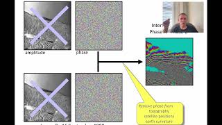
- When you imagine satellite imagery, you probably picture crisp photos of Earth taken from orbit. But another technology used to image the planet, synthetic aperture radar (SAR), is heating up, following a surge in public and private satellite launches. SAR satellites use radars, not cameras, to take snapshots of Earth. Comparing two SAR images taken at different times from the same position, a technique known as interferometric SAR (InSAR), can reveal surface movements of just a few millimeters. Watch the video to learn how InSAR is transforming earth science-and what to expect from the technique in the coming years.
Read the feature: www.sciencemag.org/news/2021/... - Наука та технологія


Excellent talk. Can you please upload any tutorial using GEE to calculate this phenomenon. Thank you so much
This should reaveal how huge sinkholes in Siberia permafrost are created.
Stunning & brilliant! What a scale!
How amazing tool!!!
NICE!!!
Oooh, spooky! So cool!
Wow.
3:24 vat ver dey sinking about? 😀
Har har! Good stuff.
Matrix or skynet? Eerie sensation creeps in ... Technically amazing though.
China wants your number...
Will I need a tinfoil suit to go with my hat....? 🤔