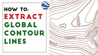
How to extract contour lines from Google Earth and export to Revit

Вставка
- Опубліковано 7 лис 2020
- How to extract contour lines from Google Earth and export to Revit
GPS Visualizer link:
www.gpsvisualizer.com/elevation
Please SUBSCRIBE for more tutorial!
Additional tags: site, google earth, revit, gps visualizer, contour lines, BIM, revit online tutorials


For anyone wondering, this tutorial works fine still. Just follow it step by step and make sure you pay attention to whether you're downloading files as CSV, etc. Also - I didn't use the zone that he used (UTM 14N), because that wasn't where my site was. I found where my site was located in relation to those zones on the map.
How to know about the coordinate reference system of any particular area..like yu selected Ut zone 14N??
when i try to Export > "Save Feature As" it gives me this as a response.
Export to vector file failed.
Error: Feature write errors:
Feature creation error (OGR error: Failed to create .\contour.csv:
Permission denied)
any ideas?
I cannot map the freeway and street, is this method only for sub urban area?
the topography went out of scale when i imported the csv file into revit :(
hello I am following all your steeps but when I have to export elevation, I just got option to save as type: *.gpkg PLEASE HELP!!!!
same
Can Notepad be used instead of textpad?
No not possible
Please reply
oh my god that's so complicated is there any other way to do it?
Yes. Use QGIS instead. Download the DEM files from USGS or whatever source has DEM data for your area, and keep them as a layer in QGIS. Whenever you need contours for an area, clip the raster extents to your lot, generate contours, save as DXF. Some areas of the USGS data is 1x1 meter and accurate to about 3cm vertical.
lol obvious cut...this doesnt work at all anymore.