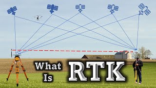
RINEX - Online GNSS Data Processing - AUSPOS / CSRS / OPUS

Вставка
- Опубліковано 19 вер 2024
- *01 Aug 2023 - New updated video uploaded • The #RINEX Data & Proc... *
Receiver Independent Exchange Format or #RINEX in short, is a data interchange format for raw satellite navigation system data. RINEX enables storage of measurements of pseudorange, carrier-phase, Doppler and signal-to-noise ratio from #GNSS that is GPS, GLONASS, Galileo, Beidou along with data from #EGNOS and #WAAS #SBAS and #QZSS simultaneously.
RINEX was first developed by Werner Gurtner in 1989 and it was only supporting the GPS. But by 1990 RINEX was supporting GPS as well as GLONASS. The most recent version is RINEX 3.05 from December 2020 which supports all constellation from US, Russia, China, European Union and Japan.
Since January 1994, International Association of Geodesy began operation of establishing ground GNSS stations around the world, including in Antarctica. These stations provided GPS orbits, tracking data, and other data products for those stations. The International #GNSS Service or #IGS is now the world’s largest GNSS organization, with over twenty five years of history of providing freely and openly available high precision GNSS data and products. There are 508 IGS stations, representing over 45 countries. IGS data and products are openly available to all users for use without restriction, and are offered free of cost or obligation.
Before you can download the free station data, you need to register yourself. It is free. Once you have logged in, you can first go to Directory by year and then by Julian day. To process RINEX data you need mainly Observation and Navigation data, Observation data is in O directory and Navigation data is in N directory. In this directory, you can search for the required station data and simply click to download.
Now you can process your RINEX Data and Downloaded IGS reference station data in various third party software like Trimble Business Center #TBC . Its a Time consuming effort. But if you want your data rather quickly, then I recommend some online PPP sites, where you can upload your observed RINEX data and get your data processed quickly.
*Here are some of the free sites you can check out which are very useful*
AUSPOS - gnss.ga.gov.au...
CSRS - webapp.geod.nr...
OPUS - www.ngs.noaa.g...
Trimble GNNS Planning www.gnssplanni...
*Recommended Video to Watch*
How & from where we measure Tide | Tidal Datum- Part 3 • How & from where we me...
What is a Vertical Datum? How to Measure Tide Inside A River? • What is a Vertical Dat...
How does a GPS Work? Introduction to GPS | GPS 101 • How does a GPS Work? I...


As a beginner in the world of GNSS, GPS and GIS, this was one of the most enlightening videos I found. Thank you, sir. Much appreciated.
Its my pleasure. Thanks for visiting.
I got a latest and updated video on RINEX that you may want to see - ua-cam.com/video/TAChKe0HJMo/v-deo.htmlsi=GQaZMr2YDwRiEdzo
Extremely informative thank you so much
@@mennabababah76 happy to help. There is an updated video on the same subject if you wish to see.
A lot of very relevant information which a surveyor can benefit from. good work.
Thanks
🙏U have given almost all the information about rinex sir...saving this video...TQ..
It's my pleasure
A very beautiful presentation. Explained nicely. 👍
Thanks a lot 😊
Very interesting and useful information clearly explaining. thank you so much
Hi, This is Old video. There is an updated video on my channel which can be more useful ua-cam.com/video/TAChKe0HJMo/v-deo.html
Thank you very much that was very knowledgeable 👍👍
Hi thanks. There is newer version of RINEX video you may want to check out. Thanks for watching.
Such a nice posting..great
Thanks for your super quick response within 5 sec of video publishing. 🙏 Hope you did see the video completely before commenting 😂
Thank you for your videos. from 🇰🇷
Hi Thanks for watching. I got a latest and updated video on RINEX that you may want to see - ua-cam.com/video/TAChKe0HJMo/v-deo.htmlsi=GQaZMr2YDwRiEdzo
Very informative video,Thannk you Sir
There is a new and updated version of RINEX video that I think you like to watch.
Very informative, nicely explained. 👍👍👍
Thanks Milan. I hope the video was useful.
Nice presentation with simple language
Thanks Devender
Thank you very much
You are welcome, hope you will like my other videos too.
Sir,you are simple the best sir.
Sir can you help me with vessel calibration and survey sensors video.
I mean dimensional control.
Hi, Thanks for your kind words 👍 I have a video on Heading calibration you can check on my channel. Dimension control survey needs some precise equipment like Total Station with scanning laser. Then you need certain software to process the point clouds. Frankly I may not be the best person to advice you on DimCon Survey. But I believe there will be Tons of videos on UA-cam on DimCon.
Good one. 👍
Thank you
Excellent
Thank you Mr. Drifter 😉
Thank you very much do you knew something about note (( OPUS PROJECTS now supports PUBLISHING and RTK: ))
Thank you too
Hi sir, i am new to this GPS surveying and i am learning about this. Your videos help me alot to understand this system.
Sir it will be very helpful if you make a video about static data of main boundry points processing through auspos and rest points inside boundry with that processed boundry points.
Hi, thanks. You might want to check out the newest RINEX video. See what you are asking involves using various software from Leica or Trimble to process and do the network adjustment. But I am sorry, I can not make any public video on any proprietary software.
It is a great video. Touched lots of points but didn't take to a conclusion.
Like you mentioned about IGS service. But didn't mention how do we process that data. Is it good for all India coverage? You mentioned about PPP service but again didn't say which is better for Indian subcontinent.
Hi @Ravi Singh, Appreciate for taking time to see the video. I understand what you are saying and you are absolutely correct. If you see I most of the time dont give the full answer. I believe in creating curiosity in the mind and if you are curious, and take you time to explore and learn by your own then that learning will stay with you forever. I am here just to show you the way just to make you curious.
Also as I am from a offshore surveying company there are many information I can not officially say on open public platform. I hope you will understand.
Thanks again.
(Yes IGS processing is good for all India, But you dont get the precise ephemeris any more and its just broadcast only. So yeh, if you are looking for establishing a reference station, You can use Trimble or Leica Software to process the data or use PPP service. I have thoroughly checked AUSPOS, CSRS and OPUS with various data from east to west coast of India and they all agree within 5cm of each other. So its all good I guess)
@@JAOM I do understand your thought. I am curious enough I guess. I had tried IGS in the past but their data is not properly archived. Had tried NRCAN as well but didn't had anything at that time to cross verify the data. Came across your video and it reignited my thoughts. Thank you for providing the insight. BTW what is the name of your company?
@@RaviSingh-wk7qk Fugro
Good Day, Sir. By any chance, do you know how to compute the satellite position using the navigation file? Thank you so much.
Hi Jean, what do you mean by navigation file? What is the file extension? Is it .22n or .21n or .Dat file?
@@JAOM Hello sir, I sent you a message to your email address.
The data that I have are the ephemeris data (observation and navigation data). By any chance, do you know how to compute the satellite position with the use of these data?
@@JAOM the file extension is .19n, Sir
@@jeanpepito2715 okay, .19n means the data was recorded in 2019. If you have the n file, you should also have the .19o file. O is the rinex observation file which can be uploaded in any ppp site I mentioned in the video. Only n file will not give you any position. These are ascii files, try opening the file with notepad or text pad and see what info are there. But if you want position data then you need .19o
@@JAOM thank you so much, Sir!
Sir, I work with timing rx whose position is fixed. I am interested to know about GPS calibration (like its various delays etc). Could you through some light on the topic.
I do have some videos on my channel where I discussed a little bit about calibration. To be truthful, as I am working in a company for same line of work, some processes are proprietary and I am not at liberty to discuss that. GPS receivers are best calibrated on a known station. But as the known station itself moves, we need to first determine the exact location of the known station on the day of the observation. So calibrating your GPS with the data of different IGS station (within 2000km of your location) (network.igs.org) by Long Baseline processing can be the best option. Do note that AUSPOS site can only do processing of GPS satellites and not glonass and galileo. I really need to update my video.
@@JAOM Please update ur video and send the link.
@@kandpalpreeti1 I will, I have the material and resources but not getting enough time to make the video. I have too many pending things and trying hard to catch up.
i want .o .n file parsing so that from it we can get the Orbit cooredinates and the clock corection
Please tell me about SPSO for post processing
I have not used SPSO but I did use TBC long time back. Most of the time you find a RINEX file with t02 extension. There are tools to convert them in .23O file. Some online post processing software do accept t02 version. But if you have GLONASS data embedded in your RINEX data that could also give some problem as AUSPOS does not process GLONASS and will reject entire data without giving any explanation. So better use a GPS (BX982 / BX992) where you can select specific GPS data sets to be recorded as RINEX data. Well anything beyond this... I practically do not know. As technology and software are changing on daily basis, it is hard to keep up.
Sir, How to process MET data of the GPS?
@kandpalpreeti1 to be frank, in my line of work I have worked with only observation data like xxxxx.23o - Navigation and Met data I myself have never tried to process. So this is a new and very intriguing question for me and I fully understand that Met data can be very valuable for Atmospheric and Tropospheric knowledge. My video is actually outdated. For quite some time I am planning to make an updated video. I will make sure to find the answers to your question and release an updated video. Thank YOU very much for being here.
@@JAOM Thanks for ur reply sir.
@kandpalpreeti1 Hi, please see if this helps or not. sorry but my expertise runs out here. ua-cam.com/video/TAChKe0HJMo/v-deo.html
Sir I need ur help
How can I contact you sir
Sorry but I am not at a liberty to contact anyone directly except replying here in UA-cam and that also on relevant topics on relevant videos.