Learn Map & Compass with Andrew Skurka, Part 2: Find and transfer bearings in the field and on a map

Вставка
- Опубліковано 1 сер 2024
- In our first video on map & compass, National Geographic “Adventurer of the Year” Andrew Skurka explained how to adjust for declination with a magnetic compass. Watch it now, • Learn Map & Compass wi... .
Once you know how to adjust for declination, you can orient a map (also explained in the first video), and find and transfer bearings in the field and on a map (the subject of this video). Learning map and compass is a critical for hikers, backpackers, hunters, and many others -- with these and other navigation skills, it’s difficult to travel far or confidently from trailheads and well maintained trails.
Finding a bearing can also be called “taking” or “shooting” a bearing. Transferring a bearing is also known as “transposing” or “plotting” a bearing.
To learn how to find a transfer bearings in the field and on a map, it is best to learn four steps independently:
* Find a bearing in the field
* Transfer a bearing in the field
* Find a bearing on map
* Transfer a bearing to a map
But in practice, two of these steps are always combined. Specifically, you may find a bearing in the field from your current location to a magnificant peak, and then transfer that bearing to the map to learn the name of that peak. Or, you may find a bearing on a map from your current location (although it does not need to be) to a secluded lake, and then transfer that bearing in the field so that you can begin walking in its direction.
These two videos represent the extent of useful compass skills. Triangulation is another skill that you will hear about, but it's primary purpose is to "find" yourself after you've become twisted around. It's better to "stay found" by always comparing what you're observing in the field with what you were expecting. If there are inconsistencies between your navigation data from your watch, altimeter, map, compass, and GPS, stop and figure it out.


By far the best orienteering video I’ve watched on UA-cam. The key Andrew was when you established that one could establish a bearing directly from the map without even referring to the magnetic indicator. As soon as you said that, it was like the veil was lifted and everything was clear: declination, how magnetic north interfaced with true north. Instantly things went from a troubled haze of confusion to finding it easy and straightforward. With an upcoming backcountry trip into the transcontinental divide in Yukon/NWT this comes a relief.
Only had to watch once, with you actually showing real time at the end was what put it together for me. Heck yeah I'm pumped, now I just need a compass lol
Great video! Thank you for being an articulate and clear American that can teach how to use a compass to a knucklehead like me.
Amzing video, I wathced the video few times and read all the comments, great tips from Fran Serna:
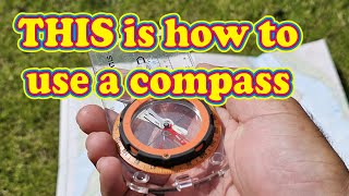
Going over the the tasks with assumption that campass been adjusted for declination (Between TN & MN) which was covered in your part 1 video (was great video also). 1- Find a bearing in the field: Point to the landmarks and rotate the dial until "Shed in the red"
2- Transfer a bearing in the field: Rotate the dial to bearing (i.e. 220) and rotate our body until "Shed in the red")
3- Find a bearing on map: Mark the S (start point) and D (destination point) with strieght line, rotate the dial, Use meridian lines ("lines match N - S") important: make sure in N - S line with TN in the map)
4- Transfer a bearing to a map: rotate the Dial to bearing (i.e. 225), find the landmark on map, rotate the entire Compass, Use meridian lines ("lines match N - S"). important: make sure in N - S line with TN in the map)Andrew, I have one question? when you need to orient your map, in all above finding and transferring bearing did not noticed you every orient your map, except on video part 1.
Great video Andrew! As you suggested, I had to watch it a few times while taking notes and going through the motions to get it. In doing so I noticed two relationships that helped me to better grasp the steps:
Tip # 1
Working on the field? Use magnetic needle ("shed is in the red").
Working on the map? Use meridian lines ("lines match N - S").
Tip # 2
Finding a bearing? Rotate the dial.
Transferring a bearing? Rotate the entire compass.
a trick : watch series on flixzone. Been using them for watching lots of of movies these days.
@Jayceon Julien Yup, I have been using Flixzone for years myself :D
Thanks, Andrew. Your video is very good and very helpful thanks.
Andrew, really well done video with tons of information and great examples. There's def. enough there for a good amount of practice.
Very good. I can't wait to see where this series is going. I hope to see 3 point fixes and running bearings for long distance travel.
Very nice video!!! Very well done and easy to follow and understand. It makes me want to run out and practice.
Thank You Andrew !
Excellent, you’ve combined probably 3 videos into 1.
Clear and precise.
I think it’s important to make mention of the Back bearing for us newbies. But good tutorial.
loved this video this man explains things really clear unlike a lot of others and I end up really confused
Is there like an even more basic way of learning because I found this very confusing? He could have spoken Japanese and I would have understood just as much.
awesome! love it and very understanding.
excellent tutorial! Thanks
Fantastic video. One of the best I've ever seen on the topic.
This is very helpful, thanks :)
This was good, head not spinning really, I liked that it was repeated and all done outside, as you would do it.
Very good one indeed except the resolution of the video is very hard to see the bearing/degrees and the N-S lines on the map. But I did learn so much from it. Thanks!
Good information
When finding a bearing from a location like you did in this video (i.e., 330 degree bearing around 5:20 mark), don't you need to add or subtract the declination from 330 if your compass is not adjusted for declination? For example, I'm in Maine and would like to know where 200 degrees is from a point I'm at. Wouldn't I need to subtract the 17 degrees declination (or whatever is listed on the map) before placing my compass on the map? And if located west of the agonic line, wouldn't you add?
Nice!
Would’ve been nice if you accounted for declination in this video
A query about this vid Andrew. At the point where you are finding a bearing to the rocky out-crop you say you find/need a bearing of 305 degrees. However the red part of the compass is pointing to the 3 O clock position. Surely it should be pointing to the TOP of the map where true & magnetic north are. Have I missed something here??
Now what about if you have only a topo or a phone, and your watch that has a compass. How do u find then where u are, and if i want to go in a certain direction how do i find it with it? I would love to see a tut...about that.
good day Andrew . Regarding taking and shooting a bearing. We (rei outdoor school) distinguish shooting a bearing as going from the map to field and taking a bearing as going from field to map. I do caution students that nomenclature among navigational books, on- line tutorials and organizations are lacking consistency . I think that is why map and compass continues to be a popular experiential learning platform as opposed to a "learn the terms' and "read the book" platform.
The shooting vs. taking a bearing, the way you explained the terms, is helpful.
Andrew, I do know where I am physical at with a compass to put on the map ?
it is different in the southern hemisphere do you have a special grip technic advice for your compass and map handling over there for us
So it doesn't matter if you have a 1:50k or a 24k or a 62k map, they all are 1000 meter grid lines right, so I can use my protractor 50k scale and get distance and azimuth? . I'm I correct in that assumption?
Andrew - Is it necessary to use magnetic declination if (1) You set your GPS to output magnetic bearings, and (2) You always orient your map to magnetic north (at the location in which you'll be hiking) before shooting (map to field) or taking (field to map) any bearing measurements? Thanks!
Scott Drumm I wanna help you but I'm not sure I understand your question. Let me try. Basically all topographic map and GPS receiver use the true north. There's magnetic declination indication on almost every topographic map so people who use a magnetic compass can use this map. The magnetic declination is usually small sometimes you can ignore it for a coarse point positioning. Use any measurement with the magnetic compass and correct it with the magnetic declination to transfer your measurement to the map. If you use the GPS receiver, the bearing is the true north, just use it, you don't need the compass anymore. The magnetic declination only matters if you intend to use only compass for Precision navigation (in case you want to turn off the GPS to conserve the battery). btw, some newer GPS receiver can use a sattelite image or a topographic map as the background map, use this feature for easier navigation, first is capture the image (scan the map or screen capture it from Google Earth or Bing Map), adjust its position using the supplied software from the GPS manufacturer, when you done, save that image into its memory card, now you can navigate and view your trails with a background map.
Are there more coming? I can only find the first two of the series. Thanks, great info so far
overload889 These two videos represent the extent of map and compass operation. there are a few other things you can do with it, eg triangulate your location, measure distances with the ruler, but these videos are the core.
Andrew, excellent video. My only suggestion is that you try to cover a bit too much in eight minutes. Might be better to break up the separate skills into smaller chunks. And thanks for showing the Suunto M3, one of the best compasses for the wilderness traveller.
Open to that idea, but uncertain how to cover this subject fully if it were broken up. Declination and orienting the compass is taught elsewhere; those seemed like they could be standalone lessons. But how would you break this up? Finding and transferring bearings go hand-in-hand.
Andrew Skurka: The most bad-ass hiker since Emma "Grandma" Gatewood.
I have watched about 2 dozen compass videos....not a single one has mentioned where to purchase the topographical maps. Is there a store or a website that sells them for my location? Thank you.
Bob a variety of places sell them. Check out caltopo.com for customizable maps. Mostly free to print. The host also has a detailed post on printing maps
andrewskurka.com/printing-exporting-topographical-maps-from-digital-sources/
Question for you, Andrew…a couple of other videos that I have seen say to put the needle in the doghouse when getting a bearing from a map. They were ignoring the north/south lines on the map which is contrary to how you explained it. Who is right? Thanks for the great videos!
I believe either way would work, I had seen the others also , this way is more like using a protractor
@@robertboyd3863 Thanks, Robert :-)
What brand is the adjustable compass? I would like to get one like that! :D
Suunto M3-G, andrewskurka.com/2016/long-term-review-suunto-m-3g-global-compass-adjustable-ultralight/
When you use a magnetic compass, make sure you stay away from steel structures, it affects the measurement.
If Andrew is hiking 33 miles a day, how does he have time to look at a map and compass?
You didn't add the 8° declination?
SUUNTO! SUOMI!
you need to tell them not to place the map an on a rock like the one video I saw the rock had a brown looked like iron oxide (rust) and he placed the map and compass right over it that will screw up your reading completely put the map on your lap or fold it for the section you need if the rock has any metal in it your screwed the minerals are all over when your out there I found 32 pounds of black onyx (natural black agate) be careful about where you set up for reading your map
He was transferring a bearing onto the map, so the magnetic needle didn't really matter in that specific situation, only the meridian lines and the bearing itself. But yeah generally rocks and compasses equal bad news
Kenny, it would matter at all if he put the map on a rock or a metal table, as when you use the compass on the map you ignore the magnetic needle.
I don't think it matters cause he is not using the needle
rust is not magnetic and steel is not found in nature.
im confused, did u mention declination at all?
In transferring bearings from map to field, and visa versa, why didn't Andrew make any adjustments for declination when going between true north on the map and magnetic north in the field?
The map has no declination. Straight up on the map is north; right is east, etc. Declination only needs to be accounted for when finding or transferring bearings in the field. I do this correctly in the video, but may not have explained it fully because it was covered in the first video. My compass was already adjusted, so it was simply a matter of "red in the shed." With a non adjustable compass, I would have needed to keep the needle 9 degrees to the east/right of North on the bezel (in CO).
@@skurkaandrew So correct me if i am wrong, (i have been know to be wrong) if your compass does not have an adjustable declination you are supposed to ADD the declination to your bearing if you are taking a magnetic bearing to map and you SUBTRACT the declination if you are taking a bearing from map to magnetic bearing . It has been a long time but i believe that is how we did it in the Military.
@@skurkaandrew OK, but you clearly said you were in CO, with an 8 degree declination. Once you spin your outer bezel, just "putting the red in the shed" doesn't account for declination. If someone in Washington followed this video, they'd end up miles off their targets.
Yes it does because his compass is already adjusted for it. It’s dialed into the back side of the compass to bias 8 degrees
Transferring a bearing from field to map= you are somwhere on that line, of course supposing the feature on the map and what u took the bearing on are the same place!
Hahaha, that auto-generated opening subtitle. Gold.
"Hi, I'm a jerk with Sierra Designs..."
Was map north in fact magnetic north? If so, an adjustment for declination would be needed. Otherwise, a great briefing.
Thanks. Refer to Part 1 of the series for his explanation of declination, ua-cam.com/video/NWaR_hWqm4E/v-deo.html.
yup, part one covers declination well.
@@SierraDesignsGear So I watched part one, good explanation of declination and orientation, but then you never mention it going from compass to map or map to compass. If you shoot an azimuth, that's magnetic, but the map is True, so why don't you subtract the declination? Also, why not add it when going from map to compass? With a 10 degree declination, after walking 10 miles, you'll be almost 2 miles off course! Why did you not account for declination?
Only need to take declination into account if you are using a heading off of a map in the field
My mind is totally spining indeed! :D
how does this work in the Florida everglades?
No difference, as far as finding or transferring bearings. But you will need to adjust differently for declination. It's 6 degrees west, not 9 degrees east like it is in Colorado (the in the videos). So your needle pulls to the left/west of True North, not to the right/east like it does in CO.
I think you were using landmarks to figure out where you were and then setting your bearing with that info. In south florida there are few landmarks. The best you can hope for, I think, is "which way is up" :)
okay, got what you mean, esp since I grew up in the East. With no visibility, you mostly find bearings on the map (from a known point) and transfer them to the field. Little opportunity to find a bearing in the field (besides to a tree, which will not be on the map) and transfer to a map.
Stand up on the seat of your boat. Look around as far as you can see. Sit back down and think.
@@stevek8829 Paying mind to the direction of the sun or doing the sun/stick in the ground move first might be more helpful with no glaring landmarks. Then transferring that information to watch/compass use. If you're hella lost anyway and generally know if you head east you will hit land or an established road of some sort.
Turn on close-caption and watch the intro.😂😂
or just buy a GPS
Very poor description and short riff on adjusting declination.
So you are teaching Compass usage. Are you aware of the fact that you are using the wrong term? The reading that you are calling a bearing is called an azimuth not a bearing. I read through all of the comments and I am sad to say nobody even pick this up so unfortunately you are propagating this information about navigation. Look up the term bearing as opposed to Azimuth
Sorry spy, in real world of basic land nav. the two names are interchangeable, the use of Azimuth is usually used by the military. So I would suggest there is no confusion just Symantec! However, get into the world of Astro nav. then I would probably agree. Regards
Hello,
I did further research and found I was wrong. Sorry for being a dope. I will retract what i said and say you made a fine video.
Wow you are the only one who has said orientation of the map is not necessary in the field,,, and you are teaching this? Really?
Trackhoe075: You don't need to orientate the map to transfer bearings to / from compass (as long as you realise that the top of the map is North).