大きな被害を受けた岩手・田野畑村[震災3日目]

Вставка
- Опубліковано 25 лис 2013
- Tanohata village of Iwate prefecture suffering great damage (Third day following the earthquake)
The Japanese text is followed by an English translation.
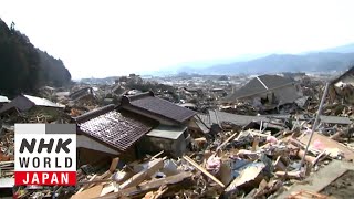
津波の被害を受けた岩手県下閉伊郡田野畑村・島越地区の様子を捉えた映像(震災3日目 : 午後3時ごろ)
海岸線から約800メートル離れた松前川の付近、川は、がれきだらけで、橋の欄干を原形不明のさまざまな破片が覆い尽くしていた。
川に面する松前沢の住宅地は、家々の土台のみが残され、どの家屋跡も、上部の建造物は全く見る影もない。
松前川付近から、集落の中心部(海岸線の方向)へと足を進めても、見渡すかぎり、周囲一帯の住宅地は壊滅状態。一面に広がる家屋・家財がれきの中に、波に流され、破壊された自動車の残骸が点在している。
集落のいたるところで、消防隊員らによる、大規模な捜索救助活動が展開されていた。倒壊した家々、1軒1軒に声をかけ、人の気配を確認して回る隊員たち、重機でがれきを取り除く隊員たち...、目前で行われるさまざまな場面を捉えていく。
島越地区のシンボルでもあり、この集落を南北に縦断する三陸鉄道北リアス線の橋梁(りょう)は、北側の第一島越トンネル付近から、南側の浜岩トンネル付近まで、完全に崩落し、橋梁を構成していた巨大なコンクリート片が地上に横たわる。
縦断する高架線路のほぼ中心部に位置していた島越駅は、駅舎やホームを完全に消失していることが、遠目からでもわかる。
さらに、海岸側へと向かい、島越漁港前・県道44号線付近までたどり着くと、直前の海には、大きく破壊された防波堤の姿が確認できた。
内陸方向に振り返り、すぐ目の前にあったはずの島越駅を臨んでも、「カルボナード」の愛称で親しまれていたそのモダンな駅舎は跡形もなく、ただ唯一、駅前に建立されていた「宮沢賢治の詩碑」だけが、かろうじて津波による流出を免れ、在りし日の駅舎の痕跡をその場にとどめていた。
[映像中に登場するレポーターは、鹿児島テレビ・前田慎伍記者]
Footage: Capture of the situation at Shimanokoshi area and Tanohata village of Shimohei district in Iwate prefecture suffering damage from the tsunami. (Third day following earthquqke, around 3 p.m.)
Approximately 800m from the coastline, Matsumae river is filled with debris. Various particles destroyed beyond recognition are covering up the handrail of the bridge.
Only the foundations of houses remain in the residential area in Matsumaesawa facing the river. There isn't a trace of any structure above each of its foundation.
Heading into the heart of the village from near Matsumae river (in the direction of the coastline), the surrounding residential areas are completely wiped out as far as the eyes can see. Among the debris of houses and household goods spread out over the expanse, wrecked cars that had been washed away are interspersed.
Throughout the village, firemen are being deployed to the extensive disaster relief efforts. They call out to each and every collapsed house, searching for any signs of life and remove debris with heavy equipment. All of these varying moments are captured by the camera.
The symbol of Shimanokoshi area, the bridge of Sanriku Rail Kita-Rias Line that divides the village into southern and northern regions has been completely destroyed from near the Daiichi Shimanokoshi Tunnel on the northern side to the Hamaiwa Tunnel on the southern side. A giant piece of concrete that used to compose a part of the bridge lies across the ground.
Even from a distance, one can see that Shimanokoshi Station which used to stand in the center of the overhead railway running through the village has lost its station building and platform entirely.
Further near the coastline, approaching in front of Shimanokoshi Fishing Port near prefectural road 44, one can confirm that the sea wall has been largely demolished.
Looking back in the inland direction where Shimanokoshi station used to stand, there is no longer a trace of the modern station building which was referred to by its nickname, "Carbonado." The only thing in sight is the monument of Kenji Miyazawa in front of the station, which managed to escape being washed away by the tsunami. It is perhaps the only remaining object representing the former days before the disaster.
(Appearing in the footage is reporter Shingo Maeda from Kagoshima TV broadcasting)
地図を見る
www.fnn-news.com/311/articles/...
View map
www.fnn-news.com/en/311/articl...

![大きな被害を受けた大船渡市 [震災翌日]](http://i.ytimg.com/vi/m5L9Y4bwQhw/mqdefault.jpg)


