[Download Link Inside] I invested lot of time to prepare this video! for this if you wanna gift something to me then just SUBSCRIBE our channel and stay connected with us! (Its free!) Donate us: rzp.io/l/payLE excel formula file download Link bellow: goo.gl/kwUhmZ Don't forget to SUBSCRIBE us! ua-cam.com/users/LearnExplore Learn & Keep exploring!
I hope you have the tutorial also for plotting both vertical and horizontal alignment showing element of curve. Example in vertical alignment shows pvi, pt, PC, K, etc. for simple road design using auto CAD Civil 3d
Thank you my dear friend. You save me a lot of time because I was planning to put every point by "command circle = bearings of Eastings, Northings" 1 by 1 HAHAHAHA
Yeah, don't do that, technology is our friend lol Seriously though, I am a rookie on AutoCAD but coming from the Excel world and the sheer amount of tasks that can be automated by using scripts is staggering.
This is a great tutorial! Would you do a tutorial how to insert dynamic blocks with visibility states into a specific coordinates? What I'm trying to accomplish is to export my dynamic block coordinates, (with different visibility states) to an excel file and then use excel to change the coordinates so that I can import it back into a new drawing file with the location of the blocks in different coordinates.
This video is very helpful full thanks a lot, Brother can you please show me how I can prepare an excel file based on the AutoCAD file in advance thanks.
Hello, I’m currently working on a project where I need to import coordinates of power distribution network poles into AutoCAD from a CSV file. These poles vary in type (e.g., concrete, wooden, chestnut, etc.) and are defined by attributes in the CSV file. Is there a way to automatically assign different blocks or symbols to these points based on their attributes during the import process? Ideally, I’m looking for a solution that allows for the visualization of these different pole types directly in AutoCAD without manually changing the symbols for each coordinate. Any guidance or references to scripts and tools that could facilitate this would be greatly appreciated. Thank you!
Try again. Or try this method Copy the column of x,y in excel In AutoCAD use Multipoint command and then paste in command bar. Let me know if your problem solved.
+Sher Muhammad I understood your question But this not possible in AutoCAD with a command or any automatic method. If the shape in regular shape then it's somehow possible otherwise you have to divide any irregular shape manually in AutoCAD. Hope you understand.
@@LearnExplore So that's what would really happen then (I asked because I tried it earlier). Any tips on improving it? I've set the limits to 500000s and 2000000s, because it's that far
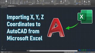
Yes Just copy the X,Y,Z Column from excel and in autocad Type PL and simply right click on the command bar and paste For 3d Pline type 3P and simple paste. You will get the polyline. Watch Part 3 of this video.
very good tutorial, it really educative. please can you help me with your data(Coordinates so that i can use it to practice what i have learned from you. thanks
Have tried coping the points from excel to autocad the points are not coming, but if l copy 10 points from a diffirent excel file the points are coming
HI, I HAVE A AUTOCAD 2014 INSTALLED. WHEN I AM TRYING TO COPY AND PASTE THE CSV FILE IN AUTOCAD IT IS NOT PASTING.TRIED ZOM AND EXTEND ALSO AFTER PASTE COMMAND. CAN YOU PLESE TELL ME WHAT IS THE PROBLEM? ASLO THE OTHER FORMULA YOU SHOWN TO MAKE CSV FILE ( OTHER THAN CONCATENATE) IS NOT ACCEPTING IN MY EXCELL FILE
Don't create csv file. Instead of that just copy the generated x,y format directly from excel and use right click on commnd bar in autocad and paste it. Don't use Ctrl+V for paste. Always use Right click and paste
sir apki attach file se ma jab point ki copy kerta hun tu mukamal copy nahy hoti while apkay 143 points hn aur meray pass 94 points aatay hn please describe thanks


[Download Link Inside]
I invested lot of time to prepare this video!
for this if you wanna gift something to me then just SUBSCRIBE our channel and stay connected with us! (Its free!)
Donate us: rzp.io/l/payLE
excel formula file download Link bellow: goo.gl/kwUhmZ
Don't forget to SUBSCRIBE us!
ua-cam.com/users/LearnExplore
Learn & Keep exploring!
Very nice & useful sir
Tnk u
Very good information. please tell how to calculate area from excel sheet(using formula) in auto cad drawing...
。。。。
As beginner I will apply what I had learned from you. God bless Boss
I hope you have the tutorial also for plotting both vertical and horizontal alignment showing element of curve. Example in vertical alignment shows pvi, pt, PC, K, etc. for simple road design using auto CAD Civil 3d
Thank you my dear friend. You save me a lot of time because I was planning to put every point by "command circle = bearings of Eastings, Northings" 1 by 1 HAHAHAHA
Yeah, don't do that, technology is our friend lol Seriously though, I am a rookie on AutoCAD but coming from the Excel world and the sheer amount of tasks that can be automated by using scripts is staggering.
THATS GREAT..MAM..BUT HOT TO SHOW THE LEVELS, COORDINATES AND THE POINT ON THE AUTOCAD FILE
Very useful video. You made many people life easy :) Guys dont forget to download his excel sheet..
Thank you 😊
Thank you Sir. Allah Bless you
Thank you, easy understanding, very useful for a surveyor or draftsman.
You are welcome. Thanks for the feedback
This is a great tutorial! Would you do a tutorial how to insert dynamic blocks with visibility states into a specific coordinates? What I'm trying to accomplish is to export my dynamic block coordinates, (with different visibility states) to an excel file and then use excel to change the coordinates so that I can import it back into a new drawing file with the location of the blocks in different coordinates.
Yes it is possible. Can you give me the data to make this tutorial?
Please send us the dwg and excel data to contact@learnnexplore.com
Surveyor report ka tarika ENZ BATAO BAHI
It's helpful. Thank you Sir.😀😀😀
Wooow thank you so much,
Really helped a lot.
Be blessed.
Most welcome
This video is very helpful full thanks a lot, Brother can you please show me how I can prepare an excel file based on the AutoCAD file in advance thanks.
Yes you can do that too. Use LIST command and export line vertex to Excel. We have a video on our channel. Please watch that too
Thank you very much
You are a life saver. Thank you!
Happy to help!
thank you very much indeed this video helped me
You are most welcome
bro u the great u solve my biggest problem and that's why i subscribed your Chanel
Very helpful.
THANK YOU !!
Thank You for your valuable feedback 😊
Thank You So Much, you saved a lot of time for me!!
Fantastic, a quick question though, how do I plot gps coordinate point on autocad?
Tnx sir....this is so good and easy...
Thank you for your valuable feedback
THANKS
thanks bri
thanks from indonesia .. very helpfull :)
Thanks for your valuable feedback 😊
Thanks a lot. You save my time!
thanks very much
Hi good day! I just follow your instruction but after that the 5 coordinates just position in one location
Please retry. Method is same
Thank you man !
Excellent sir
sir, please give more video with different examples for the learners
Thank you genius. I've learnt a lot
You are welcome
Hello, I’m currently working on a project where I need to import coordinates of power distribution network poles into AutoCAD from a CSV file. These poles vary in type (e.g., concrete, wooden, chestnut, etc.) and are defined by attributes in the CSV file. Is there a way to automatically assign different blocks or symbols to these points based on their attributes during the import process? Ideally, I’m looking for a solution that allows for the visualization of these different pole types directly in AutoCAD without manually changing the symbols for each coordinate. Any guidance or references to scripts and tools that could facilitate this would be greatly appreciated. Thank you!
Your videos are helpful but please do some work on video quality and voice quality. Do not delete these videos but remake them in good quality
Thanks for the suggestions
Very useful
valueable vedio bro ,so much thanks you bro.....
Nice good job
Oooo wonderful bro, thank you verymuch. Recently I done 900 points plotting by entering each points. Now I got it. Thanks again.
thank you for your useful and handy instructions on autocad ,
Dhanyawad (thanku very much)....
Recently I done 425 points plotting by entering each points. Now I got it. Thanks again.
Very nice appreciable 👏👏
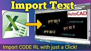
Can u please tell how to find RL
Thank you. You mean how to import RL?
No how to find RL in excel (formula)
You can get RL from field or from Google Earth. Actually I couldn't understand your question.
Ohk thank u that means X Y and RL are already given
Yes
Ty
Thank you
It is very very very veryyyyyyyyyyyyyyyyyyyy helpful, grateful to you, sir...
СПАСИБО!!!Очень полезная информация.
пожалуйста.
thanks alot sir for helping
thank you sir, this will help me in doing survey.
Amazing, thank you very much.
Thanks sir
How can I get the supportive videos' to import lines from excel data sheet part 3
Please search for "how to draw topo map"
Can we import two set of coordinates in one file
Sure u can
Hi. I'm a Civil engineering student and I just wanna ask in exporting the points to autoCAD. The result is different from urs.
Pl Follow the steps thoroughly
great job sir, carry on.
Please upload a tutorial in autocad about latitude and longitudinal and easting and northing wgs84
+radha rs
I'm not clear with your queries.
Pls tell in details
TNX Bhai!
Good video
thanks a lot sir, really helpful
Thank You Sir
ThanQ for the Video 👍🙏
THANK YOU BROTHER
VERY HELPFUL BUT THE PROBLEM WHEN I COPY AND PASTE TO AUTOCAD ONLY ONE POINT IS SEEN. PLEASE HELP
Try again.
Or try this method
Copy the column of x,y in excel
In AutoCAD use Multipoint command and then paste in command bar.
Let me know if your problem solved.
thank you sir
sir any vidu about area divission in equl parts in auto cad please will make
+Sher Muhammad
I understood your question
But this not possible in AutoCAD with a command or any automatic method.
If the shape in regular shape then it's somehow possible otherwise you have to divide any irregular shape manually in AutoCAD.
Hope you understand.
Can I move the axis to a point that would not change the value of the coordinates?
No
@@LearnExplore So that's what would really happen then (I asked because I tried it earlier).
Any tips on improving it? I've set the limits to 500000s and 2000000s, because it's that far
INTERESTING
Do You know how to do the same with pline from coordinates?
Yes
Just copy the X,Y,Z Column from excel and in autocad
Type PL and simply right click on the command bar and paste
For 3d Pline type 3P
and simple paste.
You will get the polyline.
Watch Part 3 of this video.
Hi, how to put text coordinate short cut because every point in need to type one by one the coordinate. Thanks and God bless.
Use PDSIZE command in AutoCAD and reduce point size as per your convenient.
very good tutorial, it really educative. please can you help me with your data(Coordinates so that i can use it to practice what i have learned from you. thanks
Happy to hear from u..and Give ur mail id i will send the file
amadusarjohbah@gmail.com
amadusarjohbah@gmail.com
I have sent you ..check your mail box
i have checked my inbox and i have not seen any message from you. Kind Regards
Thank sir
How to Convert Higher version autocad file to Lower version more then 2 one time?
Sir normal excel se hoga... Na alagse export to excel bolke kuch excel hay plzzz help me sir... Plz
Normal excel se hi hoga
Thnx sir..... I'm done sir
Have tried coping the points from excel to autocad the points are not coming, but if l copy 10 points from a diffirent excel file the points are coming
Use Z enter E enter
or change point style
Thank you very much .
How could u get specifically these points while google earth gives lot many coordinates.Would u tell me how did u do that?
By DGPS Surveying
nice video.
Its Great to hear that
HI, I HAVE A AUTOCAD 2014 INSTALLED.
WHEN I AM TRYING TO COPY AND PASTE THE CSV FILE IN AUTOCAD IT IS NOT PASTING.TRIED ZOM AND EXTEND ALSO AFTER PASTE COMMAND.
CAN YOU PLESE TELL ME WHAT IS THE PROBLEM?
ASLO THE OTHER FORMULA YOU SHOWN TO MAKE CSV FILE ( OTHER THAN CONCATENATE) IS NOT ACCEPTING IN MY EXCELL FILE
Don't create csv file. Instead of that just copy the generated x,y format directly from excel and use right click on commnd bar in autocad and paste it. Don't use Ctrl+V for paste. Always use Right click and paste
thanks
U r welcome ☺️
How to set point id
sir if we have a theodolite data that be in degree minute and second can we import it from excel to auto cad
Yes...u can
Yes. First convert it in UTM and go for this procedure
nice
Please send me the topo surveying points. I will try my auto cad.
Link already given
Is it from google earth u took coordinates?
how to do import point to volume finder in autocad
What does RL and S.L. in the file means? Please help
Reduced level
Sir can you send the link of final drawing of these coordinates.
Link already given...pls check in the comment section
Do U need autocad drawing?
yes sir the final drawing of these coordinates so that I can practice check my drawing.
Share ur email id
manthansharma144@gmail.com
sir apki attach file se ma jab point ki copy kerta hun tu mukamal copy nahy hoti while apkay 143 points hn aur meray pass 94 points aatay hn please describe thanks
Download the file.
Otherwise send your mail id I will send you the original file
Apna mail id vejo
+imtiaz ahmed
App ka question me samjha nahi..pls decribe in detail
Sir plzz send me my mail I'd
Khanmahbub655@gmail.com
Check the file I have sent in your email
Learn & Explore thank you sir
Excel sheet is not opening plz help me to open/download
Download it and open. and click enable
I can't snap the centerline is there a way to snap it?😭
Use SE command and on object snap mode
it keeps on asking to specify a point, what to do?
+jonhy720
Copy the PO and (E,N) column and paste that in the white command bar
send you the link of it
See description
Can't paste the file. Still ask specify a point. Help me please
Someone pls explain
hi,pls muze village map ka data auto level bearing se exel sheet to cad me kaise convert karte hai guide kare pls
For this I will suggest a video to u...watch in detail ua-cam.com/video/e1_gRaY-xFs/v-deo.html
Noice
Bro fist point only inside the put autocad another point can't past bro
Watch the video carefully
Coordinate unit should be meter
It is unitless
how to enter XY and Z also in CAd?>???????????? Pls Help
Make format of x,y,z in excel and follow same step as shown.
In case of polyline using x,y,z Use 3P command instead of PL
Pls I need your help....can I get your number???
Pls help me brother....
Use Civil 3D to import points . It is very easy
+Chamara Prasanna
Thats right sir
But when you don't have civil 3D then it will help you to work with.
bhai mere pass na autocad me copy hi nhi hore baqi ka pura hora process hora
Don't use Ctr+C to copy.
Just right click and select copy.
How to import data Excel form AutoCAD with description
Please See our videos in 'Excel & AutoCAD' playlist
How to import RL of that point
Another video uploaded for this
sir ami jokhn paste korchi tokhon kintu amar hocche na
ki problem aktu bolben
Command bar e left click then right click kore paste korte hbe. File ta download kore nau. Pinned comment e link deoa ache
@@LearnExplore ok sir
You Can see on the following video about coordinates using lisp
ua-cam.com/video/J1GK5tIzR7w/v-deo.html